Return to the Gulf of Mexico

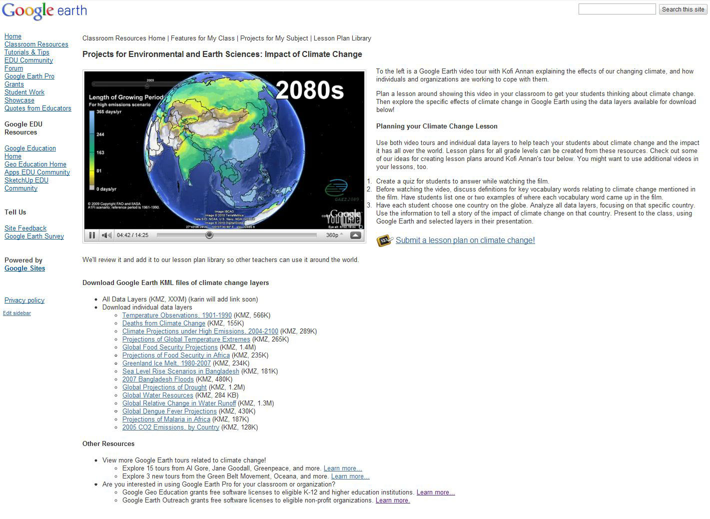
With support from Google, the Waitt Foundation, Hope Spots LLC and the National Geographic Society, Sylvia Earle and Mission Blue are embarking on an expedition to the Gulf of Mexico that will take a deep look at how the region is recovering from the five million gallons of oil spilled from the BP Deep Horizon Oil Spill last year. Follow along with the expedition by checking back daily and clicking on the blue ship icon in Google Earth located off of the US coast near Pensacola, Florida, where the expedition begins (make sure the Places layer is turned on). The science team will share updates and media from the expedition, including photographs, videos and links to Google maps on the National Geographic News Watch blog here.
“Our goal is to identify areas with potential for Gulf ecosystem recovery,” said Dr. Earle, founder of SEAlliance and recipient of the 2009 TED Prize that developed into Mission Blue, an international ocean conservation movement. “That is going to require protection of places healthy enough to replenish and rebuild populations. What’s happened here is far from over for the clams and oysters and other sea life critical to a healthy Gulf of Mexico.”

The fate and impact of the spilled oil, gas and dispersants applied following the blowout into the Gulf are the subject of intense discussion by experts. The expedition team, assembled under the broad banner of the Mission Blue initiative, seeks answers to questions about the current status of key species and ecosystems.

Other research participants include: Dr. Thomas Shirley, Larry McKinney, Douglas Weaver and Harriet Nash from the Harte Research Institute at Texas A&M University-Corpus Christi; Edith Widder and Brandy Nelson, Ocean Research & Conservation Association and Carl Safina, Blue Ocean Institute. Research dives are planned using a Dual Deepworker submersible made available to the expedition by the Waitt Institute.

You can also experience the expedition for yourself by downloading this KML for viewing in Google Earth.

Daniel Tunkelang Leaving Google Maps to Join LinkedIn

Daniel Tunkelang has announced on his blog today that he is leaving his position at Google Maps for an exciting research position at LinkedIn. Daniel was hired at Google about a year ago. There he worked on authority pages and the of mapping businesses to their official home pages.

When Daniel was first hired at Google as an engineer he did something that was amazing and delightful. He reached out to me, looking to understand issues and concerns that I had with Google Maps and their approach to Local. We initially had several detailed email exchanges and a long telephone call. He was gracious, inquisitive and forthright. All things that I respect and honor. He reached across a chasm that typically exists between Google and me and was sincere in his efforts to understand my critiques. Google could learn much from his outreach efforts (although as he pointed out personal contact doesn’t scale well :) ).

We have stayed in touch, off and on throughout the year and I have appreciated the occasional communications and (personal) assistance that he has provided. Even though I don’t know him in a truly personal sense, I consider him a friend and wish him well at LinkedIn.

Learn about the human side of climate change with Kofi Annan

[Cross-posted on the Google.org and Official Google Blog]

Climate change is too often misunderstood to be simply an environmental issue, rather than a human issue. For our children and grandchildren, climate change is an issue of public health, economics, global security and social equity. This human side of climate change is explained in a new Google Earth tour narrated by former U.N. Secretary General Kofi Annan. Within these stories, you’ll find data and tools to explore this topic in more depth, and meet some of the people who are actively working on managing the risks of climate variability and change. We encourage you to take the tour to learn more about these human issues and the inspiring work of groups like the Alliance for a Green Revolution in Africa (AGRA) that are helping farmers cope with climate change. We hope this video will serve as a useful tool as educators help students around the world understand the complexity of this issue.

This is the latest in our series of climate change tours that we’re releasing leading up to the global U.N. Framework Convention on Climate Change (COP16) talks in Cancun, Mexico this week.

As part of the Google Earth for Educators Community, we’ve also created a special Climate Change Educators Resources page that teachers can use in their classrooms. Here, teachers can find the tools they need to create lesson plans about climate change, including all the individual Google Earth KML layers available for download. Teachers and students can overlay multiple data layers that help illustrate climate change, and discuss and analyze them as part of K-12 and higher education curriculum. We’re also looking for lessons plans for any school grade that use this narrated tour or these Google Earth KML layers, so if you’re a teacher or instructor, please submit your lesson plan for review now.


Visit google.com/landing/cop16/climatetours.html or the Climate Change Educators Resources page to learn more about climate change today.