Google Maps and Earth – Post-tornado mapping

This past week, several devastating tornadoes struck across a wide swathe of the southern United States. Our Crisis Response team is activating to provide data and imagery we hope will be useful to first responders and the general public.

In cooperation with our satellite partner GeoEye, we have imagery of the aftermath of several tornadoes, including in Tuscaloosa, Alabama as shown below. We have created several before-and-after comparisons in a Picasa album.

Left: Google imagery from late 2010. Right: GeoEye imagery from Thursday, April 28.
Top: Charleston Square Apartments, Tuscaloosa, Alabama. Bottom: Towns of Pleasant Grove, Concord, and Hueytown, Jefferson County, Alabama. Click to see enlarged.

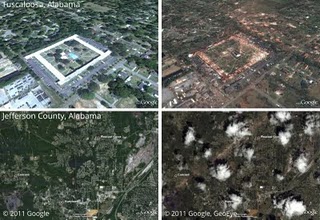
This imagery, as well as data sets such as Red Cross shelter locations and tornado touchdown reports, are available in this collection on Google Maps. We will continue to add imagery and data as it comes available.

Our heart goes out to everyone affected by this tragic event.

Update: You can now access the satellite imagery directly in Google Earth. Make sure the Places layer is enabled, then go to Alabama. Click the image of a tornado to find links to load the images.

Cancun Map – Google Map of Cancun

This super detailed Cancun Map Displays Hotels, Restaurants, Nightclubs, Markets, Beaches, and much more using the tools provided by Google API Satellite Maps. Besides the incredible ZOOM, It has an amazing Interactive menu that lets you choose what should be display on the Cancun map and it also has the Virtual Tours of all Cancun hotels, malls, public areas and beaches.

Stunning imagery of Tropical Cyclone Yasi

As you probably heard, Tropical Cyclone Yasi recently made landfall just south of Cairns, Australia. Residents have had plenty of time to make plans, so hopefully most were able to get out of the path of the storm.

Yesterday, NASA’s Aqua satellite captured an amazing image of the storm, which you can see here:

yasi.jpg

To view that image in Google Earth, simply download this KML file.

Another great source of information about the storm was the aus-maps severe weather page. They had a lot of info on the page, and also included special maps such as this one, from which you could pull down the KMZ file and view it yourself in Google Earth.

aus-emaps.jpg

There has also been some very useful threads over in the Google Earth Community, with users sharing information and files as quickly as they became available.

Finally, don’t forget about the Weather Layer that’s built into Google Earth. The forecasts aren’t particularly helpful for a storm like this, but quick access to the satellite imagery for the area is certainly a great feature to have.