The state of Sarawak, in Malaysian Borneo, is the site of an interesting political battle recently. Their Chief Minister claims that 70 of Sarawak’s forest cover is intact, but imagery from Google Earth seems to indicate that it’s far worse than that. In fact, some environmentalist groups estimate that logging has cost Sarawak 90 of it’s primary forest cover.
Mongabay has written a very detailed article about this situation, including quite a few photos. For example, the image below clearly shows logging roads all throughout Sarawak, while virtually none are visible in Brunei to the north.
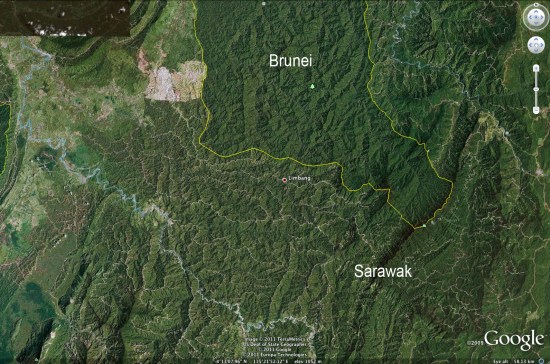
Google Earth is making it increasing difficult for governments to lie about this kind of behavior. As the pace and quality of imagery updates continue to improve, things will only get better for those that wish to expose this type of thing.
Be sure to read the entire article on Mongabay for more information and many more photos.
 or you can