The technology in crisis

In many ways, the arrival of Hurricane Irene last week drove home the importance of National Preparedness Month, an effort from the FEMA Ready campaign to encourage Americans to take steps to prepare for emergencies throughout the year. With people relying on the Internet worldwide, it’s not surprising that Google search data and a recently released American Red Cross survey show that people turn to online resources and tools for information and communication during major crises. First responders, who provide services in the aftermath of disasters, are also finding Internet and cloud-based tools and information useful—for improving their understanding of a situation, collaborating with each other and communicating with the public.

Today, in preparation for September’s National Preparedness Month, our Crisis Response team is introducing a new Google Crisis Preparedness website with information and educational tools on using technology to prepare for crises. On the site, you can see how individuals and organizations have used technology during crises in the past, including how two girls located their grandfather after the Japan earthquake and tsunami in March of this year and how Americorps tracked volunteers during the tornadoes in Joplin, Missouri in May of this year. There’s a section for responders with information on using Google tools in crises, such as collaborating efficiently using Google Docs, Spreadsheets and Sites, visualizing the disaster-related information with Google My Maps and Google Earth, and more.

Also, you can access a new public preparedness web resource launching today: Get Tech Ready, developed as a collaboration between FEMA, the American Red Cross, the Ad Council and Google Crisis Response. There, you’ll find tips on using technology to prepare for, adapt to and recover from disasters, for example:

  • Learn how to send updates via text and internet from your mobile phone in case voice communications are not available
  • Store your important documents in the cloud so they can be accessed from anywhere or in a secure and remote area such as a flash or jump drive that you can keep readily available
  • Create an Emergency Information Document using this Ready.gov Emergency Plan Google Docs Template, or by downloading it to record and share your emergency plans and access them from anywhere

We encourage you to take a moment now to see how simple, easy-to-use and readily-available technology tools can help you prepare for a crisis. You’ll be more comfortable using these tools in the event of a disaster if you’ve already tried them out—and even integrated them into your daily life.
Google Apps highlights

Over the last few weeks, Google added a few frequently-requested improvements to Google Apps, including offline access in Gmail, Calendar and Docs, page numbering in documents, and page-level permissions in Google Sites. If you’ve been waiting for these features, please give them a try!

Work offline in Gmail, Calendar and Docs

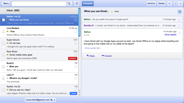
You can connect to the Internet in more and more places now, but you probably occasionally find yourself in situations when you can’t use web apps because of spotty connectivity. Now you can stay productive even without a connection in Gmail, Calendar and Docs on Chrome, thanks to new offline capabilities for each of these applications.

Free calls home for overseas U.S. Military personnel

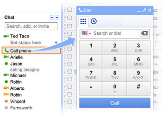
On Tuesday, Gmail also added the ability for all U.S. Military personnel with valid .mil email addresses to call the United States for free. We appreciate the hardships our troops face, and we hope to make staying in touch with friends and family a little easier for them while they’re deployed.

Page numbers in Google Docs

A while back we added page headers and footers in Google Docs, and now you can add automatic page numbers at the top or bottom of your pages. We’ve heard from plenty of students and teachers who asked for this feature, so we’re glad to be making Google Docs just a little bit better for them.

Page-level permissions in Google Sites

Sometimes project sites are most useful when the whole team can access everything in the site, but there are other situations—like when you’re sharing a site with a client—when you might not want everyone to have full access. That’s where page-level permissions come in handy. It’s a simple way to specify who can see each page in your Google Sites.

Administrative audit history

Another useful feature that we added for organizations this week is administrative change reporting. This new area of the control panel lets admins see a record of administrative changes that have been made to their Google Apps setup, including changes to user accounts, application settings, mobile settings and administrative delegation.

Who’s gone Google?

More than 4 million businesses are using Google Apps now, and the wave of organizations switching over continues to accelerate. Yesterday at Dreamforce, Eric Schmidt shared a couple new details about the growing momentum in this area, including the fact that more than 5,000 businesses sign up each day, and that there are more than 40 million total active users in organizations using Google Apps.

To get a flavor of how organizations are putting Google Apps to work, Viocorp, North Carolina A&T State University and Lamar Advertising shared their stories over the last few weeks.

Google Maps Mashups 6

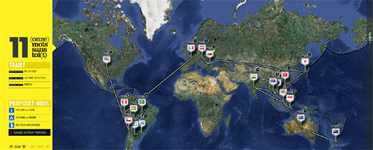
A cool Google Map mashup  of two French guys journey

Phillipe and Josue are two French guys who have taken a year’s sabbatical and decided to travel around the world. To help the world follow their journey they have created a cool Google Map of their journey that they call, 11 (onze) Mois sans toi(t)

The map shows all the stops that the pair have made on their journey so far. The information for each window includes Tweets, Facebook updates and photographs taken at that location. The map also includes the option for users of the map to add places of interest around the world that they think the guys should visit on their journey.

Your Story with Google Maps

I’m sure everyone has a story to tell – and you can tell yours with this Google Map.

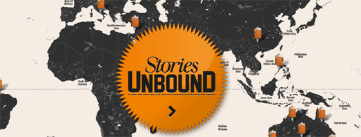
Stories Unbound was created for the Melbourne Writers Festival. It is a social media platform (website and iPhone app), that lets users write and geotag stories wherever and whenever the mood strikes.

You can read submitted stories by selecting a marker on the map. It is also possible to select a story from the slide-out sidebar, where you can also submit your own story by selecting a location on the map.

The Google Maps interface for Stories Unbound uses Google Map Styles to create a map which is in keeping with the Melbourne Writers Festival brand. The clean look of the map, with most of the map labels removed, also creates a clean interface, which encourages the user to explore stories by location.

Google Maps for Flash

Google has announced that the Google Maps API for Flash has been deprecated. This means that no new features will be developed, and only critical bugs, regressions, and security issues will be fixed in the API.

Google says that “use of the Maps API for Flash remains a small percentage of overall Maps API traffic, with only a limited number of applications taking advantage of features unique to the Maps API for Flash.”

Perhaps the one unique feature available in the The Maps API for Flash and not available in the JavaScript API is the 3DMap object. The 3DMap object allows Flash map developers to create oblique map views and rotate Google Maps. It does seems to be a unique feature that was used very little.

The only map that I can remember that used this feature was a really cool application that let you create your own weather map. However the application no longer seems to exist. Luckily I did manage to video the application when it was released, so you can view the 3DMap object put to good use in the video below.

Sadly for map developers the Yahoo Maps API is also on the way out. From September 13th Yahoo will no longer support:

  • ActionScript 2 & 3 (Flash APIs)
  • AJAX Maps 3.6, 3.7, 3.8
  • REST API (Map Image API)
  • Simple API – (No coding)
  • GeoRSS – Version 2

Google Geo Developers Blog

Ghostly International Live Map

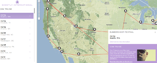
The record label and art company Ghostly International has created a Ghostly International – Live Map so that you can follow all their currently performing artists.

The Live Map lets you select an individual artist from the map sidebar and view all their upcoming events on a Google Map. When you select an artist from the sidebar an information window opens with a brief bio of the selected artist.

45° Imagery for 24 cities

Google Maps has had another big update of 45° (bird’s eye view) imagery. 24 new cities, including Lausanne, Switzerland and Girona, Spain, now have oblique view imagery in Google Maps.

To mark the occasion I have put together this Aerial View Slideshow, to highlight some of the best of the 45° imagery now available in Google Maps.

Google LatLong

Local Events with Google Maps

WeGooo is a Google Maps based application for finding nearby events.

Once you enter a location WeGooo displays a Google Map of the location with a time-line of nearby events. You can browse the events in chronological order from the time-line or find events by location by selecting a venue’s marker on the map.

It is possible to change your location on the map by dragging the ‘That’s me’ marker to a new position. If you select an event from the time-line the map will also display a route from your current location to the selected venue.

Fun with Google Maps

The Art of Running – A Tribute to Steve Jobs

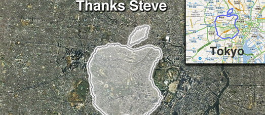
Apparently someone called Steve Jobs got a new job this week, news of which seemed to send the world reeling. The news certainly seemed to have a strange effect on Joseph Tame.

Using his iPhone and RunKeeper Joseph set out to create a giant geoglyph of the Apple logo by running around Tokyo.

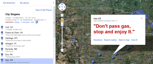
Don’t Pass Gas

City Slogans is a Google MyMap of witty slogans that towns in the U.S. have invented to try to entice you to visit.

Amongst the gems on offer is Hooker, OK with “It’s a location, not a vocation” and Algona, IA with “Home of the World’s Largest Cheeto”.

So Long and Thanks for all the Fish

The Google Maps Street View trike has taken a visit to Seaworld Orlando. On his visit he took a number of photographs including this shot of the performing dolphins.