Imagery Update – Week of November 1st

The Google Earth and Maps Imagery team has just released another extensive batch of aeriel and satellite images for your enjoyment! In honor of the upcoming U.S. holiday Veterans Day (November 11th), we’ll take a look at a few military-themed museums.

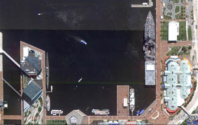
Let’s start with a wide-view of the naval ships on display at the Baltimore Maritime Museum in Baltimore, Maryland. Historic ships that you can zoom in on and see close up in Google Earth or Maps include the last sail-only warship USS Constellation (lower left); the submarine USS Torsk (upper left) which sunk the last enemy ship in World War II; and the cutter USCGC Taney (upper right), the last ship still floating that fought during the Pearl Harbor attack.

Baltimore Maritime Museum in Baltimore, MD

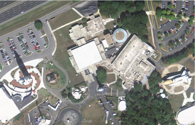
Now that we’ve got our sea legs, let move sub-orbital and beyond at the U.S. Space and Rocket Center in Huntsville, Alabama. Here we can see a restored Saturn V-1 “moon shot” test vehicle and the A-12 Oxcart “Blackbird” spy plane.

U.S. Space and Rocket Center in Huntsville, AL

These are just a few examples of the many museums around the globe that are included in our latest imagery batch.

High Resolution Aerial Updates:
USA: Baltimore, Cedar Rapids, Huntsville, Long Island, Redding, Springfield (IL), St. Joseph (MO)
Austria: Schladming
Finland: Pori
Ireland: Athlone, Drogheda, Dundalk, Enniscorthy, Galway, Limerick, Monaghan, Tralee, Waterford,
Spain: Vasco

Countries receiving High Resolution Satellite Updates:
Albania, Algeria, American Samoa, Angola, Argentina, Armenia, Australia, Austria, Azerbaijan, Bangladesh, Belarus, Benin, Bolivia, Botswana, Brazil, Bulgaria, Burkina Faso, Burundi, Cameroon, Canada, Central African Republic, Chad, Chile, China, Colombia, Costa Rica, Cuba, Côte d’Ivoire, Democratic People’s Republic of Korea, Democratic Republic of the Congo, Ecuador, Egypt, El Salvador, Equatorial Guinea, Eritrea, Ethiopia, Finland, Former Yugoslav Republic of Macedonia, France, Georgia, Germany, Ghana, Greece, Guatemala, Guinea, Guinea-Bissau, Guyana, Honduras, Hungary, India, Indonesia, Iran, Ireland, Kazakhstan, Kenya, Kyrgyzstan, Lesotho, Liberia, Libya, Madagascar, Malawi, Malaysia, Mali, Mauritania, Mauritius, Mexico, Moldova, Mongolia, Montenegro, Morocco, Mozambique, Myanmar, Namibia, Nepal, New Zealand, Nicaragua, Niger, Nigeria, Norway, Oman, Pakistan, Panama, Paraguay, People’s Republic of the Congo, Peru, Philippines, Poland, Portugal, Romania, Russia, Rwanda, Saudi Arabia, Senegal, Sierra Leone, Somalia, South Africa, Spain, Sudan, Suriname, Swaziland, Taiwan, Tajikistan, Tanzania, Thailand, The Bahamas, Togo, Tonga, Tunisia, Turkey, Turkmenistan, Uganda, Ukraine, United Arab Emirates, United Kingdom, United States, Uruguay, Uzbekistan, Venezuela, Vietnam, Yemen, Zambia, Zimbabwe

These updates are currently only available in Google Earth, but they’ll also be in Google Maps soon. To get a complete picture of where we updated imagery, download this KML for viewing in Google Earth.

KML, Traffic, and Bicycling layers come to Maps API v3

Since being formalized as an Open Geospatial Consortium standard, KML has become something of a lingua franca for geospatial information. From humble beginnings in Google Earth, KML support can now be found in a wide variety of mapping products and services. Today we’re happy to add Maps API v3 to this list with the introduction of the new KmlLayer class. The KmlLayer class enables KML or GeoRSS files that are hosted on publicly accessible web sites to be rendered in a Maps API v3 application.

The KmlLayer class is just one of several new layer classes we’re adding to Maps API v3 today. A layer class handles a collection of overlays that are added to the map as a single entity. In addition to the KmlLayer class, we are also adding a TrafficLayer class and a BicyclingLayer class.

The TrafficLayer class adds real time color coding of traffic speed on highways and major arterial roads. The BicyclingLayer class adds information about bike trails, lanes and recommended roads for bicyling onto the map:

  • A dark green line indicates a dedicated bike-only trail;
  • A light green line indicates a dedicated bike lane along a road;
  • A dashed green line indicates roads that are designated as preferred for bicycling, but without dedicated lanes

If you generate bicycling routes using the DirectionsService class, and display them on the map using a DirectionsRenderer, the BicyclingLayer is now added to the map with the route.

You can use the map below to try out these new layers and check how your own KML files are rendered by the KmlLayer class:

If you have any questions about these new layers, or the Maps API v3 in general, we recommend that you join the Maps API v3 Google Group. For more information about KML, check out the KML Tutorial.

Posted by Thor Mitchell, Maps API Product Manager

How Google Maps Led to An Accidental Invasion


Recently a Nicaraguan military commander invaded a Costa Rican territory and ordered troops to take down a Costa Rican flag and replace it with Nicaragua’s. He went through all this trouble because of an error on Google Maps.

A Nicaraguan military commander recently invaded Costa Rican territory, and ordered troops to take down a Costa Rican flag and replace it with Nicaragua’s. Was this the work of a brash commander, going rogue on his superiors? A new policy of Nicaraguan imperialism? Neither. The incident was caused by an error in Google Maps.

SearchEngineLand translates the details from La Nación, Costa Rica’s largest newspaper, which reported that commander Eden Pastora blamed the incursion on a misleading border on Google Maps that was off by some 3000 meters.

La Nación points to a disparity between the borders on Bing and Google. We’ve highlighted the area in question.
A Google spokesperson was unsure what caused the mapping error. Whatever the answer, this could play into Bing’s next marketing strategy: Bing, the search engine that doesn’t cause international disputes.

You may well blame the Nicaraguan military for using Google Maps — which, for all its usefulness in everyday life, is a relatively imprecise tool for official exercises near borders. But it’s been little more than three years since the British Navy had the same problem, straying into Iranian waters by accident (Iran being far more dangerous than Costa Rica, which doesn’t even have a full-time military) and blaming its military-grade GPS equipment for the error. A month before that, the Swiss military blundered into Lichtenstein on a training exercise — because, they said, it was dark. That, at least, was one border crossing Google Maps might have prevented.