The quest for the perfect map

(Cross posted from the Official Google Blog)

For the last decade we’ve obsessed over building great maps for our users—maps that are totally comprehensive (we’re shooting for literally the whole world), ever more accurate and incredibly easy to navigate.

Comprehensiveness

It’s a pretty limited search engine that only draws from a subset of sources. In the same way, it’s not much of a map that leaves you stranded the moment you step off the highway or visit a new country. Over the last few years we’ve been building a comprehensive base map of the entire globe—based on public and commercial data, imagery from every level (satellite, aerial and street level) and the collective knowledge of our millions of users.

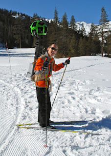
Today, we’re taking another step forward with our Street View Trekker. You’ve seen our cars, trikes, snowmobiles and trolleys—but wheels only get you so far. There’s a whole wilderness out there that is only accessible by foot. Trekker solves that problem by enabling us to photograph beautiful places such as the Grand Canyon so anyone can explore them. All the equipment fits in this one backpack, and we’ve already taken it out on the slopes.

Luc Vincent, engineering director, taking the Street View Trekker for a trial run in Tahoe

Accuracy

The next attribute map makers obsess over is accuracy. We still have a way to go because the world is constantly changing—with new houses, cities and parks appearing all the time—it’s a never ending job. But by cross-checking the data we have, we can significantly improve the accuracy of our maps. Turns out our users are as passionate about the quality of Google Maps as we are, and they give us great feedback on where we can do better. We make thousands of edits a day based on user feedback through our Report a Problem tool and via Map Maker, which we launched in 2008. Today we’re announcing the expansion of Map Maker to South Africa and Egypt, and to 10 more countries in the next few weeks: Australia, Austria, Belgium, Denmark, Finland, Liechtenstein, Luxembourg, New Zealand, Norway and Switzerland.

Usability

The final element of the perfect map is usability. It’s hard to remember what digital maps were like before Google Maps went live in 2005, and the huge technological breakthroughs that transformed clicking on arrows and waiting, to simply dragging a map with a mouse and watching it render smoothly and quickly. Plus, we added one single search box. Today we have thousands of data sources that feed into our maps making them a rich and interactive experience on any device—from driving directions to transit and indoor maps to restaurant reviews.

People have been asking for the ability to use our maps offline on their mobile phones. So today we’re announcing that offline Google Maps for Android are coming in the next few weeks. Users will be able to take maps offline from more than 100 countries. This means that the next time you are on the subway, or don’t have a data connection, you can still use our maps.

The next dimension

An important next step in improving all of these areas—comprehensiveness, accuracy, and usability of our maps—is the ability to model the world in 3D. Since 2006, we’ve had textured 3D buildings in Google Earth, and today we are excited to announce that we will begin adding 3D models to entire metropolitan areas to Google Earth on mobile devices. This is possible thanks to a combination of our new imagery rendering techniques and computer vision that let us automatically create 3D cityscapes, complete with buildings, terrain and even landscaping, from 45-degree aerial imagery. By the end of the year we aim to have 3D coverage for metropolitan areas with a combined population of 300 million people.

I have been working on mapping technology most of my life. We’ve made more progress, more quickly as an industry than I ever imagined possible. And we expect innovation to speed-up even more over the next few years. While we may never create the perfect map … we’re going to get much, much closer than we are today.
Google Earth Imagery: The end of October

What do Elvis’ Graceland and Iran’s Marmar Palace have in common? Both estates have been updated with new imagery in Google Earth and Google Maps!

Over the last few weeks, the imagery team has updated hundreds of images. To give you a taste of this new data, today we’ll look at several interesting features that have been updated with new imagery from across the globe.

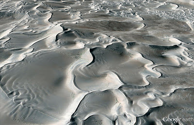
First, I’d like to look at a fantastic and majestic terrestrial landform known as the star dune. Star dunes form pyramidal shapes that grow upward and are characterized by multiple radiating dune crests. Shown below is a perspective satellite image of a star dune field within the Badain Jaran Desert of China. The desert contains Earth’s tallest stationary dunes, reaching heights of 500 meters!

Perspective view of star dunes of Badain Jaran Desert, China
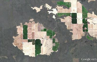
One of my favorite hobbies is scrambling around volcanic sites throughout the western United States, and many of my favorite areas are located in Idaho’s Snake River Plain. Within this river plain, one of the youngest volcanic flow features of the region comprises the Hell’s Half Acre lava flow field. In the aerial image below, taken this past September, you can see “windows” of older river bed material (now farmland) that were not buried during lava flow emplacement.

Farmland enclosed by lava flow, Snake River Plain, Idaho
Can you identify the unusual feature relationship seen in the satellite image below? Yes, train tracks cut to the northeast across the airport runway! Those tracks belong to the Kyber Railway, and their two vintage steam locomotives take passengers 42 kilometers to the town of Landi Kotal in Pakistan’s mountainous Kyber Pass.

Peshawar International Airport, Pakistan
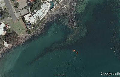
Below is a fun water sport activity captured in high resolution aerial imagery of the southeastern coast of Auckland, New Zealand. You can see the kayakers paddles as well as the submerged sandbars and boulders of Thorne Bay.

Kayakers in Thorne Bay, New Zealand
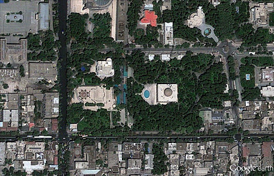
We can see the Marmar Palace of Tehran, Iran, a.k.a the Marble Palace in the updated satellite image below. It is associated with the Pahlavi dynasty, and is still used today by the Iranian government.

The Marble Palace, Tehran, Iran.
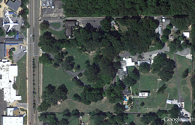
In my opinion, most good things start and end with Elvis references, so our last example showcases updated imagery of Graceland, including the private customized Convair 880 jet Elvis used while hopping across the globe.

Graceland, Memphis Tennessee
If you’d like to receive an email notification when the Earth and Maps Imagery team updates your favorite site(s), we’ve got just the tool: The Follow Your World application!

These are only a few examples of the types of features that can be seen and discovered in our latest batch of published imagery. Happy exploring!

High Resolution Aerial Updates:
USA: Bellingham, WA; Bemidji, MN; Brookings, SD; Davenport, IA; Emporia, KS; Grinnel, IA; Idaho Falls, ID; Klamamth Falls, OR; Lawrence, KS; Lovell, WY; Nephi, UT; Pittsfield, MA; Portland, OR; San Francisco Peninsula, CA; Scottsbluff, NE; Seattle, WA; St Louis, MO; Terre Haute, IN; Wasco, OR; Williston, ND; Wolf Point, MT

Spain: Huesca, Logrono

Countries/Regions receiving High Resolution Satellite Updates:
Angola, Antarctica, Argentina, Australia, Bahrain, Brazil, Cameroon, Canada, Chad, Chile, China, Colombia, Cuba, Côte d’Ivoire, Democratic Republic of the Congo, Ecuador, Ethiopia, Gaza Strip, Greenland, Hungary, India, Indonesia, Iran, Israel, Jan Mayen, Japan, Jordan, Kazakhstan, Latvia, Libya, Lithuania, Malawi, Mexico, Morocco, Mozambique, Namibia, New Zealand, North Korea, Pakistan, Paraguay, Peru, Philippines, Poland, Romania, Russia, Saudi Arabia, Senegal, Slovakia, South Africa, Spain, Svalbard, Taiwan, Tanzania, The Gambia, Turkey, Uganda, Ukraine, United States, West Bank, Yemen, Zambia, Zimbabwe

Google Earth: Imagery Update Last Week of August

The Google Earth and Google Maps Imagery Team just published a new batch of aerial and satellite imagery, and as always, there’s all kinds of fascinating sites and features to check out.

We’re now deep into the dog days of summer. When I was growing up in Chicago, my siblings and I would be acting a bit stir crazy by this time in our summer breaks. So what did our wise parents do? They’d pile us into the confined space of the family car and proceed to road-trip it for a few weeks. My parents are history buffs, so our destination spots were typically of historical significance. To commemorate these fond memories, in this post we’ll look at locales seen in our newly published imagery that would typically fit the destination profile of my family.

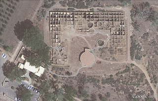
Our first example seen below is from high-resolution aerial imagery acquired this past June. The locale is a U.S. National Park located in San Juan County, New Mexico and contains 11th to 13th century structures constructed by the Anasazi Indians, the ancestors of the more commonly known Pueblo Indians. This site is included in the UNESCO list of World Heritage Sites.

Aztec Ruins National Monument, New Mexico

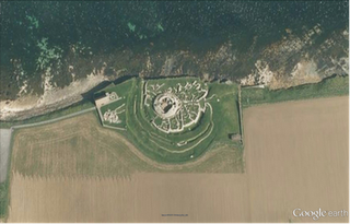
Family vacations outside of the U.S. happened on occasion and when they did, my dad’s fondness for Led Zeppelin would often lead us to any castle or related ruin in sight. In this aerial image, we can see the Broch of Gurness village located on the northwestern coast of Mainland Orkney, Scotland. The top of the central, circular broch structure has collapsed, and we can see the settlement remains that encircle the broch. The site dates to at least 60 AD.

Broch of Gurness, Scotland

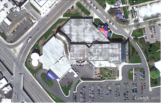
Finally, if we were good children and did not get our peanut butter sandwiches all over the car upholstery, we might be treated to visit a place such as the National Toy Hall of Fame, located in the Strong National Museum of Play, Rochester, New York. Some of the 47-and-counting enshrined toys include road-trip friendly icons such as the stick, cardboard box, ball, and of course Silly Putty!

National Toy Hall of Fame, Rochester, New York

Do you have a place you love for which you’d like to receive a notification when the Earth and Maps Imagery team updates the site? We’ve got just the tool: The Follow Your World application!

As always, these are but a few examples of the types of features that can be seen and discovered in our latest batch of published imagery. Happy exploring!

High Resolution Aerial Updates:

USA: Abilene, TX; Avenal, CA; Bakersfield, CA; Big Spring, TX; Bowie, AZ; Buckeye, AZ; Carlsbad, NM; Casa Grande, AZ; Columbia, MO; Dalhart, TX; Dayton, OH; Des Moines, IA; Farmington, NM; Ft Worth, TX; Joplin, MO; Junction, TX; Monahans, TX; Nogales, AZ; Omaha, NE; Paducah, KY; Payson, AZ; Rochester, NY; Sacramento, CA; Sioux City, IA; Tulsa, OK; Visalia, CA; Wilcox, AZ

Scotland: Aberdeenshire, Clova, Islay, Jura, the Orkney Islands, and the Shetland Islands

Sweden: Dalarnas Län, Gotlands Län, Norrbottens Län, Oland, Örebro Län, Västerbottens Län, and Västernorrlands Län

Countries/Regions receiving High Resolution Satellite Updates:

Albania, Algeria, Angola, Antarctica, Argentina, Armenia, Australia, Austria, Azerbaijan, Bahrain, Bangladesh, Benin, Bhutan, Bolivia, Bosnia and Herzegovina, Botswana, Brazil, Bulgaria, Burkina Faso, Burundi, Cambodia, Cameroon, Canada, Cape Verde, Central African Republic, Chad, Chile, China, Colombia, Cuba, Côte d’Ivoire, Democratic Republic of the Congo, Djibouti, Dominican Republic, Ecuador, Egypt, Equatorial Guinea, Eritrea, Ethiopia, Fiji, Finland, France, Georgia, Ghana, Greece, Greenland, Guatemala, Guinea, Guinea-Bissau, Honduras, Hong Kong, Iceland, India, Indonesia, Iran, Jamaica, Japan, Jordan, Kazakhstan, Kenya, Kuwait, Laos, Lesotho, Liberia, Madagascar, Malawi, Malaysia, Mali, Marshall Islands, Mauritania, Mexico, Mongolia, Morocco, Mozambique, Myanmar, Namibia, Nepal, Netherlands Antilles, New Zealand, Nicaragua, Niger, Nigeria, North Korea, Norway, Oman, Pakistan, Panama, Papua New Guinea, Paraguay, Peru, Philippines, Poland, Republic of the Congo, Romania, Russia, Rwanda, Saudi Arabia, Senegal, Serbia, Singapore, Somalia, South Africa, South Korea, Spain, Sri Lanka, Sudan, Svalbard, Sweden, Switzerland, Syria, Tanzania, Thailand, Togo, Turkey, Turkmenistan, Uganda, Ukraine, United Arab Emirates, United Kingdom, United States, Uruguay, Venezuela, Vietnam, Wallis and Futuna, Western Sahara, Yemen, Zambia, and Zimbabwe