Google Earth Imagery: The end of October

What do Elvis’ Graceland and Iran’s Marmar Palace have in common? Both estates have been updated with new imagery in Google Earth and Google Maps!

Over the last few weeks, the imagery team has updated hundreds of images. To give you a taste of this new data, today we’ll look at several interesting features that have been updated with new imagery from across the globe.

First, I’d like to look at a fantastic and majestic terrestrial landform known as the star dune. Star dunes form pyramidal shapes that grow upward and are characterized by multiple radiating dune crests. Shown below is a perspective satellite image of a star dune field within the Badain Jaran Desert of China. The desert contains Earth’s tallest stationary dunes, reaching heights of 500 meters!

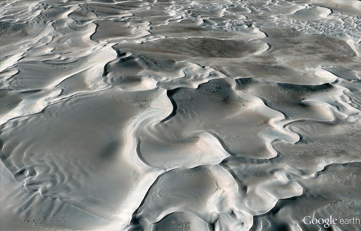
Perspective view of star dunes of Badain Jaran Desert, China
One of my favorite hobbies is scrambling around volcanic sites throughout the western United States, and many of my favorite areas are located in Idaho’s Snake River Plain. Within this river plain, one of the youngest volcanic flow features of the region comprises the Hell’s Half Acre lava flow field. In the aerial image below, taken this past September, you can see “windows” of older river bed material (now farmland) that were not buried during lava flow emplacement.

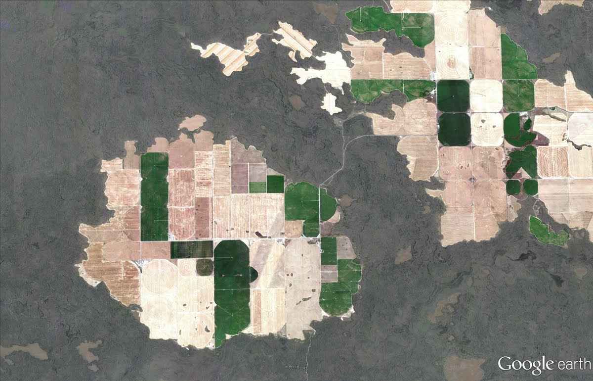
Farmland enclosed by lava flow, Snake River Plain, Idaho
Can you identify the unusual feature relationship seen in the satellite image below? Yes, train tracks cut to the northeast across the airport runway! Those tracks belong to the Kyber Railway, and their two vintage steam locomotives take passengers 42 kilometers to the town of Landi Kotal in Pakistan’s mountainous Kyber Pass.

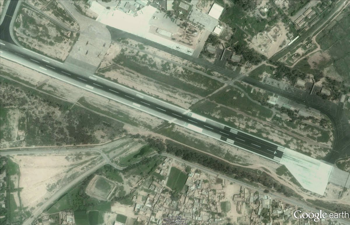
Peshawar International Airport, Pakistan
Below is a fun water sport activity captured in high resolution aerial imagery of the southeastern coast of Auckland, New Zealand. You can see the kayakers paddles as well as the submerged sandbars and boulders of Thorne Bay.

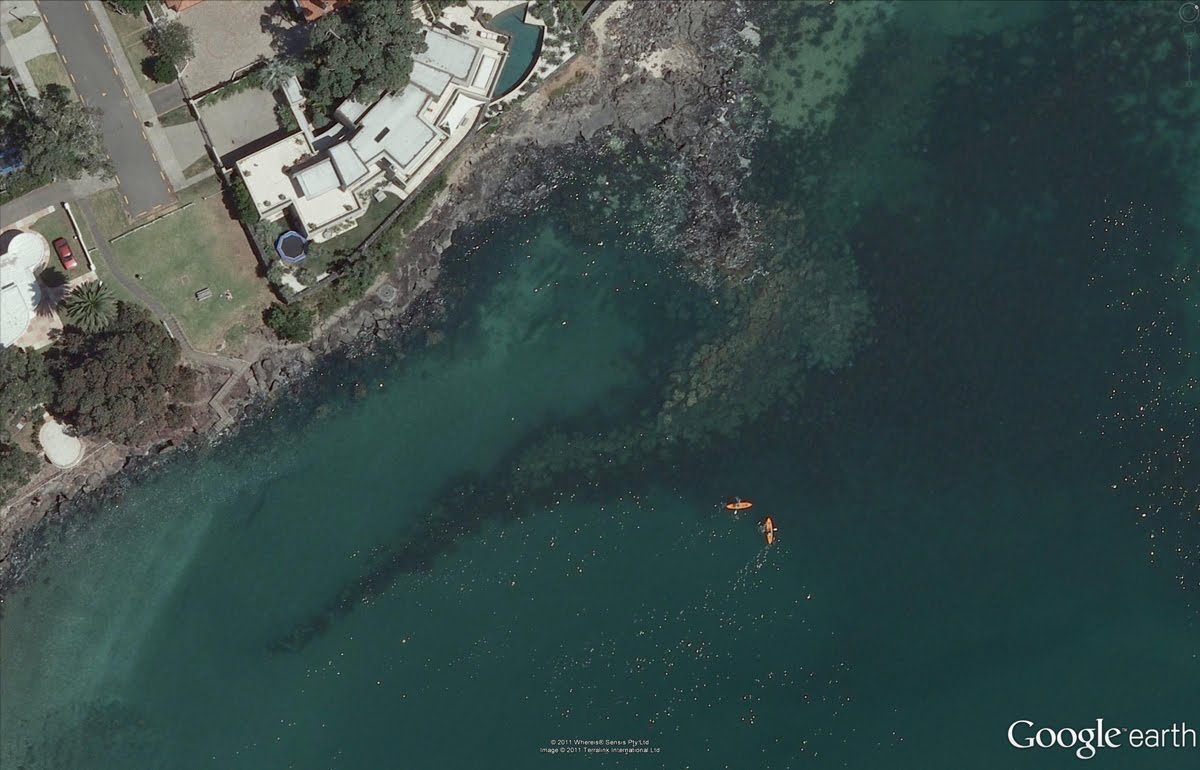
Kayakers in Thorne Bay, New Zealand
We can see the Marmar Palace of Tehran, Iran, a.k.a the Marble Palace in the updated satellite image below. It is associated with the Pahlavi dynasty, and is still used today by the Iranian government.

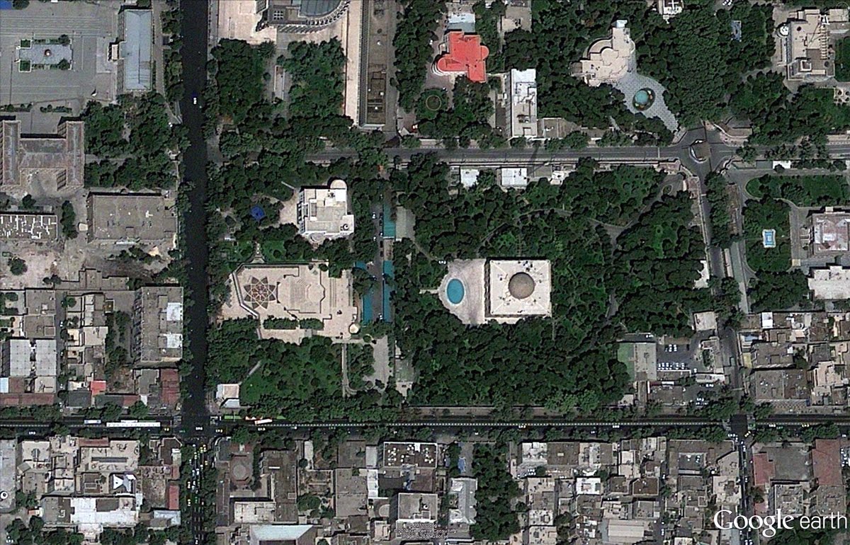
The Marble Palace, Tehran, Iran.
In my opinion, most good things start and end with Elvis references, so our last example showcases updated imagery of Graceland, including the private customized Convair 880 jet Elvis used while hopping across the globe.

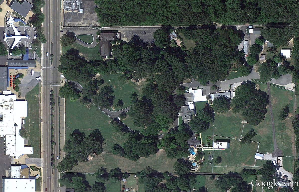
Graceland, Memphis Tennessee
If you’d like to receive an email notification when the Earth and Maps Imagery team updates your favorite site(s), we’ve got just the tool: The Follow Your World application!

These are only a few examples of the types of features that can be seen and discovered in our latest batch of published imagery. Happy exploring!

High Resolution Aerial Updates:
USA: Bellingham, WA; Bemidji, MN; Brookings, SD; Davenport, IA; Emporia, KS; Grinnel, IA; Idaho Falls, ID; Klamamth Falls, OR; Lawrence, KS; Lovell, WY; Nephi, UT; Pittsfield, MA; Portland, OR; San Francisco Peninsula, CA; Scottsbluff, NE; Seattle, WA; St Louis, MO; Terre Haute, IN; Wasco, OR; Williston, ND; Wolf Point, MT

Spain: Huesca, Logrono

Countries/Regions receiving High Resolution Satellite Updates:
Angola, Antarctica, Argentina, Australia, Bahrain, Brazil, Cameroon, Canada, Chad, Chile, China, Colombia, Cuba, Côte d’Ivoire, Democratic Republic of the Congo, Ecuador, Ethiopia, Gaza Strip, Greenland, Hungary, India, Indonesia, Iran, Israel, Jan Mayen, Japan, Jordan, Kazakhstan, Latvia, Libya, Lithuania, Malawi, Mexico, Morocco, Mozambique, Namibia, New Zealand, North Korea, Pakistan, Paraguay, Peru, Philippines, Poland, Romania, Russia, Saudi Arabia, Senegal, Slovakia, South Africa, Spain, Svalbard, Taiwan, Tanzania, The Gambia, Turkey, Uganda, Ukraine, United States, West Bank, Yemen, Zambia, Zimbabwe

The Google Maps API is truly an international product


The Google Maps API is truly an international product with coverage from Hanoi, Vietnam to Lahore, Pakistan and everywhere in between. Like the extensive coverage of Google Maps (thanks in part to user generated edits via Google Map Maker), our developer community is internationally extensive as well! Google developers exist in just about every country and our Google Technology User Groups (GTUGs) have over 253 chapters around the world! To celebrate the global nature of Google Geo APIs and its developers, this month we’ve decided to highlight five great Geo API implementations from developers aus Deutschland! (that’s ‘from Germany’ for non-German speakers :)

Street View Live from Lufthansa

Lufthansa, Germany’s national airline, flies to many destinations in Europe. To help travelers discover Europe and encourage them to plan a vacation, Lufthansa has plotted all their destinations out on a map and linked them to famous spots via the Street View API. For example, by clicking on the Paris icon, users will be taken to Street View imagery of the Eiffel Tower to entice them to travel to the City of Lights.


Bikemap.net, built by Toursprung from Austria and Germany, allows cyclist to view and share bicycling routes from all over the world. Users can rate routes, mark their favorites, send the GPS coordinates to a mobile device, suggest changes to routes, and even share the routes on social media sites. Each route includes details about the distance, surfaces, and difficulty. To help cyclists better understand the terrain the site has an interactive elevation bar. A similar effect can be achieved using the Google Elevation API.

McDonalds Store Locator


The German online destination for McDonald’s features a very nice store locator built on the Google Maps API. Very similar to another store locator built by German company, Hugo Boss, this store locator uses the map as both its background and focal point. The store locator also features custom icons, category filtering (24hr, wifi, drive through, etc), and custom controls.

Mare Verlag – Interactive World Map


Maps become very powerful when they are used to add geo context to information. German magazine, Mare, is using the Google Maps API to geotagged their stories and display them on a map. You can use the map to focus in on a particular part of the world and the application will populate the map with the stories that occurred in that region.

Munich S-Bahn Live Tracking on Google Maps


What’s great about this map is that it shows Munich S-Bahn transit system in real time as the trains travel through the city. There are clickable custom icons for each train, representing their line and when clicked on display stop information in an infowindow. The Google Maps API is a great solution for real-time asset tracking for both transit and business applications. To find out more about using asset tracking for business applications, visit the Google Geo Enterprise website.


Google Map Maker in Pakistan

The month of June proved fruitful for mapping enthusiasts, tech buffs, and entrepreneurs throughout Pakistan as they gathered for a series of Google MapUps organized at universities in three major cities: Islamabad, Lahore and Karachi.

Led by Google Pakistan Country Consultant, Badar Khushnood and a trio of Pakistan’s Map Maker Advocates—Faraz Ahmad, Jabran Rafique and Omer Sheikh—the three events welcomed a total of 150 participants to learn the ins and outs of Google Map Maker. The intent of the MapUps was to guide new users through the process of mapping their cities and neighborhoods while stressing the importance of having a complete map of Pakistan available online.
Recent mapping efforts in Pakistan have been predominantly aligned with relief efforts following Pakistan’s 2010 floods and landslides, as demonstrated by Omer, Jabran and Faraz. Dr. Sayeed Ghani spoke at the Karachi MapUp about Sindh Flood Maps, his community-based geographic information system (GIS) that implements a Google Maps API to assist in disaster management. Dr. Sohaib Khan, who co-hosted the Lahore MapUp, has also focused on flood relief.

On a basic level, the aim of MapUps is to teach new and aspiring mappers the fundamentals of Map Maker, and to bring them together to map their community. Omer explained that “The idea is to get the participants started in the hope that they will continue mapping in the future.” Badar Khushnood and our Mapping Advocates ultimately highlighted the tools and motivation behind mapping, highlighting it as influential, inspirational, and humanitarian.

Google MapUp, NU-FAST, Islamabad, Pakistan
Learn more about hosting a Google MapUp in your own community, and be sure to visit our Advocates and other passionate and helpful mappers in our Map Your World Community.