Earth Knowledge Portal

Earth Knowledge, a well-known information technology firm, has recently released their “Earth Knowledge Portal“, an impressive collection of data that is tied together using the Google Earth Plug-in. The best way to explain what it does is to show you their intro video:

While the site has a variety of different features, the best one is likely their virtual globe. From there, you can view a massive variety of information, including Google Earth Tours, recent earthquakes, geological information, aquifers and rivers, and much more. It’s quite an impressive tool.

earth-knowledge.jpg

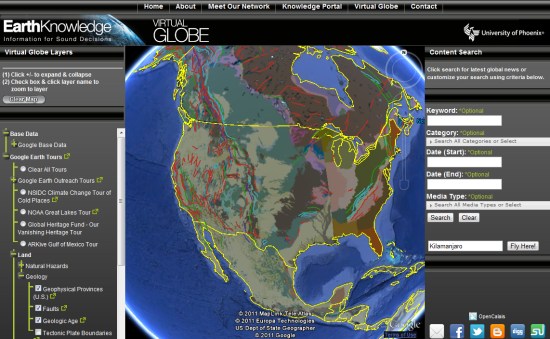
The column to the left side of the earth gives you options to show data overlay/tours, while the column on the right side of the globe includes a powerful search engine, along with a quick “fly here” box to jump to any location on the globe.

Many of the tours were contributed by the Google Earth Outreach Team, and data has also come from sources including BBC Earth, World Wildlife Fund, Reuters, NASA, NOAA, Christian Science Monitor, and the Global Heritage Fund.

Congrats to Earth Knowledge for putting together such a powerful product. Go try out their virtual globe for yourself and tell us what you think of it.

Native Client: Getting ready for takeoff

Over the last few months we have been hard at work getting Native Client ready to support the new Pepper plug-in interface. Native Client is an open source technology that allows you to build web applications that seamlessly and safely execute native compiled code inside the browser. Today, we’ve reached an important milestone in our efforts to make Native Client modules as portable and secure as JavaScript, by making available a first release of the revamped Native Client SDK.

The SDK now includes support for a comprehensive set of Pepper interfaces for compute, audio, and 2D Native Client modules. These interfaces are close to being stable, with some important exceptions that are listed in the release notes.

In addition, we’ve focused on improving security. We have enabled auto-update and an outer sandbox. This allowed us to remove the expiration date and localhost security restrictions we had adopted in previous research-focused releases. Beyond security, we’ve also improved the mechanism for fetching Native Client modules based on the instruction set architecture of the target machine, so developers don’t need to worry about this any more.

We are excited to see Native Client progressively evolve into a developer-ready technology. In the coming months we will be adding APIs for 3D graphics, local file storage, WebSockets, peer-to-peer networking, and more. We’ll also be working on Dynamic Shared Objects (DSOs), a feature that will eventually allow us to provide Application Binary Interface (ABI) stability.

Until the ABI becomes stable, Native Client will remain off by default. However, given the progress we’ve made, you can now sticky-enable Native Client in Chrome 10+ through the about:flags dialog. Otherwise, you can continue using a command line flag to enable Native Client when you want to.

A big goal of this release is to enable developers to start building Native Client modules for Chrome applications. Please watch this blog for updates and use our discussion group for questions, feedback, and to engage with the Native Client community.

Bing engages open maps community

Continuously innovating and improving our map data is a top priority and a massive undertaking at Bing. That’s why we’re excited to announce a new initiative to work with the OpenStreetMap project, a community of more than 320,000 people who have built high quality maps for every country on earth. Microsoft is providing access to our Bing Aerial Imagery for use in the OpenStreetMap project, and we have hired industry veteran Steve Coast to lead this effort.

As a Principal Architect for Bing Mobile, Steve will help develop better mapping experiences for our customers and partners, and lead efforts to engage with OpenStreetMap and other open source and open data projects. As a first step in this engagement, we plan to enable access to Bing’s global orthorectified aerial imagery, as a backdrop of OSM editors. Also, Microsoft is working on new tools to better enable contributions to OSM.

Current OSM editing tools use imagery that is limited in the amount of resolution about the underlying geography (left, center). Bing’s global aerial imagery (right) will enable the OSM community to have access to an unprecedented set of high-quality data, which will enable them to engage in better mapping tasks.

Steve Coast is no stranger to the open community.  He founded OpenStreetMap, a wiki map of the world which anyone can help improve, similar to Wikipedia. Steve also co-founded CloudMade, a company that has supported OpenStreetMap from the early days and which provides an innovative mapping platform and tools which utilize OpenStreetMap. CloudMade is a good example of how the market can benefit from the work of the OpenStreetMap project, and Bing Maps is pleased to join them in the community effort to build better maps.

“We’re pleased to see Microsoft investing in the open map community, and we wish Steve all the best in his new role with Bing,” said Christian Petersen, VP Community, CloudMade.

We are looking forward to working with the OpenStreetMaps community to help deliver even better maps for people around the world.