New labels in Google Earth


Google has just made some subtle changes to the way the “borders and labels” layers behave, but it makes them a lot more useful.

Back in April, Google made some great changes to the Mountains layer that included new photos, video tours, cross-section views and more. They’ve now added more items to that layer, including mountain ranges, deserts and plains.

The best new addition is the mouseover extents for each of these areas; hover over the name of a mountain range or desert, and the area of that item becomes outlined in Google Earth. For example, here are the Blue Ridge Mountains in the eastern United States.


blue-ridge.jpg 

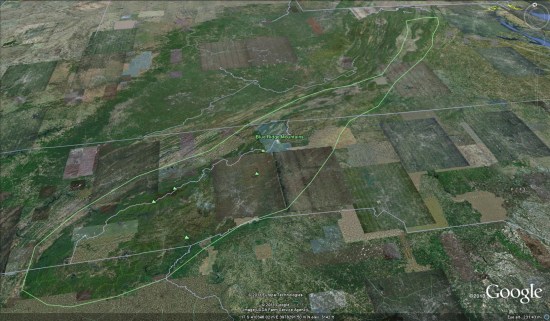
Google has also allowed for items to be nested, when appropriate. Using the example of the Blue Ridge Mountains, you can zoom out and hover on the Appalachian Mountains label and notice that it covers the entire area of the Blue Ridge Mountains (and a lot more).

As I found myself browsing around the globe looking at various items, I realized that this was another great little piece that helps make Google Earth useful in educational settings. StrataLogica,  certainly adds a lot of data to Google Earth, but this is a simple way to make exploring those areas more useful.

(via Google Lat Long Blog)

South Sudan is on the map!


A few weeks ago, South Sudan became the 193rd country on the planet, but that wasn’t reflected in Google Earth until now. Stefan at Ogle Earth made some interesting comments about it when the new country was introduced, including:

• Why wasn’t Google ready for it from day one?

• What will they do about the disputed border areas?

They delay may have been so Google could sort out the border issues. As Stefan suggested, Google has included a red border on parts of the country to indicate the disputed borders, as seen here:


south-sudan.jpg 

The red area on the center of the northern border of South Sudan is Abyei, which right now belongs to both Sudan and South Sudan. However, I’m not sure of the story on the red disputed area along the western border.

To see the new country for yourself, simply search for “South Sudan” in Google Earth and it will fly you directly there.

Google Earth Imagery – July 16


Thanks to sharp-eyed GEB reader ‘Andy’, we see that Google has just pushed some fresh imagery into Google Earth. It’s been a longer delay than we normally see between updates, but it looks like it might be a fairly substantial one!


crete.jpg 

As is usually the case, you can use Google Maps to determine for sure whether or not a specific area is fresh. This new imagery isn’t in Google Maps yet, so you can compare Earth vs. Maps to see what’s new; the fresh imagery is already in Google Earth, but the old imagery is still in Google Maps. If you compare the two side-by-side and they’re not identical, that means that you’ve found a freshly updated area in Google Earth!

[UPDATED – 16-July, 11:417am EST]

  • France: Autun, Morhange
  • Germany: Picher, Rastow, Samerberg, Wobbelin
  • Greece: Chametoulo, Ierapetra, Kymi, Santorini Island
  • Mexico: Various — thanks ‘augusto’
  • Poland: Lanieta
  • Romania: Various — thanks ‘twist3r’ and ‘spiderpc’
  • Spain: Aranda de duero, La Carolina
  • United States: Idaho (Boise) and New York (Manhattan, Syracuse) — thanks ‘AndreasK’ and ‘Jonas’