A few weeks ago, South Sudan became the 193rd country on the planet, but that wasn’t reflected in Google Earth until now. Stefan at Ogle Earth made some interesting comments about it when the new country was introduced, including:
• Why wasn’t Google ready for it from day one?
• What will they do about the disputed border areas?
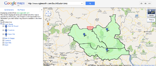
They delay may have been so Google could sort out the border issues. As Stefan suggested, Google has included a red border on parts of the country to indicate the disputed borders, as seen here:
The red area on the center of the northern border of South Sudan is Abyei, which right now belongs to both Sudan and South Sudan. However, I’m not sure of the story on the red disputed area along the western border.
To see the new country for yourself, simply search for “South Sudan” in Google Earth and it will fly you directly there.