A great guide to Turkey in Google Earth

Following in the footsteps of great sites such as 3DHawaii and 3DLasVegas, we travel to the other side of the globe to check out 3DLocationEarth, set in Turkey.

The basic idea of the site is similar the concept behind the Hawaii and Las Vegas sites; provide information about area hotels, businesses, schools, etc, and “fly” the user to each place using the 3D map on the screen.

turkey.jpg

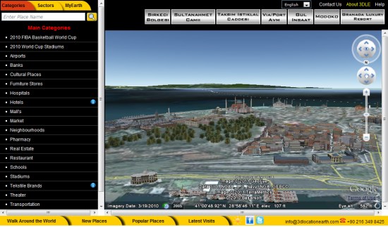
Note: When the site first loads, all of the text is in Turkish. To convert, find the “language” drop-down near the top-right corner and select “English”.

While the amount of content on this site is quite impressive, it’s a bit clunky to use when compared to sites like 3DLasVegas. The Vegas site, if you recall, has a slick “Location Navigator” at the bottom of each item to help you easily explore it in 3D. This site has similar icons at the top of the page, but they’re very inconsistent. I suppose that’s part of the issue when dealing with such a large dataset. In addition, 3DLasVegas has thumbnails of all their locations on the left site, whereas 3DLocationEarth simply has a text-based list.

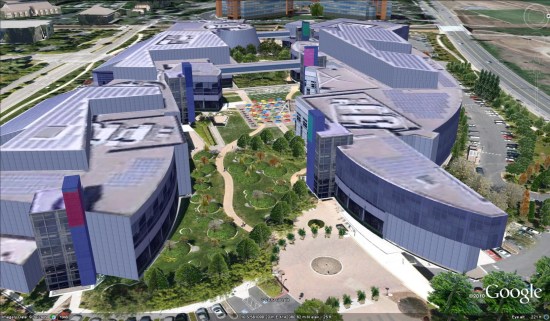
However, what is truly amazing is the 3D content that 3DLocationEarth has contributed to the 3D Warehouse, and therefore to Google Earth. As of right now, they have nearly 3400 models in Google Earth, including some notable items such as the Google headquarters in Mountain View, CA!

google.jpg

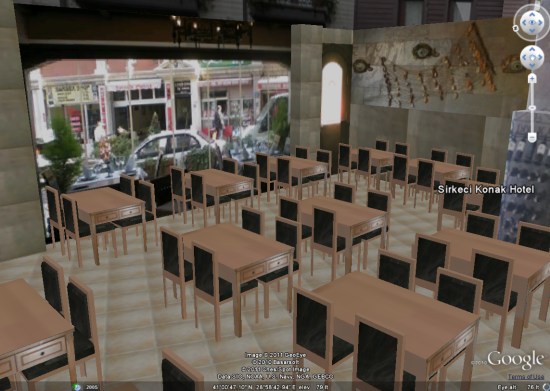
Even more impressive is their ability to view inside of various buildings. A great example of that is the Sirkeci Konak Hotel. Once you load that page, play with the silver icons at the top to go to the lobby, various rooms, the pool, etc.

We’ve shown you a few 3d interiors before, but this hotel is quite remarkable.

sirkeci.jpg

It will be interesting to see which direction Google pushes going forward. While the interior of this hotel feels similar to the Street View-based art gallery interiors that Google released earlier this week, they’re vastly different technologies. You would think that a single method for creating interiors would be ideal, but we may be a few years away from that.

In any case, check out 3DLocationEarth to see all of the great work these guys have done.

The 2011 GSA Penrose Conference

Last week, at Google’s Mountain View headquarters, a group of 74 professors and students met for a Geological Society of America Penrose Conference to discussVisualizing the Possibilities for Geoscience Education and Research“.

Penrose_group.jpg

While the event was hosted at Google, and the Google folks certainly helped with logistics, the event was run by members of the geospatial community, for the purpose of discussing the role of Google Earth in higher education and research.

The week provided a wealth of ideas and information, such as Barb Tewksbury’s discussion of geologic map interpretation and John Bailey and Sean Askey’s presentation about generating tours from lines.

For a quick look at what the conference was like, Eugene Potapov shot this brief video:

To learn more about the topics discussed at the conference, your best resource for now are the blogs of Rich Treves and Meg Stewart, as they’ve both posted a lot of great information from the week. The official site should be updated soon with more detail about each presentation.

All in all, it sounds like it was a very educational week. Were any of you among the attendees? Leave a comment and let us know what you thought of the conference.

Search your geo data using spatial queries from Fusion Tables!

I’m Kathryn Hurley, a Developer Programs Engineer for Fusion Tables, and I have to say, I really dig Fusion Tables. The power it gives you to visualize your data is amazing! Plus, the team is working hard to add new features that give even more power to you, the developer.

It is my pleasure to announce that Fusion Tables now offers spatial queries! Using spatial queries, developers can (1) find all features that are located within (or overlap with) a given distance from a location (2) find all features that are located within (or overlap with) a given bounding box, and (3) find a given number of features closest to a location.

To demonstrate some of the new syntax, let’s go through a potential use case of spatial queries: creating a store locator map. For this demo, I set up a table in Fusion Tables, 297050, containing the locations of a fictitious pizza restaurant chain in the San Francisco bay area. The table contains the name, location, and whether or not that location delivers.

Now let’s say we want to display all the restaurants that fall within a bounding box. To do so, use the syntax:

SELECT * FROM 297050 WHERE ST_INTERSECTS(Address, RECTANGLE(LATLNG(37.2, -122.3), LATLNG(37.6, -121.9)))

The map to the left shows this query in action using the FusionTablesLayer. The example shows all rows in the pizza table that fall within the bounding box specified with a lower-left coordinate of 37.2, -122.3 and a upper-right coordinate of 37.6, -121.9.

This is the code for the FusionTablesLayer:

map = new google.maps.Map(document.getElementById('map_canvas'), {
   center: new google.maps.LatLng(37.4, -122.1),
   zoom: 10,
   mapTypeId: google.maps.MapTypeId.ROADMAP
});
tableid = 297050;
layer = new google.maps.FusionTablesLayer(tableid, {
   query: "SELECT Address FROM " + tableid + " WHERE ST_INTERSECTS(Address, RECTANGLE(LATLNG(37.3, -122.3), LATLNG(37.6, -121.9)))",
   map: map   
});

We can also find the 10 features closest to a particular coordinate, such as the latitude, longitude coordinate of your house or a major city center. To find the 10 nearest features to Mountain View, CA at coordinate 37.4,-122.1., we use the syntax:

SELECT * FROM 297050 ORDER BY ST_DISTANCE(Address, LATLNG(37.4, -122.1)) LIMIT 10

These 2 examples demonstrate how to create a store locator-like map, but the possibilities are endless! You could create an application that finds the most popular bike trail routes in your area or enable crowd sourcing to identify roads that might need more street lamps.

To learn more about the full spatial query offering in Fusion Tables, please see the Fusion Tables documentation. You can also join the Fusion Tables User Group to receive announcements about new features or post questions you might have about Fusion Tables. Or follow us on Twitter: @GoogleFT. And, most importantly, have fun creating awesome apps!

Posted by Kathryn Hurley, Google Geo Developer Relations