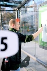
Today sees the launch of our latest collaboration via the Tales of Things project – this time with a Norwegian transport company, Kolumbus. Tales of Things has been utilising Kolumbus’ already existing QR codes to allow passengers to leave stories for one another. When a passenger visits one of Kolumbus’ more than 4,000 bus stops they will find a QR code which when scanned with the free Tales of Things’ app on with the iPhone or Android it will not only link them to timetable information, but also allow them to leave a message on the bus stop.
Each stop contains a unique code, so the timetable information and tales are site specific. Through tales of things, passengers can leave messages about experiences they have had in the area, anecdotes about places they are going, leave a message for a loved one or maybe leave a treasure trail for your friends. In addition to this, each time a bus stop is scanned, it ‘tweets’ to the world that a new story, message or memory has been left.
 In essence we think of this as a mix of Facebook and FourSquare for Bus Stops, where users leave behind stories, messages and memories while at the same time seeing when the next bus is.
The things can be geo-located through an on-line map of the world where participants can track their object even if they have passed it on. The object can also update previous owners on its progress through a live Twitter feed (which is unique to each object entered into the system).
Einar Hougen, project manager in Kolumbus, states: “When we learned about this exciting UK research project, we instantly recognized the parallels to our own QR tagging of bus stops, which we believe is the largest adaptation of QR codes of this kind in Norway to date. Scanning a QR code at a Kolumbus bus stop gives instant access to current departure times, right on your mobile phone.
In Kolumbus, we are happy to support this research project by sharing our QR mechanism and allowing all our bus stops to be accessible in the tales of things world of objects. Via our tech blog, next.kolumbus.no , we know there are many tech savvy users among our travellers. This will give them the opportunity to join this project, -and hopefully have a bit of fun at the same time!”
ABOUT KOLUMBUS
Kolumbus is the public transport company for Rogaland county, Norway, serving the public with bus and high speed boat routes in the areas of Stavanger, Haugesund, the Fjords, Dalane and Jæren.
For more information on Kolumbus visit http://www.kolumbus.no/
http://next.kolumbus.no/2011/02/04/talesofthings/ and of course you can tag your own objects, places, spaces or bus stops via Tales of Things.