Mapping one of the biggest road races in 3D

The BolderBOULDER is one of the United States’ biggest 10K road races. Last year, more than 54,000 people participated, including several members of the SketchUp team and plenty of other Googlers from the Boulder office—after all, it’s right in our backyard.

Back in January, a group of us met with the race’s organizers to figure out ways that our geo-technology might play a role in this great local tradition. Our team ended up putting together a couple of nifty 3D maps that should help everyone (runners and spectators) get their bearings ahead of race day on May 30th:

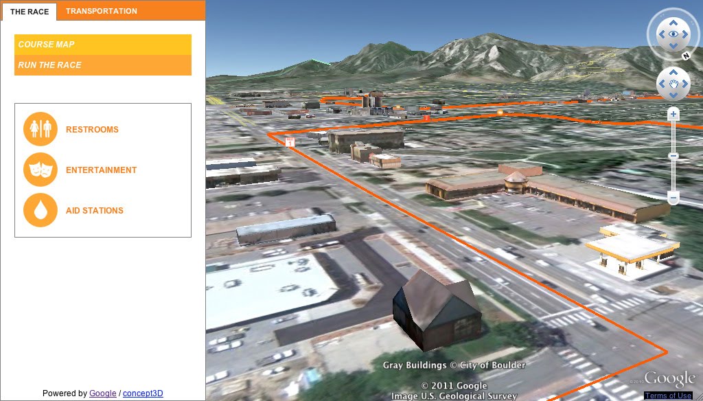
The 3D Course Map lets you preview the race route in Google Earth.
We used the Google Earth API to embed an interactive course map on BolderBOULDER’s website. With the Google Earth plug-in installed, you will be able to see hundreds of 3D models of the buildings along the course, as well as special race day structures we modeled just for the event. Be sure to click “Run the Race” (in the upper-left corner of the screen) to take a guided tour of the course.

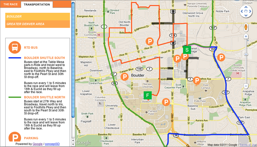
The Transportation Map provides information about getting to the race.
To help folks get to and from the race, we used the Google Maps API to embed a map with information about public transportation options, road closures and parking.

Whether you’re planning to join us in Boulder or just perusing the course from afar, feel free to explore the maps we built. No running shoes required, and no one’s keeping time.

Introducing Voice Search for Indonesian, Malaysian and Latin American Spanish

We are excited to announce the launch of Voice Search in Indonesian, Malaysian, and Latin American Spanish, making Voice Search available in over two dozen languages and accents since our first launch in November 2008. This accomplishment could not have been possible without the help of local users in the region – really, we couldn’t have done it without them. Let me explain:

In 2010 we launched Voice Search in Dutch, the first language where we used the “word of mouth” project, a crowd-sourcing effort to collect the most accurate voice data possible.The traditional method of acquiring voice samples is to license the data from companies who specialize in the distribution of speech and text databases. However, from day one we knew that to build the most accurate Voice Search acoustic models possible, the best data would come from the people who would use Voice Search once it launched – our users.

Since then, in each country, we found small groups of people who were avid fans of Google products and were part of a large social network, either in local communities or on online. We gave them phones and asked them to get voice samples from their friends and family. Everyone was required to sign a consent form and all voice samples were anonymized. When possible, they also helped to test early versions of Voice Search as the product got closer to launch.

Building a speech recognizer is not just limited to localizing the user interface. We require thousands of hours of raw data to capture regional accents and idiomatic speech in all sorts of recording environments to mimic daily life use cases. For instance, when developing Voice Search for Latin American Spanish, we paid particular attention to Mexican and Argentinean Spanish. These two accents are more different from one another than any other pair of widely-used accents in all of South and Central America. Samples collected in these countries were very important bookends for building a version of Voice Search that would work across the whole of Latin America. We also chose key countries such as Peru, Chile, Costa Rica, Panama and Colombia to bridge the divergent accent varieties.

As an International Program Manager at Google, I have been fortunate enough to travel around the world and meet many of our local Google users. They often have great suggestions for the products that they love, and word of mouth was created with the vision that our users could participate in developing the product. These Voice Search launches would not have been possible without the help of our users, and we’re excited to be able to work together on the product development with the people who will ultimately use our products.

Act Locally with New Imagery & Maps in Sudan

After years of conflict, Southern Sudan overwhelmingly opted to secede from the country’s north. Many challenges lie ahead as the newly independent state negotiates the rocky path towards independence. We believe that access to high-quality, up-to-date and locally relevant maps will assist humanitarian organizations working in the region.

We are encouraging users to add their local knowledge to this mapping effort through a campaign to build a better map of Sudan. Recent satellite imagery is key to building up-to-date maps, and we are continuously acquiring fresh and historical imagery of Sudan. Our latest imagery update is now live on Google Map Maker, Google Earth, and Google Maps, with nearly fifty percent of the UN priority areas over Southern Sudan covered with high resolution imagery. Thanks to our satellite partner GeoEye, we will continue to acquire and publish high resolution imagery of the remaining UN priority areas, as well as to refresh areas that we have previously covered as the need arises. This new imagery, such as the one over Melut, will directly benefit the many organizations working in Sudan and ultimately support the building of a solid basemap of Sudan to achieve long-term socioeconomic objectives.
Town of Melut (before 2/16/2004, after 1/30/2011). In Melut, there is a humanitarian hub where many services are delivered to at risk populations, including food, water, health care, education, and more. Given the varying needs of each of these services, maps can provide a variety of planning benefits for expansion, staff safety, and emergency procedures.
Google is also contributing to various humanitarian efforts, including the Satellite Sentinel project, by helping to build an active and self-sustained Sudanese mapping community — locally and among the Sudanese diaspora. This community will help improve maps of Sudan by using Google Map Maker, a product that combines the power of mapping with community engagement.
Dedicated mappers have started building the foundation for a Sudan mapping community, resulting in high quality maps of Sudan. But this is a long term process that requires deep commitment from various stakeholders and community groups. To join the Sudan mapping efforts, and offer feedback, please join our Sudan community mailing list or visit our team site.