Loughborough University Campus Map
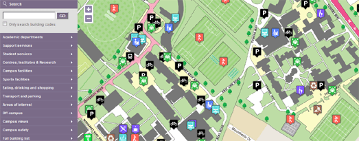
Loughborough University’s campus map is a great example of how to use the Google Maps API to help students and visitors find their way around a large campus.
The map uses the custom overlays function to overlay a custom map of the university on top of the Google Map. The custom map overlay includes features and locations that are not on Google Map’s own map tiles, such as trees, tennis courts, football pitches etc.
The map also makes good use of polygons to make buildings on the map interactive. If you click on any of the buildings you can view the building’s name, a photo of the building and links to its page on the university’s website.
Finally, the map includes a very nice search facility that allows you to search for a building or feature by name or by category.
Greenpeace – Moscow Recycling Map
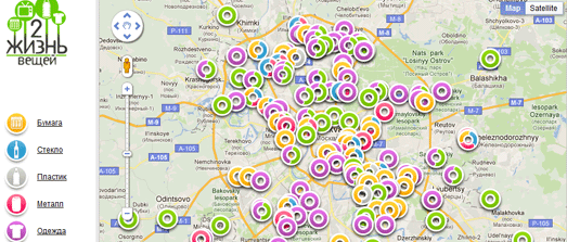
Greenpeace has released a Google Map of recycling stations in Moscow.
The map shows the locations of recycling stations for paper, glass, plastic bottles, old electronics and clothing in the Russian capital. The map includes custom made markers that are colour coordinated to indicate the type of recycling possible at each station.
It is also possible for users to add the location of missing recycling locations to the map.
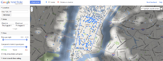
Google has today launched Hotel Finder, a new search tool to help you find a hotel.
The tool includes an interesting Google Maps interface that allows you to search for hotels by location. When you enter a location into the Hotel Finder the map shows an initial shape based on the most popular area for visitors to stay. Users can drag the shape to define more closely this area, e.g. close to the ocean or along Sunset Boulevard.
Hotel Finder also shines a “tourist spotlight” on the most visited areas in the selected city. Tools in the sidebar allow you to adjust the price of hotels you wish to view on the map and to compare the current price to the hotel’s typical price.
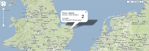
Online clothes retailer Zappos started a trend when they created their live Zappos Map. This real-time map was created to show the latest orders placed on Zappos live on a Google Map.
The Zappos Map was quickly followed by Net-a-Porter Live, ThisNext and The Book Depository Live. Now Livebookings, Europe’s largest online booking service for restaurants, has released a live map of restaurant tables booked by its customers.
Livebookings Live takes the reservations coming in, removes the customers’ names, and plots them on a map showing where, for how many, and with what frequency the Livebookings system is used.
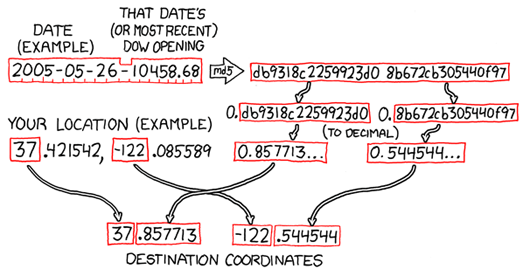
The xkcd Geohashing Wiki is inviting you to participate in the wonderful world of random location meet-ups.
Geohashing is a method for finding a random location near your current location and then visiting it. Every day the geohashing algorithm generates a new set of coordinates for your location. Everyone in a given region gets the same set of coordinates.
After you have visited the random location you can document your expedition on the Geohashing Wiki, including details of who was involved in your expedition and pictures of your adventure.
To get your daily randomised coordinates visit the Geohashing Google Map. Click on the map to show your location and, using the geohashing algorithm, your random location will be generated by the map.
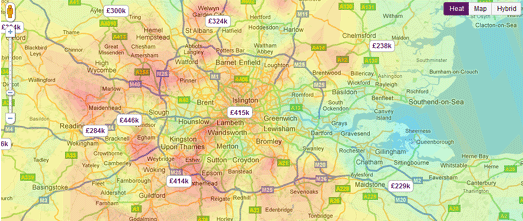
Real-estate website Zoopla has created a heat-map of UK property prices.
The Google Map provides a quick overview of where properties are affordable and where houses are more expensive. For example if you zoom in on London, you can see a distinct pattern of expensive property in the commuter belt around the capital.
World Tour Schedules on Google Maps
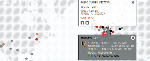
Artist / DJ Richie Hawtin has created a gorgeous looking Google Map for his current world tour. Custom map tiles have been used to give the map a distinct design. The dot-matix look of the design is continued in the custom made map markers and information windows.
Dates on the tour are displayed on the map and a slide-out sidebar shows the dates in list form.
The ‘One City’ world tour continues until December.
