New 45° imagery available for 35 more cities

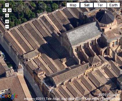
In Córdoba, the third largest town in the Spanish region of Andalucia, you can now explore in highly resolved images from four directions. Check out the world famous Mezquita-Catedral, a former mosque from the times when that part of Spain was ruled by the Moors, now a Roman Catholic Cathedral. Its construction as a mosque began around 800 and it was turned into a church after 1200.


View Larger Map


A major update in the U.S. comprises Houston, the largest city of Texas and fourth largest of the United States. Take a look at the Houston Ship Channel with all its refineries and oil tanks alongside, erected for one Million Dollars in 1902 when oil was first discovered in the area.

View Larger Map


If you like sports you’ll be interested in the Rice University’s athletics stadium west of downtown or the Toyota Center, used by the Houston Rockets basketball and the Houston Aeros hockey teams.

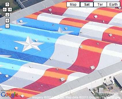
Or take a look at William P. Hobby Airport just southeast of the city center which was the former main hub even for international flights. Nearby the largest American flag can be seen on top of a building.


View Larger Map


Full list of updated cities:

Augsburg, Germany. Barstow, CA. Bartlett, TX. Big Bear, CA. Blackstone, VA. Catalina Foothills, AZ. Córdoba, Spain. Delano, CA. Desert Hot Springs, CA. Richmond, VA. Elgin, TX. Healdsburg, CA. Helendale, CA. Hemet, CA. Houston, TX. Mendoza, Argentina. Midlothian, VA. Napa Valley, CA. New Braunfels, TX. Ojai, CA. Ottawa, Canada. Pensacola, FL. Porterville, CA. Plant City, FL. Rancho Del Lago, AZ. Rosario, Argentina. Santa Clarita, CA. Sarasota, FL. Taylor, TX. Temecula, CA. Treasure Island, CA. Troy, IL. Twentynine Palms, CA. Wakefield, VA. Yucca Valley, CA.
Google Earth is showing projections of forest dynamics

While Google Earth is often used to show past and present conditions on Earth, it’s rarely used to see the future. We’ve seen cool sites like the Blue Marble 3000 and the University of Corsica’s ForeFire, but most focus on showing what we know about right now rather than showing what could happen in the future.

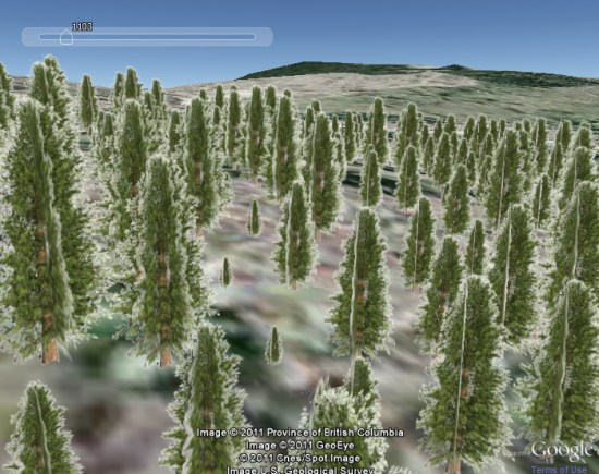
That brings me to Michael Gerzon and his neat idea to use Google Earth to show projections of forest dynamics, both in terms of tree growth and the spread of potential forest fires.

forest.jpg

On his site, you can run a few sample demos to see how things work. It’s not using real GIS data at this point, but it’s a neat demonstration and I think it’s the first I’ve seen that shows tree growth in an area.

Expanding the idea out, there are some fun possibilities. For example, you could show what an area would look like after xx years of tree growth, maybe in a new housing development. Combined with 3D buildings, it could be very powerful.

Building 3D Agent-Based Models for Urban Systems

Number 161 in the every growing CASA Working Paper Series is Building 3D Agent-Based Models for Urban Systems by A.T. Crooks, A. Hudson-Smith and A Patel in a collaboration between George Mason University, United States of America and here at Centre for Advanced Spatial Analysis (CASA), University College London.


There is a growing interest in relating agent-based models to real- world locations by combining them with geographical information systems (GIS) which can be seen with the proliferation of geosimulation models in recent years. This coincides with the proliferation of digital data both in the two and three dimensions allowing one to construct detailed and extensive feature rich and highly visual 3D city models. This paper explores some of these developments in relation to our own initial work on building 3D geospatial agent-based models of urban systems and the technologies that allow for such models to be created. Furthermore, we highlight some techniques for the creation of 3D agent-based models and stress that such models are not a substitute to good models.


The intention of this paper is to explore the recent advances in computer technology, software and associated techniques that allow for the creation of 3D agent-based models which can be used to simulate various aspects of city life focusing on our own initial research of creating 3D cityscapes and 3D agent-based models. The remainder of this paper will therefore explore our attempts to use digital data to create feature rich 3D cityscapes (Section 2), discuss why such cityscapes are important for ABM (Section 3), before moving into how advances in computer hardware allow for the creation of 3D agent-based models (Section 4); we then briefly explore a potential application domain, that of pedestrian modelling (Section 5). Section 6 presents techniques which we are currently utilizing to create 3D agent-based models through various linking and coupling approaches along with advantage and disadvantages of each approach before a discussion is presented (Section 7).

Download the full paper (748k pdf).