Google Earth offline

One of the neat snippets in Google’s recent blog post about training environmental journalists was that they’re now using the Google Earth Portable Server in real-world environments, though still in a closed trial.

Google has always been very responsive when disasters strike, and the Portable Server could allow them to assist to an even larger degree. The Portable Server allows you to pre-load data from selected areas so that you’re still able to access that data even if you enter an area with no internet connection, as is common after a disaster of any kind (flood, hurricane, tornado, etc).

Google explains it in further detail on this site, but their basic information states:

With the Google Earth Enterprise Portable solution your users can select and download portions of your private globe which they can serve and access locally from their laptop. Whether fighting fires or taking off in a plane, the Google Earth Enterprise portable gives your users the Google Earth experience when they are not connected to the Internet.

The portable solution consists of:

• A simple user interface to the Google Earth Enterprise system enabling users to extract portions of a globe based on a user-defined area of interest.
•A light-weight, cross-platform server that serves the extract globe on an end users machine.

For more information about Portable Earth Enterprise, visit the Google Earth Enterprise site or watch the short video below.
Google Maps Sneek Peek

Search – Google Maps Sneek Peek
*Google are testing and this may not be available to all web users…

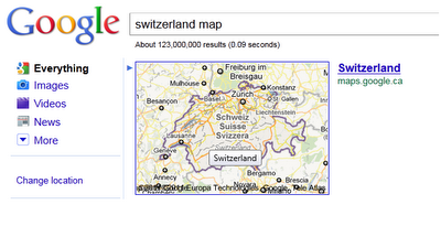
Highlight the map area of interest by search.
Switzerland Map Box Boundary
Useful for Countries, Administrative, City Limits and even Islands.

Great for people who are looking but don’t necessarily now the shape or administrative regions Zipcodes in the US, Postal Codes in Canada (but not UK postcode sectors).

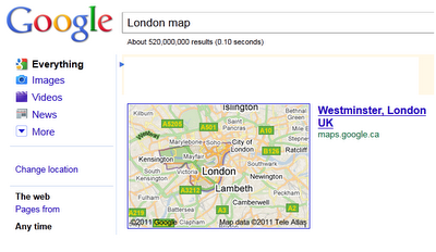
Google are testing a highlighting method for the users search
London Map Box Boundary
London (Westminster London) is automatically highlight when users do a search on google.com

sources:
http://searchengineland.com/google-adds-zip-code-outlines-to-map-one-box-77733
http://googlesystem.blogspot.com/2011/05/google-maps-onebox-outlines.html

Secrets and Surprises in Geo APIs Summer Learning Series

The second session of the Geo track at Google I/O was “Secrets of the Surprises of the Google Geo APIs.” Going into I/O we wanted to have a session that could serve as a foundation for later sessions and one where we can feature some of the latest launches leading up to Google I/O. We covered features of the Maps API v3, the Earth API, Fusion Tables, the Maps API Web Services and the Static Maps API in this one session.

What we hope that you take away from this talk is that there is more to the Maps API than just putting markers on a map – we’ve been actively adding many cool features that can really enhance your mapping application and create a better experience for your users.

Here’s a small subset of the features discussed in the talk:

  • With an ever-growing list of cities with 45° imagery available you’re now able to give your users a new perspective of what a place looks like.
    Don’t forget that there are several easy to enable layers available to quickly add content to your map.
  • Developers have frequently requested the ability for API applications users to drag direction routes around the map in a similar manner to Google Maps, so as you might have guessed, enabling draggable directions in the Maps API is now as simple as a one line code change.
  • A favorite feature of the Maps API is the ability to style the base Google map. With the power to change not only the features shown on the map but the color scheme of those features you have tremendous ability to theme your map to fit a look or brand or remove features that are relevant to your users.
  • Street View in the Maps API v3 is implemented entirely in HTML and Javascript so it’s usable on mobile devices with capable browsers without the use of a plugin. This also gives you the power to provide your own custom panoramic imagery and link it to our standard Street View imagery. Don’t let the experience end at the front door – take your users indoors!
  • We’ve added a Distance Matrix service that lets you quickly and easily get travel time and distance between many origins and destinations in one call.
  • In addition to providing driving, walking and bicycling directions the directions service will even optimize the route, determining the best order to visit several destinations.

We talked about a lot more – including AdSense integration, the Places API, useful open source libraries, Fusion Tables and historical imagery, trees and 3D buildings in the Earth API – check out the video or review the slides to learn more!