The Bing Maps Webcasts Now Open for Registration

The Bing Maps Platform from Microsoft enables organizations to easily and cost-effectively deliver geospatial content to the customers and businesses they serve. Not only does this optimize existing investments in GIS and imagery services, it allows organizations to save money using Bing Maps by making strong connections with customers and exposing relevant content easily on a map from Bing.

Register today to attend a webcast and learn more. Topics include:


What’s New in the Bing Maps Platform?  | February 16, 2012, 2pm Eastern time, 60-minutes

Attend this session for an overview of the latest capabilities in the Bing Maps Platform. You’ll learn the latest on the Bing Maps Imagery program, how to view the meta data and other features in the platform including the best portal to see the latest new imagery sets.


Using the BingMapsPortal.com and keys with Bing Maps Platform | March 15, 2012, 2pm Eastern time, 60-minutes

Attend this session and learn how to use the bingmapsportal.com, tips for using/hiding your Bing Maps key and other helpful development hints.


Bing Maps Spatial Data Services | April 19, 2012, 2pm Eastern time, 60-minutes

Attend this session and learn how to take advantage of the Bing Maps Spatial Data Services included with the Bing Maps Platform for data hosting and findnearby/bound box queries.
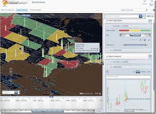


How to show and manage organizational data Webcast

You can join for a webcast that will demonstrate how governments—federal, state, and local—are empowering their constituents with access to organizational data in captivating interactive data visualizations. The webcast will air on Wednesday, June 8, at 1:00 P.M. Eastern Time.

RetailAnalyzerVF5

During the webcast, special attention will be paid to how public sector organizations are turning SharePoint into a geospatial business intelligence engine to gain clearer understanding more quickly, make better decisions faster, and keep their citizens safe. The webcast will offer live demonstrations that show how organizations of all sizes are leveraging the geospatial and time attributes of their data to unite enterprise content, relevant web feeds, mobile device inputs, images, and more into a single view, resulting in speedier decisions, more efficient use of resources, and reduced overall spend.


While everyone is invited to attend, you should definitely attend if you are a:

•    Program manager
•    GIS professional
•    IT professional
•    Anyone looking to make their data available to a wider audience

Presenters:
•    Matthew Pietryszyn, GIS Coordinator, City of Brampton, Ontario
•    Jim Keenan, VP of Government Sales, IDV Solutions

Webcast recording showcases what’s new with Bing Maps

Bing Maps developers from Earthware, OnTerra and Infusion recently discussed Bing Maps’ latest features and development tips and tricks. The webcast aired on March 1, and is now available as a recording here<http://www.microsoft.com/maps/>.

During this fast-paced, 40-minute overview of the new Bing Maps AJAX Control 7.0, panelists discuss how to evaluate and improve the performance of Bing-powered mapping applications and new tools for working with SQL databases.

Earthware’s Brian Norman showed developers how to get maximum performance and speed from the Bing Maps AJAXAPIs. 2010 King of Bing Maps Ricky Brundritt – developer of the TaxiFare Calculator – demonstrated how to create mapping add-ons that enhance any mapping application. Rounding out the panel, OnTerra’s Steve Milroy highlighted the new DataConnector, which allows organizations and developers to rapidly create web mapping applications that contain rich geospatial data visualization features.