A few weeks ago, we showed you a recent case of an “armchair archaeologist” who used Google Earth to discover almost 2,000 archaeological sites in Saudi Arabia.
With more and more stories like this popping up in the past few years, GEB reader “Will from the UK” has built a slick tool to help with the process.
In his words:
I enjoyed your post about the archaeologist who found interesting artifacts in Saudi Arabia using Google Earth. It got me thinking about how to do a systematic search of an area using GE.
There are no tools in GE that help, other than the usual lines / placemarks. Marking an area out using lines is fairly tedious. A grid is a useful solution. I have seen grid generators online, but they tend to come and go, and you need to be online to use them.
I have created a spreadsheet that generates the KML code for a Latitude / Longitude grid. A grid allows a more systematic search to be conducted and also allows more people to take part in a search – the work can be divided between many volunteer searchers.
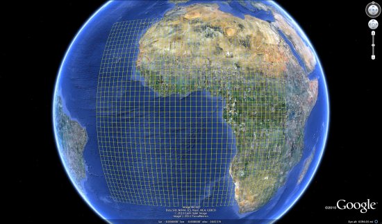
The resulting spreadsheet is quite impressive, and it is a great way to divide up a large area for more precise searches.
You can download the Excel-based spreadsheet here. The spreadsheet is remarkably powerful, though it has a bit of a learning curve and a few limitations. Fortunately, Will has been generous enough to develop a User Guide (PDF) to help you get started.