The Thailand Floods


As Google often does during disasters (such as the Gulf Oil Spill and the Japan Earthquake, Google has set up a Crisis Response page to help provide information for those trying to assist with the flooding in Thailand.

The flooding has become quite devastating and more widespread than most people realize. From Google’s page:

Thailand is currently facing its worst flooding in 50 years. Flood waters have swamped more than two-thirds of the country, submerging rice fields and shutting down hundreds of factories while over 900,000 families and businesses have been impacted and hundreds of lives have been tragically lost. National relief efforts are now focused on providing essential food, clean water and shelter to displaced people and restoring damaged infrastructure to the Kingdom of Smiles.

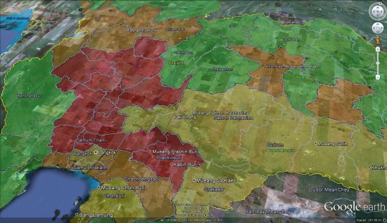
You can use the map on their page, or download various elements as KML files to be able to browse them in Google Earth. For example, here is the “Flood affected areas across Thailand” map (KML), which gives you a quick glance at the hardest hit areas.


flood-affected.jpg 

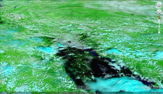
For fresh satellite imagery of the area, you can use the imagery released by the NASA Earth Observatory a few days ago. You can view the image on their site.


thailandimagery.jpg 

Google Maps Mania

Geo Sitemap Generator’s New Features

The “grand daddy” of geo sitemap generators has recently included some new features. Geo Sitemap Generator, first released by Arjan Snaterse in 2009, has added the ability to generate either a schema.org file or a microformatted file of your contact information. In addition to the features in the geo sitemap tool that I reviewed last week, Geo Sitemap Generator supports multiple locations and now provides a preview of the KML file locations on a Map.

The benefits of multiple locations are obvious if you need them. The benefits of the map preview are not so obvious but very real. KML files require a mapping API to generate the lat long info included in the file. Sometimes the information from the API, even from the same map provider, renders the location differently than reality or differently than the public mapping program. It has always been a good idea to check the KML file’s lat-long accuracy by loading it into something like Google Earth to be sure that it pins the locations correctly. Now Geo Sitemap Generator previews the pins on a Map for you when you go to download your files saving you a necessary step.

.

Hack4Transparancy for everyone

A few weeks ago we told you about the Hack4Transparancy event, bringing techies together November 8th and 9th in the European Parliament for an all-expenses-paid good time eating, talking, and making important data accessible to everyone.
Well, now we’ve got more exciting news. We’ve broadened the scope of the event and extended the application deadline for those wishing to make data on Internet performance visible and meaningful.
What’s changed?
The application deadline for the Internet Quality track has been extended through noon, CET, Friday October 21st (that’s this coming Friday).
To diversify the skill-set of interested hackers, we’ve added a data visualization option to the Internet Quality track.
We’ve expanded the criteria — now, eligible hackers from anywhere in the world can apply.
And, we’ve increased the prize money. One winning team or individual on each track will now receive €5.000,00.