Google Earth: New Imagery Updates

The winter and holiday seasons are quickly approaching but that hasn’t stopped the Google Earth and Maps Imagery Team from updating aerial and satellite imagery throughout the globe. Today, we’d like to share several interesting features identified in this latest release.

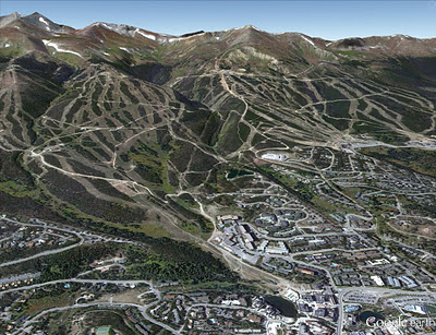
The first example shown below is part of an aerial image acquired this past September of the ski slopes in Breckenridge, Colorado. The slopes have already accumulated several inches of snow over the past few weeks and although it’s still very early in the ski season, a third of all ski lifts are now open! If you can’t make it to the mountains quite yet, be sure to experience the next best thing with Street View imagery from some of the most popular ski destinations.

Perspective view of ski slopes in Breckenridge, Colorado

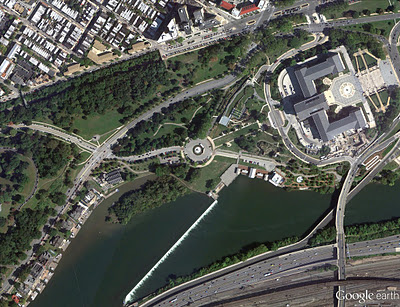
Philadelphia, Pennsylvania is full of iconic landmarks from American history. The aerial image shown below, which was acquired this past October, shows some of the most well known buildings along the east bank of the Schuylkill River. At the bottom left of the image are the fifteen structures comprising Boathouse Row, and the upper right shows the Fairmount Water Works and the Philadelphia Museum of Art. In the far right corner of the image are the stone steps made famous in the Rocky movies.

Boathouse Row, Fairmount Water Works and the Philadelphia Museum of Art, Philadelphia, Pennsylvania

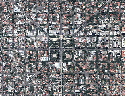
“X” marks the spot in the satellite image below of part of Miramar, Argentina. Of course, the feature is comprised of roads that lead to the town’s central sculpture, Monumento al Gral Alvarado, and the four parks comprising the central plaza.

Miramar, Argentina

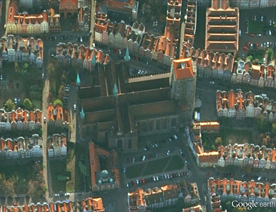
As we close in on the Christmas season, it seems appropriate to feature several well known churches that have been updated with new imagery. The first example, shown below, is aerial imagery of the Basilica of the Assumption of the Blessed Virgin Mary, in Gdańsk, Poland. The structure is considered one of the largest Brick Gothic buildings ever constructed, and has sufficient space to hold 25,000 people!

Basilica of the Assumption of the Blessed Virgin Mary, Gdańsk, Poland

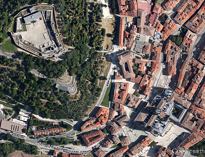
This next example shows updated aerial imagery of Burgos, Spain. In the upper left, is the Burgos Castle, overlooking the Burgos Cathedral in the lower right. This cathedral is famous for its vast size and unique French Gothic architecture.

Burgos, Spain

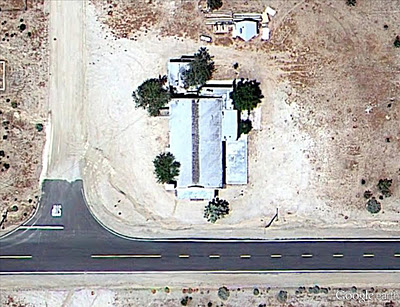
Finally, below is an updated image of the Calvary Baptist Church of Hi Vista, California, perhaps one of the more notable churches of late. This church was of course used famously in the Kill Bill Vol. I movie as the site of near demise for the heroine, “The Bride.”

Calvary Baptist Church, Hi Vista, California

If you’d like to receive an email notification when the Google Earth and Maps Imagery team updates your favorite site(s), we’ve got just the tool: The Follow Your World application!

These are only a few examples of the types of features that can be seen and discovered in our latest batch of published imagery. Happy exploring!

High resolution aerial updates:
USA: Alamosa, CO; Albany, NY; Altoona, PA; Atlanta, GA; Bartlesville, OK; Bishop, CA; Boise City, OK; Clarksville, TN; Clayton, NM; Edwards, CA; Erie, PA; Georgetown, SC; Great Bend, KS; Guymon, OK; Hot Springs, AR; Lamar, CO; Lawton, OK; Llano, TX; McAlester, OK; Merced, CA; Oklahoma City, OK; Palmdale, CA; Philadelphia, PA; Redding, CA; Roseburg, OR; Scranton, PA; Springfield, MO; Texarkana, TX; Twin Falls, ID; Vail, CO

Poland: Bielsko-Biala, Lubaczowski, Malborski, Mazowieckie, Mielecki, Wolowski, Wolczyn,

Spain: Burgos

Switzerland: Horgen

Countries/regions receiving high resolution satellite updates:
Algeria, Argentina, Australia, Austria, Bangladesh, Belarus, Benin, Bhutan, Bolivia, Botswana, Brazil, Bulgaria, Burkina Faso, Burundi, Cameroon, Canada, Cape Verde, Central African Republic, Chad, Chile, China, Colombia, Comoros, Costa Rica, Croatia, Cuba, Cyprus, Czech Republic, Côte d’Ivoire, Democratic Republic of the Congo, Djibouti, Dominican Republic, Ecuador, Egypt, Eritrea, Ethiopia, Finland, France, French Polynesia, Germany, Ghana, Greece, Greenland, Guatemala, Guinea, Haiti, Honduras, Hungary, India, Indonesia, Iran, Ireland, Italy, Japan, Jordan, Kazakhstan, Kenya, Kuwait, Lesotho, Libya, Madagascar, Malawi, Marshall Islands, Mexico, Mongolia, Morocco, Mozambique, Myanmar, Namibia, Nepal, New Zealand, Niger, Nigeria, North Korea, Oman, Pakistan, Papua New Guinea, Paraguay, Peru, Philippines, Poland, Portugal, Qatar, Republic of Korea, Romania, Russia, Rwanda, Saudi Arabia, Senegal, Serbia, Sierra Leone, Slovakia, Somalia, South Africa, Spain, Sri Lanka, Sudan, Svalbard, Swaziland, Sweden, Switzerland, Syria, Tajikistan, Tanzania, Thailand, Togo, Tunisia, Turkey, Uganda, Ukraine, United Arab Emirates, United Kingdom, United States, Uruguay, Uzbekistan, Venezuela, Vietnam, West Bank, Yemen, Zambia, Zimbabwe

These updates are now available in both Google Maps and Google Earth. For a complete picture of where we updated imagery, download this KML for viewing in Google Earth.
The New Bing Maps Features


Coming back after the holiday season with a lot of energy, the Bing Maps team kicked off 2012 with releases of a new routing engine and the WPF control. Today–only 2 weeks later–we are now announcing several new features in the Bing Spatial Data Services and the Bing Maps Account Center. New features include a data source for traffic incidents, the ability to find points of interest (POI) along a route, wildcard-searches in your POI, incremental updates of POI data sources, improved reporting and more. Happy New Year! Are you feeling the love? Smile

The Bing Spatial Data Services provide a REST interface that allows you to geocode or reverse-geocode your own POI data sources in batch-mode, manage these data sources and query your own or some public POI data sources that Bing Maps provides in a spatial context.

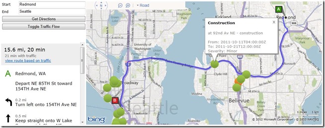
Finding Traffic Incidents Along a Route using the new Spatial Data Services Query

In this release, we added the following features:

  1. Incremental Upload – Your own data sources now support incremental updates by setting the parameter ‘loadOperation’ in the Data Source Management API to ‘incremental’. So, once you’ve uploaded a data source of X number of locations into the Spatial Data Service, if you just want to add a few records you can just send those few records. We’ll handle the add and update functions for you!
  2. Wildcard Searches – New Query Options support wildcard searches through filter criteria. Let’s say you want to query your data source to find the nearest locations around a point AND you want to filter the results based on the beginning or end of a keyword. For example, let’s say you have a “Store Manager” field in your data source. You can look for said manager by last name, “%Smith” or first name “John%” so you get all the Smiths or Johns within a region.
  3. Traffic Incidents – Traffic Incidents for North America are now available as a public POI data source and can be accessed through the Query API. Now the traffic incidents you see on Bing Maps are available to you in your applications via a spatial query.
  4. Find Near Route – The Bing Spatial Data Service supports now an additional spatialFilter which allows you to search for POI along a route. This is a game changer. Let’s say you’re a coffee company and you want to empower your users to have the ability find all your locations along their drive from, say Seattle to San Francisco…now you can! The Find Near Route Feature allows you to spatially query the points you’ve uploaded into SDS within a 1 mile buffer of your route.

http:// spatial.virtualearth.net /REST/v1/data/
439698230d90496596083f3fe7aafeb2/
TrafficIncidents/
TrafficIncident
?key=[YOUR_BING_MAPS_KEY]
&$format=json
&jsonp=callbackFindTrafficIncidentsNearRoute
&spatialFilter=nearRoute(‘47.678558349609375,-122.13098907470703’,
‘47.60356140136719,-122.32943725585937’)

You will find a complete sample using the Bing Maps AJAX Control version 7 for visualization, the DirectionsManager class for driving directions, the TrafficLayer class for traffic-flow information and the Bing Spatial Data Services for traffic-incident information along a route here. Alternate versions of the SDK are available in PDF and .chm format, as well.

Note: Neither the Wildcard-search nor the spatial-filter ‘nearRoute’ are supported with the public data sources NAVTEQNA and NAVTEQEU.

The Bing Maps Account Center is the portal through which you can find information for development with Bing Maps, and also manage your account. It contains links to interactive and traditional SDKs, a facility to generate Bing Maps Keys, a web user interface to manage your own POI data sources and a reporting service through which you can retrieve statistics about your Bing Maps usage.

In this latest release we added the following features.

  1. Additional data validation has been introduced for the upload of your own POI data sources.
  2. Before it was already possible to add and edit records in a data source that you uploaded through the portal. You can now also download and delete data sources.M32small
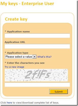
  3. Image capturing adds now additional security during the generation of Bing Maps Keys.M33small
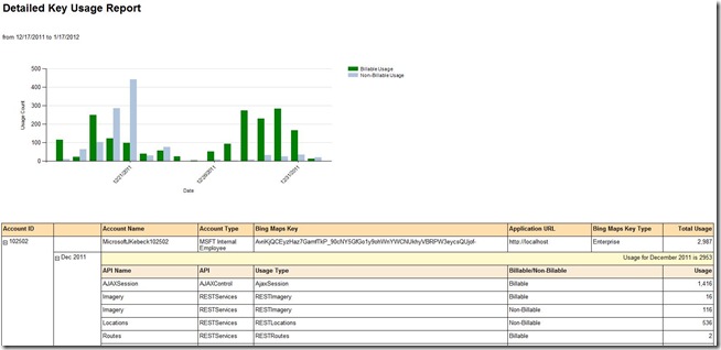
  4. Additional reports have been added to provide more details on the use of specific Bing Maps Keys.M34small

We certainly hope you’re feeling special (and spatial!). We’re investing quite a bit of energy into Bing Maps and hope to see some killer apps.

Bing Maps Token Service – Upgrade to Keys Today!

For our current Bing Maps Platform customers using the Bing Maps Token Service, we want to remind you that this service will be retired on March 30, 2012. Please be sure to upgrade any of your applications that are using the Bing Maps Token Service to Bing Maps Keys before this date to ensure that your access to the Bing Maps Platform is not interrupted.

What Bing Maps Platform API’s does this upgrade apply to?

This upgrade only applies to the following Bing Maps Platform API’s:

What are the benefits of using Bing Maps Keys instead of the Bing Maps Token Service?

  • Improved performance in accessing the Bing Maps Platform (i.e. the elimination of the requirement to call the Token Service prior to calling the Bing Maps API’s).
  • Unlike Bing Maps Tokens, Bing Maps Keys do not expire.
  • Enhanced management and reporting of your Bing Maps Platform usage (i.e. you can assign a unique Bing Maps Key to each of your applications to separately track the Bing Maps usage for each of your applications).

How can you tell if you are currently using the Bing Maps Token Service?

How do you get started with upgrading from the Bing Maps Token Service to Bing Maps Keys?

To get started, please follow the MSDN article, Migrating from Tokens to Keys, which explains how to obtain a Bing Maps Key, and provides guidance on upgrading your applications to Bing Maps Keys for applications using the Bing Maps AJAX Control, the Bing Maps Silverlight Control, or Bing Maps SOAP services.