3ds Max 2011 One Project from Start to Finish

3ds Max is a uniquely powerful modelling program, yet one that can catch out both new comers and even advanced users out with its intricacies and workflows. Many tutorial style books are fundamentally flawed by assuming the reader is already familiar with various aspects of the software. Indeed, we remember well a book that stated ‘now complete this easy step’ only to leave us both frustrated and annoyed as we failed to grasp the instructions.

What therefore is needed is a book that illustrates the process of creating a 3D visualization project step by step – and we are pleased to say there finally is a book worthy of its title ‘3ds Max 2011, One Project from Start to Finish’.

The movie below details the model produced over 9 chapters and the good news is we have three copies to give away, full details at the end of the post:

The book has been designed to be useful for readers at all skill levels. The material is presented in a way that will engage advanced users while still being explicatory enough for beginners – which is great to see.

Covering 2D-3D Modelling, Terrain Creation, Tree Creation, Water Elements, Animation, Lighting, Rending, Particles Systems and more the book provides a fully structured guide.

If your only going to buy one 3D modelling book this year then 3ds Max 2011 – One Project from Start to Finish is simply the best option.

The publishers 3DATS have kindly provided us with 3 copies to give away to readers – simply retweet this post and we will pick 3 winners at random from the Twitter feed. Competition ends 28th February, so you have a week to enter.

The retweet button is at the top of the post, good luck, books will be shipped Tuesday 29th, each valued at $99.95.

De-coding the “Decode Jay-Z with Bing” Campaign

Last month, Bing concluded the Decode with Jay-Z campaign – a campaign which ambitiously brought every page of Jay-Z’s new book, Decode, into both the real world – on New Orleans rooftops, Miami swimming pools, Manhattan billboards – and into an online contest built on the Bing Maps platform. In order to provide an immersive game experience which would hook the user into a scavenger hunt for over 200 pages, our development partner – Vertigo – leveraged the Bing Maps API and created new ways to customize the Bing Maps experience for the Jay-Z brand.

Decode Homepage

Bing Maps was a central grounding element in the Decoded marketing campaign. Visitors answered questions and then navigated through both aerial and StreetSide views to solve clues and discover pages. Decoded provided contextual geographical and subject-matter content, and Bing Maps provided the surface area in which to experience the game. Users learned to navigate Bing Maps views as they competed to win prizes.

To bring the creative vision of the campaign to life, Vertigo’s development team made a number of modifications to the Bing Maps API.

· An important interaction for Decoded users included navigating through neighborhoods and locating pushpin-like objects. For displaying pushpin-like objects in StreetSide view, Vertigo extended the API to support this feature. We created a custom container for the page which appeared at a specific geo-coordinate: a street corner, the wall of a building, a swimming pool at a luxury hotel, etc.

· In order to create a custom container, Vertigo placed a UI element on top of Bing Maps in StreetSide view. By manipulating the size, scale and transforms of the custom Silverlight element, the game player would perceive it to be part of Bing Maps.

· Vertigo also wrote a helper that detected when the player attempted to move outside of the areas supported by StreetSide view. While explicit detection is not possible, the software detected when the visitor tried to move and the new geo-coordinate location was the same as the old location. In this case, we could inform the player through subtle UI interactions and smooth out a potentially difficult game play experience.

· Vertigo developed a tool which allowed the content administrator to enable or disable StreetSide view on a given page when StreetSide view was not available for the given geo-coordinate. When the game play for a given page was not supported in StreetSide view, the player would need to zoom down to a specific level, one or two positions from the maximum zoom level, in order to find the page in aerial view. Obviously, zooming all the way out to find the page would make the game play experience too easy.

· Vertigo’s interaction designer created custom controls which then bound to specific Map functions that allowed the user to pan and zoom.

Custom modifications allowed for more accurate neighborhood boundaries in a number of ways:

1) Vertigo paired the Decoded game site a separate administration website built with ASP.Net MVC. This administrative website managed the database that controlled the game. In order to define the neighborhood boundary which contained the book page, the administrator built a complex polygon by selecting points on the map. Some polygons included over 1000 geo-coordinates.

2) Vertigo used the Bing Maps API to convert each point into a latitude and longitude. Once the administrator selected three points, a polygon appeared on the map. Polygons were drawn on the Silverlight Bing Maps control with standard Bing Maps API calls using a white border for highlighting. The administrator could then alter the shape of the polygon by adding additional points. Once finished, the polygon geo-coordinates were stored in the database.

3) When the visitor navigated to a given page, the Silverlight application retrieved geo-coordinates for the neighborhood boundary and drew them on the Bing Maps control.


Decode Neighborhood

Decode Streetside

In order to draw the book page and have it appear to be part of the StreetSide map view, three values needed to be calculated: the x and y coordinates to position the element, and a scaling factor to make the element smaller when it was farther away.

The following calculations were used to derive these values:

Calculate Y Coordinate

UIElementDistance = DistanceInMeters(UIElementLocation, CurrentLocation)

altitudeDif = CurrentAltitude –

Flip Bits not Burgers, the Student Guide


The Google Summer of Code Mentor Manual, published before the 2009 Mentor Summit, was an effort to help mentors choose the best students and get them involved in the open source community. The Mentor Manual had some extremely useful tips on how organizations can make the best use of the program, so in 2010 the authors printed a new edition that has tips for organization administrators as well!

When you have a manual for the mentors and org admins, it’s only fair and logical to have one for the students as well. After all, they’re the ones who need the most help preparing for and working on Google Summer of Code! So the authors of the Mentor Manual decided to write a Student Manual in the days before the 2010 Mentor Summit, and they realized it would be a good idea to get input from students. This is where I enter the scene–I was a Google Summer of Code student for the Systers organization in 2009, and a mentor for Systers in 2010. Jennifer Redman, my mentor in 2009 and co-author of the original Mentor Manual, suggested that I participate in the book sprint for the Student Manual so I could share my first-hand experience as a student.

We wanted the Student Manual to be the one stop shop for all the questions that students might have about Google Summer of Code. The manual has great insights for students before, during and after the program. These include:

• How to decide whether or not to apply for Google Summer of Code
• Getting code reviews and handling feedback
Interacting with mentors
Staying involved after the program ends

The book also has some very useful advice on making first contact with the mentoring organization, appreciating the open source culture, and most importantly, writing good project proposals.

Who can give better advice on writing good proposals for Google Summer of Code than the people who would actually evaluate them? I think the suggestions on how to write a good proposal, straight from the mentors, is something that makes the book extremely useful for the students. The book also has suggestions on selecting the projects that you should consider applying for, how to manage your time better, and how to get the most from your mentor and Google Summer of Code–there’s even a section on what to do if you’re not selected. This goes extremely well with the spirit of Google Summer of Code where one of the goals is to get students involved in open source projects irrespective of them being Google Summer of Code students or not. I guess I can go on and on about the book and the chapters, so a better option might be to check out the book and see for yourself: http://www.booki.cc/gsocstudentguide/

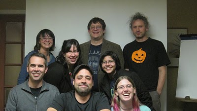
Google Summer of Code Student Manual Authors, photo by Selena Deckelmann

We have made a sincere effort to include as much useful advice and as many helpful suggestions in the book as possible, and in true open source style, there is an editable version available, so if you feel that something is missing in the manual, you can make a contribution to it!