China targets illegal maps

Yes, it is not a mistake. Maps can be “illegal”. That is, only in countries that have in place a licensing regime – such as China. The aim is to remove from the web maps that have “political mistakes” (I presume it refers mainly to representation of borders and “territories”) and those that disclose State secrets (I remember this rule from the old communist country of my origin, where city maps had big holes where the industrial zones were located). Well, that’s one way to achieve consistency in mapping data across the whole country, just hope no one will have similar ideas in Australia!

What’s really interesting, are statistics quoted by the Chinese State Bureau of Surveying and Mapping: it “…uncovered 1,058 cases of illegal mapping services, including more than 30 relating to foreign organisations and military”, “…3,686 websites out of 41,670 web mapping service websites were found to contain political mistakes, and more than 200 websites were closed”. Mapping must be quite popular there, but that’s China. I wonder what would be the numbers for Australia (total websites of course, not closures!).

On a related topic, Chinese government is not the only one censoring online content. Google created this interesting map that shows world wide statistics about “Government requests directed to Google and YouTube” to remove content from services, or provide information about users of services and products.
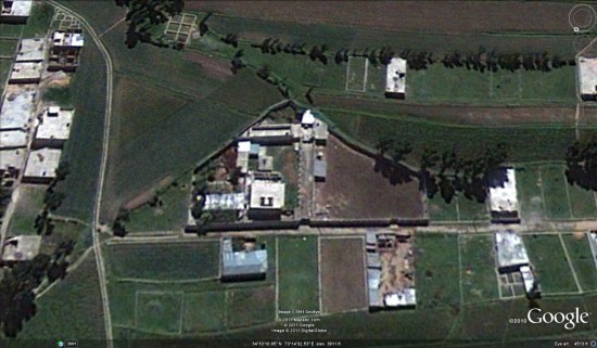
New Google Earth imagery coming this week


In a bit of a surprise move, rather than allowing us to discover new imagery in Google Earth, Google has pre-announced an imagery update that is due out later this week.

[UPDATE: The imagery is now live in Google Earth. See the bottom of this post for a list of updated areas.]

Part of the update will include some high-quality imagery from Abbottabad, Pakistan, which was captured in May, 2010. They’re offering a preview of that imagery via this KML file.


new-imagery.jpg 

In addition, the very new GeoEye imagery of Abbottabad that we mentioned yesterday will be available in the historical imagery feature of Google Earth soon. Remember, historical imagery is sometimes newer than the base imagery.

It sounds like it’s quite a major update, and we’ll be sure to let you know when it goes live. Here is the full list of areas that will be getting fresh imagery:

High Resolution Aerial Updates:
USA: Brookshire, TX; Brownsville, TX; Dallas, TX; Ft Stockton, TX; Hebbronville, TX; Houston, TX; Laredo, TX; McAllen, TX; Milwaukee, WI; Padre Island, TX; Wharton, TX; Zapata, TX;
Australia: Central Coast, New Castle, and Salamander Bay
Norway: Buskerud, Fredrikstad, and Oslo

Countries/Regions receiving High Resolution Satellite Updates:
Algeria, Angola, Antarctica, Antigua and Barbuda, Argentina, Australia, Austria, Bangladesh, Belarus, Benin, Bolivia, Brazil, Burundi, Cameroon, Canada, Central African Republic, Chad, Chile, China, Colombia, Costa Rica, Croatia, Czech Republic, Democratic People’s Republic of Korea, Democratic Republic of the Congo, Denmark, Djibouti, Dominican Republic, Egypt, Eritrea, Estonia, Ethiopia, Finland, France, Georgia, Germany, Greece, Greenland, Grenada, Guadeloupe, Guinea, Haiti, Honduras, Hungary, India, Indonesia, Iran, Ireland, Israel, Italy, Japan, Jordan, Kenya, Kuwait, Latvia, Lebanon, Lesotho, Lithuania, Madagascar, Malawi, Mali, Mexico, Mongolia, Morocco, Mozambique, Myanmar, Namibia, Nepal, Netherlands, New Zealand, Niger, Nigeria, Norway, Oman, Pakistan, Paraguay, Peru, Philippines, Poland, Portugal, Republic of Korea, Romania, Russia, Saudi Arabia, Senegal, Serbia, Seychelles, Sierra Leone, Slovakia, Somalia, South Africa, Spain, Sri Lanka, Svalbard, Swaziland, Sweden, Switzerland, Syria, Taiwan, Tanzania, Thailand, The Gambia, Tunisia, Turkey, Uganda, Ukraine, United Arab Emirates, United Kingdom, United States, Uruguay, Venezuela, West Bank, Western Sahara, Yemen, Zambia, Zimbabwe

Google Earth: Imagery Update – April 25th

The Google Earth and Google Maps Imagery Team has just published it’s latest batch of satellite and aerial imagery and as always, there’s all kinds of fascinating sites and features to see.

This release will be our last for April and this month, in particular is always associated in the northern hemisphere with spring and new beginnings. We can trace the meaning of the word April to the latin word aperire, “to open,” and what better way to describe “open” than the start of another Major League Baseball season! Below you can see in high-resolution glory, the 2010 World Champion San Francisco Giants warming up at their Scottsdale, Arizona spring training park for opening day and defense of their title. In this image, they were hosting the Milwaukee Brewers. As the Giants’ home field is only an hour away from Google’s HQ in Mountain View, they are often the talk of choice in our offices!


Scottsdale Stadium, Scottsdale, Arizona

Below is another example of new beginnings. In this high-res aerial example, we can see Plymouth Rock (lower left), landing site of English Separatists and Anglicans looking for a new life, and the Mayflower 2 (upper right), a replica of their ship the Mayflower, both of which are located in Plymouth, Massachusetts.


Plymouth Rock, Plymouth, Massachusetts

Finally, here’s an aerial image of the Sendai Airport in Sendai, Japan as they’re preparing to re-open. To see how the clean-up and rebuilding has progressed at the airport and adjoining neighborhoods, use Google Earth’s Historical Imagery slider to see earlier post-quake imagery of the area. It’s impressive to see.

Sendai Airport, Sendai, Japan

Do you have a place you love that you’d want to receive notification from us when the Earth and Maps Imagery team updates your beloved site? We’ve got just the tool: the Follow Your World application!

As always, these are but a few examples of the types of features that can be seen and discovered in our latest batch of published imagery. Happy exploring!

High Resolution Aerial Updates:
USA: Phoenix, Tuscon, Albuquerque, Amarillo, Wichita, Austin, Cape Cod
Japan: Sendai

Countries/Regions receiving High Resolution Satellite Updates:
Antarctica, Armenia, Australia, Azerbaijan, Brazil, Burkina Faso, Canada, Chad, China, Croatia, Egypt, England, France, Georgia, Germany, Haiti, India, Israel, Italy, Japan, Kazakhstan, Madagascar, Mexico, Morocco, New Zealand, Nigeria, North Korea, Norway, Pakistan, Philippines, Poland, Romania, Russia, Saudi Arabia, Scotland, Senegal, Slovakia, Spain, Sweden, Turkey, United Arab Emirates, United States, Uruguay, Western Sahara, Yemen, Zambia

These updates are now available in both Google Maps and Google Earth. To get a complete picture of where we updated imagery, download this KML for viewing in Google Earth.