Google Earth and London in 3D

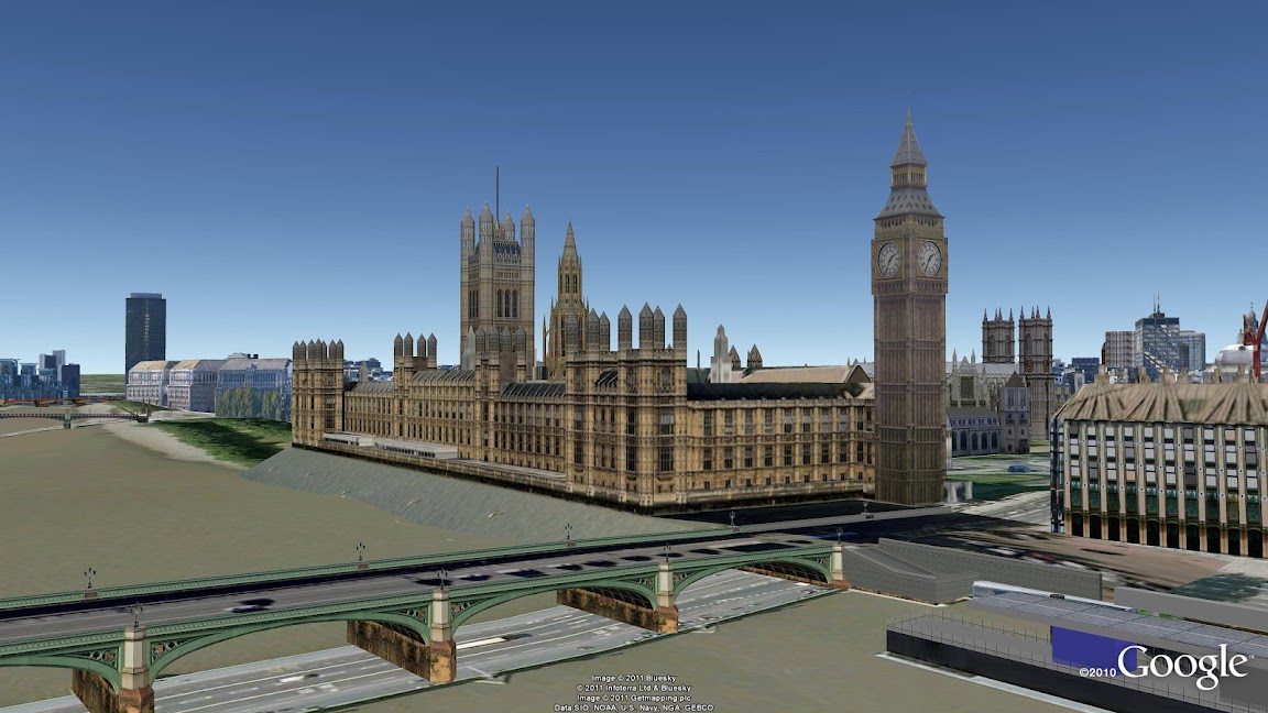
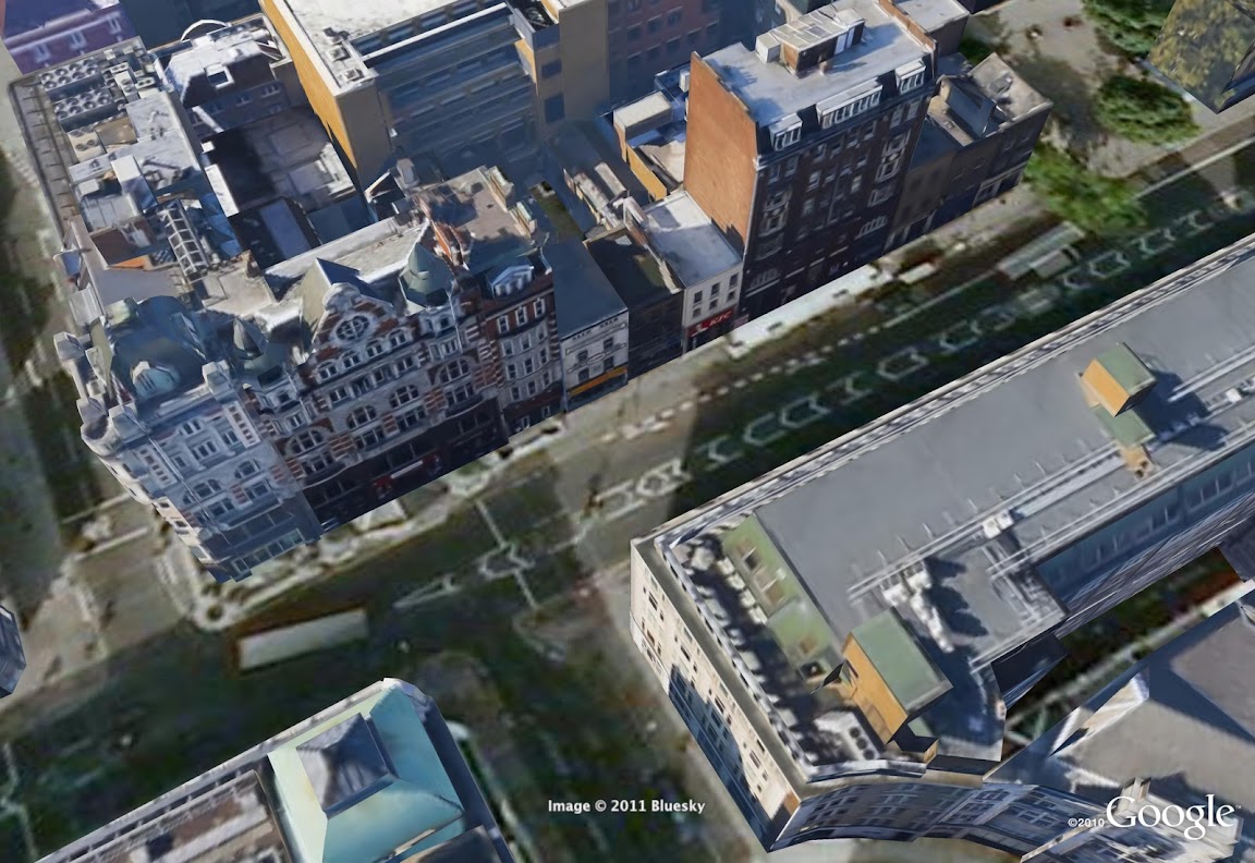
On April 29, the eyes of the world will focus on London for the royal wedding of Prince William and Catherine Middleton, and the U.K. will deliver a royal celebration that will capture the imagination of a global audience. We’re doing our part too: following last week’s announcement of new aerial imagery for London, we’re expanding our 3D imagery of central London’s buildings and trees in Google Earth—including the entire royal procession route.

With this new 3D data covering the royal procession route, you can indulge yourself in a “royals’-eye” view to see the same sights that William and Catherine will see. Upon departing Westminster Abbey, you’ll pass the Houses of Parliament and Big Ben, the famous ministries on Whitehall and the Prime Minister’s residence at 10 Downing Street. Traverse Horse Guards Parade, and from there, you can travel down The Mall—with 3D trees lining the route—and see Buckingham Palace standing proudly at the finish.

This new 3D imagery isn’t limited to the royal parade route. Thousands of buildings are available, so people from around the globe can digitally experience the beauty of London. You can view buildings such as the British Museum, a treasure trove of historical artifacts, Goodge Street tube station, where General Eisenhower commanded allied forces in WWII, and Shaftesbury Avenue, the historical theatre district of London.

What’s more, we’ve also turned St James’ Park, Green Park and Hyde Park into a 3D lush green carpet, thanks to the help of our friends at the Royal Parks. We’ve modeled five different species of trees, and virtually planted more than 12,000 individual trees (available in Google Earth 6).

To see all the landmarks and greenery in Google Earth, check the 3D buildings box in the left-hand panel under “Layers,” type “London” in the search bar on the top left and use the navigation controls in the upper right to zoom in, spin around and tilt the view. Or you can go to Earth View on Google Maps in your browser.

Since moving to London from Leek, in Staffordshire, I’ve grown to appreciate all the royal and historic landmarks in the capital. So whether you’re standing near me and millions of my fellow Britons on the Mall on April 29 to catch a glimpse of the happy couple, or enjoying the spectacle from home, I hope this new 3D data for London brings you closer to this wonderful city.

A preview of the sunrise on April 29

Geography as art

While maps are often considered guides to get from here to there, on the Google Maps and Earth team, we’re constantly thinking of innovative ways to express geographic information. From helping you see the world from a street-level perspective with Street View, to enabling you to dive into the Ocean layer in Google Earth, new geographic visualizations are top of mind for the team. With that mapping mindset, Group Product Manager Lior Ron was struck by the abstract landscape paintings he saw at the Sausalito art festival.

Ben Joyce’s painting of San Francisco caught his attention: “The color scheme, brush strokes, and the open frame prompted my imagination freely to think about San Francisco and what I love about this city. What a wonderful way of visualizing spaces!”
San Francisco at Night by Ben Joyce
Ben describes his work as Abstract Topophilia: “The affective bond between people and place. The Love of Place,” and explains how cities like San Francisco inspire his artwork: “There is great beauty and intrigue in the layout of a city – from your everyday drive to work, to the historical creation of the streets, to your personal relationship with the town.”
When Lior shared Ben’s work with some teammates, we too were fascinated by the bold color schemes and dramatic visualizations of geographic information, and were thrilled to learn that Ben has consulted Google Earth to create his city artwork. To share these creative visualizations with the team, we invited Ben to show some of his artwork in our team building, with depictions of cities ranging from Florence to Moscow.
Moscow by Ben Joyce
When we first hung up the paintings, we omitted location descriptions and opened a contest for the team: who could identify all of the paintings first? Google Earth Community Program Manager Robin Ziegler identified all of the locations about 30 hours after we started the challenge, and even plotted all of the paintings in Google Earth. Here you can see how Robin aligned Ben’s painting of Miami with the corresponding imagery in Google Earth.


Ben’s artwork will stay in our team’s building for the next three months, and will continue to remind us of the creative potential of geographic information.
Posted by Emily Henderson, Administrative Assistant, Google Maps & Earth

Discover Yours: Local recommendations powered by you and your friends

There’s something so exciting about discovering new places. Nothing beats finding a great new place I’ve never been—whether it’s a new bakery with a special dessert, a hole-in-the-wall Mediterranean place I didn’t notice before or a local art gallery where I can let my imagination roam free.

The challenge with finding those great places is that each of us has different tastes. I want to find places I like and I want to find them quickly. So when I’m overwhelmed with possibilities, I turn to sources I can trust. For example, if I’m in a new city, I might chat with the concierge at my hotel and explain to him the kinds of places I like so he can give me personalized recommendations, or I’ll ask my friends for local recommendations because I value their opinions and we have similar tastes. But finding trusted advice is hard; wouldn’t it be great if there was a way for me to get these recommendations all the time, everywhere I go?

We are trying to do exactly that, and today we’re excited to share the first step: an early release of Hotpot – a local recommendation engine powered by you and your friends. With Hotpot, we’re making local search results for places on Google more personal, relevant and trustworthy. There are three main ingredients in the Hotpot recipe:

  • Google Places – These are the 50 million places around the world for which we have rich details.
  • The places you like – When you rate places you like, we’ll tell you about other related places you’ll love. I love my favorite neighborhood restaurant in Noe Valley, Firefly, so when I rate it 5 stars, Hotpot will try to recommend other places for me in the city with simple, homey food such as Home restaurant.
  • The places your friends like – Share your ratings with your friends and see the places they’ve recommended. I’m planning a trip to Barcelona for the holidays and my friend Bernardo is a local. With Hotpot, I can see his recommendations when planning my trip on Google Maps, or when I’m in Spain using Google Maps or Places for Android.


Combining these three ingredients makes the hard task of choosing where to go easy; all you need is to rate places and add your friends. To do that we created the Hotpot rating app: quickly rate all the places you’ve been to and choose exactly which friends you want to invite to Hotpot. Then, when you’re visiting places, you can continue rating on the go from Mobile maps on Android.

Rate from the Hotpot rating app
Rate from Mobile maps on Android

Your recommendations are with you whenever you need them. In search results, you can see recommended places by using the new Place Search and clicking on the “Places” filter. You can also see recommendations when searching on Google Maps, Google Maps for Android or when checking the Place pages for a specific business.

Recommendations on Place Search

Recommendations on a Place page

Recommendations on Google Maps for Android

You can set a Places nickname (here’s how) when you start using Hotpot, so you control how you post your ratings. That way, only your friends will be able to see your real name.

Happy hotpotting!