Last year, Laura Hillenbrand released a book titled “Unbroken: A World War II Story of Survival, Resilience, and Redemption“, based on the life of Louis Zamperini (details on Amazon). The book has been very popular, quickly becoming a best-seller and recently being picked up by Universal Studios to be turned into a movie.
The life of Zamperini is amazing, and the book is excellent. Zamperini, a world-class runner that competed in the Berlin Olympics in 1936, is drafted into World War II. He fights a number of missions before his plane goes down and he’s trapped in a raft at sea. After 46 days at sea, he floats into the Japanese-controlled Marshall Islands, and he’s placed in various POW camps for the next few years.
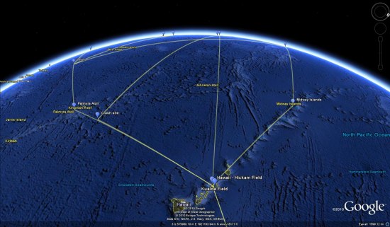
In reading the book about his journey, I realized that it would pretty cool to track down his various missions and POW camps in Google Earth. I was right! However, I was unable to find a decent timeline of his life, so I spent a few hours researching it and created one myself. After that, I did more research to find all of those locations in Google Earth and ended up with a pretty cool file.
The file includes locations from his early days (homes, school), the various places he went for military training, the Pacific missions he completed, the POW camps he was placed in, and the various stops on his journey home. You can download the KMZ file here to try it for yourself.
I had hoped that historical imagery might come into play with this, but the old imagery in the Pacific and Japan doesn’t go back nearly far enough (as opposed to Europe, where many locations have historical imagery dating back to the mid-1940’s). However, one good example was Hamilton Field, where he stopped over on his way to Hawaii. The present-day imagery no longer shows a runway, but if you switch to the 1993 imagery you can clearly see the runway still there.
All of that being said, I’m sure the file isn’t perfect. If you make any corrections to it, please email me the updated version (mickey@gearthblog.com) and I’ll update this post.
Today we’re introducing the latest version of Google Earth, our interactive digital atlas. Now you can explore your childhood home, visit distant lands or scope out your next vacation spot with even more realistic tools.
In Google Earth 6, we’re taking realism in the virtual globe to the next level with two new features: a truly integrated Street View experience and 3D trees. We’ve also made it even easier to browse historical imagery. Over the next several days, we’ll be digging deeper into these great new features, but here’s an overview to whet your appetite.
Integrated Street View When Google Earth was first introduced, people were wowed by the ability to virtually fly from outer space right down to the roof of their house. While flying over rooftops gives you a super-human view of our world, the ground level is where we experience our daily lives. We took our first baby steps toward bringing the Google Earth experience to street level with our implementation of Street View in Google Earth in 2008, which enabled flying into Street View panoramas. In Google Earth 6, the Street View experience is now fully integrated, so you can journey from outer space right to your doorstep in one seamless flight.
Now, you’ll notice that Pegman is docked right alongside the navigation controls—an ever-present travel companion ready whenever you want to get your feet on the street and take a virtual walk around. Just pick up Pegman and drop him wherever you see a highlighted blue road to fly right down to the ground. Once there, you can use the navigation controls or your mouse to look around. And unlike our earlier Street View layer, you can now move seamlessly from one location to another as if you’re walking down the street by using the scroll-wheel on your mouse or the arrow keys on your keyboard. If you want to visit somewhere farther away, simply click the “exit” button and you’ll immediately return to an aerial view where you can easily fly to your next destination.
Drag and drop Pegman to enter Street View. The blue lines indicate where Street View imagery is available.
3D trees I think we can all agree that our planet without trees would be a pretty desolate place. Besides the ever-important task of providing us with the oxygen we breathe, trees are an integral part of the landscape around us. In Google Earth, while we and our users have been busy populating the globe with many thousands of 3D building models, trees have been rather hard to come by. All that is changing with Google Earth 6, which includes beautifully detailed, 3D models for dozens of species of trees, from the Japanese Maple to the East African Cordia to my personal favorite, the cacao tree. While we’ve just gotten started planting trees in Google Earth, we already have more than 80 million trees in places such as Athens, Berlin, Chicago, New York City, San Francisco and Tokyo. Through our Google Earth Outreach program, we’ve also been working with organizations including the Green Belt Movement in Africa, the Amazon Conservation Team in Brazil and CONABIO in Mexico to model our planet’s threatened forests.
To enjoy these leafy additions to Google Earth, make sure you turn on the 3D buildings layer on the left side panel. As a starting point, try a search for “Palace of Fine Arts San Francisco.” Once you arrive at your destination, click the zoom slider. You’ll then be taken down to the ground where you can use our new ground-level navigation to walk among the trees.
3D trees in San Francisco, California
Easy-to-use historical imagery One of the features people told us they liked best in Google Earth 5 was the availability of historical imagery, which enables you to visually go back in time to see such things as Warsaw in 1935, London in 1945, and Port-au-Prince Haiti before and after the devastating earthquake of January 2010. But it wasn’t always obvious when historical imagery was available for a particular place, making this feature one of Google Earth’s lesser-known gems.
So with this new version, we’ve made it very easy to discover historical imagery. When you fly to an area where historical imagery is available, the date of the oldest imagery will appear in the status bar at the bottom of the screen. If you click on this date, you’ll instantly be taken back in time to view imagery from that time period. You can then browse through all the historical imagery available for that location, or simply close the time control and return to the default view.
The site of Google’s Mountain View campus in 1948
To download Google Earth 6, or to see videos of our newest features, visit http://earth.google.com.
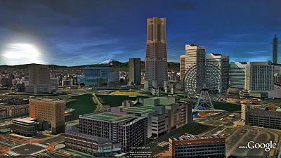
Today, we’re happy to announce that three more Japanese cities are viewable in 3D in Google Earth: Yokohama, Sendai and Saitama.
Sun rising over Yokohama.
You can now tour photo-realistic, 3D buildings in these cities without leaving your house—or climbing aboard a shinkansen.
If you’d like to extend your virtual stay in Japan, you can take a tour of Tokyo, Kobe, Osaka or Kyoto, which are also available in Google Earth’s 3D Buildings layer.
We want to thank the many users who modeled and contributed 3D buildings for these Japanese cities. If you’re interested in creating buildings for your town—or for any town—we have several easy-to-use tools to get you started.
With Google Building Maker, you can create and contribute a building in as little as 10 minutes. In Japan, Building Maker is available for the following cities: Fukuoka, Hiroshima, Kobe, Kyoto, Nagoya, Osaka, Saitama, Sapporo, Sendai, Tokyo and Yokohama. And if you’d like to refine your building bring it into Google SketchUp for fine-tuning.
 to try it for yourself.
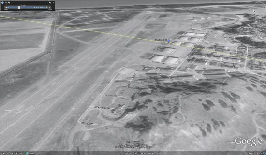


 Sun rising over Yokohama.