Tahina Expedition


Frank Taylor here, the founder and publisher of Google Earth Blog. Many of you who are regular readers of Google Earth Blog know that since November of 2009 my wife and I have been traveling by sailboat on a round-the-world trip we call the Tahina Expedition. Tahina is the name of our boat which we bought in 2008. We sold our house, cars and most of our belongings to have this opportunity to see many of the most remote parts of the Earth that we had only visited in Google Earth before. We have already crossed the Pacific Ocean leaving our home state of North Carolina to the Caribbean sea, to San Blas, the Panama Canal, Galapagos, French Polynesia, the Cook Islands, Niue, Tonga, and New Zealand.

In early May of this year, we left New Zealand and sailed for seven days up to Fiji. Since that time, we have had some amazing experiences in Fiji. We have enjoyed visiting with people in remote villages of eastern Fiji – many who have rarely seen foreigners and have little contact with the modern world. We have had some amazing underwater experiences on some of the liveliest coral we have ever seen. We have had remarkable encounters with marine life such as dolphin, sea turtles, lionfish, shark, sea snakes, eels, manta ray and more. We have also seen some pretty unique locations such as underwater caves, uninhabited islands, white sand beaches, and huge island resorts.


Fiji Tracks in Google Earth 

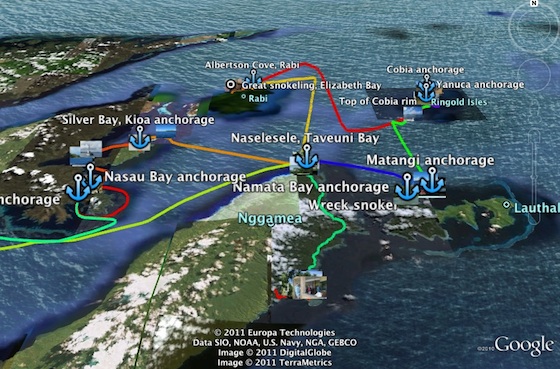
Today we published a Google Earth file of our Fiji experiences . It includes GPS tracks of our routes as we sailed between anchorages. It also has tracks of dinghy trips to various places, hikes, kayaking trips, and even some taxi trips. There are placemarks of our anchorages, dive sites, and other points of interest along the way. And, finally, the file includes links to all the geo-tagged photos from albums we have published to Picasa. You can read more about the file in the post at the Tahina blog.

Natural Earth Free Map – Updated Data

Natural Earth is a free, public domain map dataset available at 1:10, 1:50, and 1:110- million scales and includes new vector and updated raster themes. The goal is to give cartographers and GIS users an off-the-shelf solution for creating small scale world, regional, and country maps.

To celebrate the 1 year-anniversary of the Natural Earth project by introducing a new “quick start kit” (150 mb ZIP) that includes a sampling of Natural Earth vector and raster data and an ArcMap document that compiles the themes into an easy to browse, styled map. The map comes in two flavors and scales: the world (zoom to all) and at a regional scale (zoom in to U.S. states and countries world wide) with cultural and physical data frames to switch between.

You can download individual themes (or the whole set) from naturalearthdata.com, where you’ll find raster imagery of Natural Earth I and II in perfect registration with the vector linework. Both political and physical features are included in Natural Earth data.

Natural Earth solves a problem that many map makers face: finding vector data to make publication-quality small scale maps. At a time when the web is awash in interactive maps and free, downloadable vector data, such as the Digital Chart of the World and VMAP, map makers are forced to spend time sifting through a confusing tangle of poorly attributed data. Many map makers working under tight project deadlines must use manually digitalized bases instead.

natural earth screenshot

Small scale map datasets of the world do exist, but they have their problems. For example, most are crudely generalized—Chile’s fjords are a noisy mess, the Svalbard archipelago is a coalesced blob, and Hawaii has disappeared into the Pacific two million years ahead of schedule. They contain few data layers, usually only a coast and country polygons, which may not be in register.

The lack of good small scale map data is not surprising. Large mapping organizations that release public domain data, such as the U.S. Geological Survey, are not mandated to create small scale map data for a smaller user community that includes map making shops, publishers, Web mappers, academics, and students—in other words, typical cartographers.

Nathaniel Vaughn Kelso, The Washington Post

Tom Patterson, U.S. National Park Service

Originally Posted by ESRI Mapping Center http://blogs.esri.com/Support/blogs/mappingcenter/archive/2011/02/08/natural-earth-the-free-world-base-map.aspx

Journey in Google Earth

Last year, Laura Hillenbrand released a book titled “Unbroken: A World War II Story of Survival, Resilience, and Redemption“, based on the life of Louis Zamperini (details on Amazon). The book has been very popular, quickly becoming a best-seller and recently being picked up by Universal Studios to be turned into a movie.

The life of Zamperini is amazing, and the book is excellent. Zamperini, a world-class runner that competed in the Berlin Olympics in 1936, is drafted into World War II. He fights a number of missions before his plane goes down and he’s trapped in a raft at sea. After 46 days at sea, he floats into the Japanese-controlled Marshall Islands, and he’s placed in various POW camps for the next few years.

In reading the book about his journey, I realized that it would pretty cool to track down his various missions and POW camps in Google Earth. I was right! However, I was unable to find a decent timeline of his life, so I spent a few hours researching it and created one myself. After that, I did more research to find all of those locations in Google Earth and ended up with a pretty cool file.

zamp-hawaii.jpg

The file includes locations from his early days (homes, school), the various places he went for military training, the Pacific missions he completed, the POW camps he was placed in, and the various stops on his journey home. You can download the KMZ file here to try it for yourself.

I had hoped that historical imagery might come into play with this, but the old imagery in the Pacific and Japan doesn’t go back nearly far enough (as opposed to Europe, where many locations have historical imagery dating back to the mid-1940’s). However, one good example was Hamilton Field, where he stopped over on his way to Hawaii. The present-day imagery no longer shows a runway, but if you switch to the 1993 imagery you can clearly see the runway still there.

hamilton-field.jpg

All of that being said, I’m sure the file isn’t perfect. If you make any corrections to it, please email me the updated version (mickey@gearthblog.com) and I’ll update this post.