Google Earth on 48 screens

Back in 2009, Google developed the first Liquid Galaxy, an entirely new way to display Google Earth on eight screens – which creates an immersive experience of virtually flying around the globe. Since then, we’ve built dozens of Liquid Galaxies all over the world and open sourced the code so anyone can build their own.

Late last year, the Paris Center for Architecture and Urbanism: Le Pavillon de l’Arsenal, approached us asking if they could use Google Earth to power a new interactive display highlighting the Paris metropolitan area in 2020 with upcoming buildings in 3D. Naturally, we were excited about the project, especially when they shared that the display would be 40 square meters – posing a fun and unique challenge.

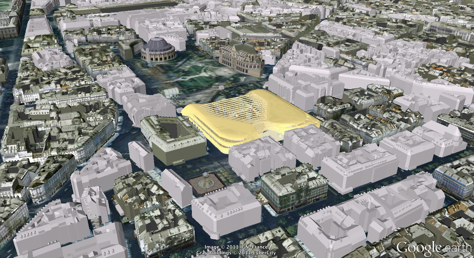
A year later, we are excited to share that the first 48 screen Liquid Galaxy is now on display in Paris. We believe this to be the largest screen showing Google Earth to date!

Photo: Vincent Fillon
What started as a 20% project to support the new Google Cultural Institute resulted in a stunning display of the Earth in almost 100M pixels – powered by 48 instances of Google Earth synchronized and operated through 4 multi-touch screens with pinch and zoom functionality. The view is even sharper due to a refresh of the entire Paris area with higher resolution imagery.

As a Parisian, it’s amazing to be able to see what the city will look like in the future. If you can’t make it to France in the near future, you can preview it at home by downloading this KML file and opening it in Google Earth.

The Canopy and Transport Hub: Patrick Berger and Jacques Anziutti architects
This project was a close collaboration between Google and Le Pavillon de l’Arsenal, as well as technology JCDecaux, End Point and design partners ultranoir.

Over the next few months we’ll be fully open sourcing this work on Liquid Galaxy, as well as the graphical interface. Keep an eye out on our source code page for updates.

Google Earth Imagery: The end of October

What do Elvis’ Graceland and Iran’s Marmar Palace have in common? Both estates have been updated with new imagery in Google Earth and Google Maps!

Over the last few weeks, the imagery team has updated hundreds of images. To give you a taste of this new data, today we’ll look at several interesting features that have been updated with new imagery from across the globe.

First, I’d like to look at a fantastic and majestic terrestrial landform known as the star dune. Star dunes form pyramidal shapes that grow upward and are characterized by multiple radiating dune crests. Shown below is a perspective satellite image of a star dune field within the Badain Jaran Desert of China. The desert contains Earth’s tallest stationary dunes, reaching heights of 500 meters!

Perspective view of star dunes of Badain Jaran Desert, China
One of my favorite hobbies is scrambling around volcanic sites throughout the western United States, and many of my favorite areas are located in Idaho’s Snake River Plain. Within this river plain, one of the youngest volcanic flow features of the region comprises the Hell’s Half Acre lava flow field. In the aerial image below, taken this past September, you can see “windows” of older river bed material (now farmland) that were not buried during lava flow emplacement.

Farmland enclosed by lava flow, Snake River Plain, Idaho
Can you identify the unusual feature relationship seen in the satellite image below? Yes, train tracks cut to the northeast across the airport runway! Those tracks belong to the Kyber Railway, and their two vintage steam locomotives take passengers 42 kilometers to the town of Landi Kotal in Pakistan’s mountainous Kyber Pass.

Peshawar International Airport, Pakistan
Below is a fun water sport activity captured in high resolution aerial imagery of the southeastern coast of Auckland, New Zealand. You can see the kayakers paddles as well as the submerged sandbars and boulders of Thorne Bay.

Kayakers in Thorne Bay, New Zealand
We can see the Marmar Palace of Tehran, Iran, a.k.a the Marble Palace in the updated satellite image below. It is associated with the Pahlavi dynasty, and is still used today by the Iranian government.

The Marble Palace, Tehran, Iran.
In my opinion, most good things start and end with Elvis references, so our last example showcases updated imagery of Graceland, including the private customized Convair 880 jet Elvis used while hopping across the globe.

Graceland, Memphis Tennessee
If you’d like to receive an email notification when the Earth and Maps Imagery team updates your favorite site(s), we’ve got just the tool: The Follow Your World application!

These are only a few examples of the types of features that can be seen and discovered in our latest batch of published imagery. Happy exploring!

High Resolution Aerial Updates:
USA: Bellingham, WA; Bemidji, MN; Brookings, SD; Davenport, IA; Emporia, KS; Grinnel, IA; Idaho Falls, ID; Klamamth Falls, OR; Lawrence, KS; Lovell, WY; Nephi, UT; Pittsfield, MA; Portland, OR; San Francisco Peninsula, CA; Scottsbluff, NE; Seattle, WA; St Louis, MO; Terre Haute, IN; Wasco, OR; Williston, ND; Wolf Point, MT

Spain: Huesca, Logrono

Countries/Regions receiving High Resolution Satellite Updates:
Angola, Antarctica, Argentina, Australia, Bahrain, Brazil, Cameroon, Canada, Chad, Chile, China, Colombia, Cuba, Côte d’Ivoire, Democratic Republic of the Congo, Ecuador, Ethiopia, Gaza Strip, Greenland, Hungary, India, Indonesia, Iran, Israel, Jan Mayen, Japan, Jordan, Kazakhstan, Latvia, Libya, Lithuania, Malawi, Mexico, Morocco, Mozambique, Namibia, New Zealand, North Korea, Pakistan, Paraguay, Peru, Philippines, Poland, Romania, Russia, Saudi Arabia, Senegal, Slovakia, South Africa, Spain, Svalbard, Taiwan, Tanzania, The Gambia, Turkey, Uganda, Ukraine, United States, West Bank, Yemen, Zambia, Zimbabwe

Google Earth: “The Immortal Game”


1851 was the year of the Great Exhibition in London (England not Ontario). The chess community marked the event by staging the first international chess tournament which brought in the best players of Europe.

An exciting game played during the event became tagged ‘The Immortal Game’. The opponents were Adolf Anderssen, the eventual winner of the tournament, and Lionel Kieseritsky. If Pyrrhus, son of Achilles, had not already given his name to a type of battle in which victory was gained despite incurring heavy losses, then we might today have used the name of Anderssen with the same meaning, for he sacrificed many pieces to get one bishop and two knights into a winning position.


chess.jpg 

Anderssen was much the more aggressive player but the rate of attrition was high. He lost a pawn early on when his King’s Gambit was accepted. Then a bishop fell, and another pawn, then both castles. Finally, he forced checkmate by sacrificing his queen even while Kieseritsky thought he was doing well to have Anderssen’s king on the run as his queen and a bishop controlled row 1 of the board.

So, why the animation in Google Earth? Colin said:

“I imagined the game as a battle between two armies, that’s easy enough to do, but I also wanted to tell a story. As well as being fun to create, the animation is intended to illustrate not only the chess game but also a story in which an embedded reporter watches the raging battle and the bloodshed all around from the position of the King’s Pawn. I’ve written a short story which now forms the bones of a longer novel.

It took a while to find the right place on Earth to set the battle. I needed high ground as defensive positions for Kieseritsky and a landscape that would match the story. I found this in the mountains and valleys of the English Lake District, one of my favourite places and destination of many camping trips.

I created the chess pieces using Google SketchUp and that was a fun exercise in itself. I exported the pieces from SketchUp as 3D models which I could then place and animate in Google Earth. The latest version uses the gx:Tour features of KML; previously I had animated the game using set positions after each move, but that doesn’t flow so well. I’m pleased with the way the pieces now glide over the ground.”

You can view it yourself in Google Earth by using this KML file.