It was over five years ago when we came up with the initial Acceptance Criteria for photo-textured 3D buildings in Google Earth. Since then, we’ve learned many things and have also made many improvements to the 3D modeling process—including the release of Building Maker and two updated versions of SketchUp. Given all of these changes, we realized that our Acceptance Criteria were due for an overhaul.
Our new Acceptance Criteria have been completely rewritten with the goal of making them clearer and easier to follow. Issues relating to photo textures, permanence of structures, splitting, and entourage have proven to be the most common areas of confusion in the past:
Photo Textures
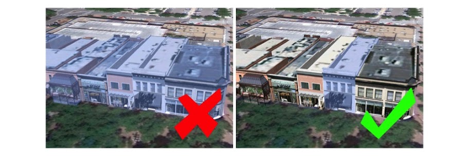
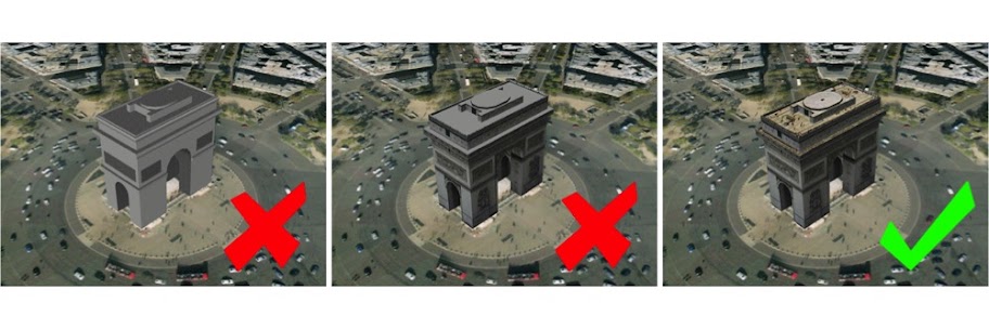 Our new minimum requirement for photo textures is more lenient than it’s been in the past. Photo textures are only required on upward facing surfaces of the model and on the main facade. We encourage you to photo texture the entire model, but we also understand that it may be difficult to get accurate imagery on every side of some buildings. Any remaining, non-photo-textured faces in your model should be painted with realistic-looking textures that match the color and look of the building in real life.
Permanent Structures
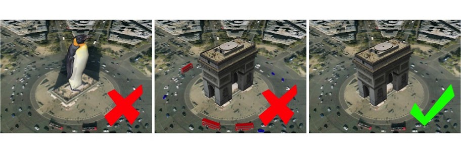 Beginning today, only permanent structures will be accepted. As we constantly refresh our satellite imagery, temporarily-positioned entities like vehicles and people don’t belong in Google Earth’s 3D Buildings layer.
Model Splitting
From now on, all submitted models should contain only one structure each. Each structure should be uploaded as a separate model file. This includes properties that have multiple buildings on them such as a house and a shed or garage. If buildings are all connected in a city block, they should be split into separate models based on building type, function or address. When our review team is assessing connected block models for splitting issues, we will look at the facade and roof textures to see if there are changes in material that signify where a split should have occurred.
Entourage
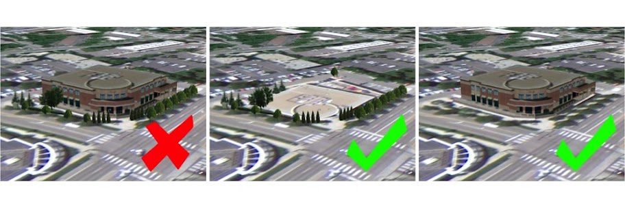
In addition to splitting buildings, we are now requiring all models of trees and other permanent entourage (such as signs, light posts and benches) to be uploaded separately from the buildings with which they may be associated. This ensures that when another building is uploaded in the same location, we are only judging the quality of the new building model versus the original. It’s a shame to have to remove good tree models just because they’re attached to a building model when a better building model is submitted that doesn’t contain trees.
Also, multiple, related trees and other entourage objects can be grouped into a single model as long as they are located in a relatively concentrated area. This means a single model can contain all the trees for a block or a park, but it shouldn’t contain all the trees for multiple blocks or an entire city. Remember that only permanent entourage is acceptable—cars and pedestrians move around, and thus don’t belong in Google Earth’s 3D Buildings layer.
Other improvements
One other big improvement we’ve made is the addition of tips and suggestions to each of the thirteen individual Acceptance Criteria. If a model you submit isn’t accepted, you’ll receive an email notification (opt into these emails via your preferences) that includes a direct link to concrete information about how you can improve it before you re-submit.
What about models that have already been accepted?
To help make this transition easier, we won’t be going through all the models we’ve already accepted in order to remove ones that fail to meet the new Acceptance Criteria. If your model has already been accepted, it will stay in the 3D Buildings layer until and unless it is sent through the evaluation process again. There are four actions which can cause a model to re-enter this process:
- You make an edit to your model and re-upload it to the 3D Warehouse, replacing the previous version.
- Someone else submits a model in the same location as your model.
- Periodic terrain and aerial imagery updates cause your model to go through our automated alignment process.
- Someone clicks the “Report a problem” link for your model in Google Earth.
It’s still a bit of a subjective process
Keep in mind that judging 3D models is still a difficult task and is prone to subjectivity. All submitted models are reviewed by real human beings who take time to ensure that they meet our standards. Because human beings sometimes make mistakes, we have a way for you to appeal negative judgements. If, after reviewing the Acceptance Criteria, you feel we’ve made the wrong decision, use the “Tell us why we’re wrong” link (at the bottom of the model’s 3D Warehouse page) to ask us to take another look. You’re encouraged to include links to photos of the actual building or other online resources to will help us to understand your point of view.
We know how much time and love goes into making beautiful 3D models for Google Earth, and we greatly appreciate all the effort you put into your work. Here’s hoping that the changes we’ve made will make for a smoother, more enjoyable geo-modeling process for everyone.