Explore university campuses in 3D and StreetView
As part of the continual additions to Street View, Google has just added more university campuses around the world to the product, bringing the total number of Street View-able campuses to nearly 100.
Combine that with the fact that thousands of new 3D buildings are added to Google Earth each week, along with 3D trees in a growing number of cities, and you have some excellent tools at your disposal to help browse around your favorite college.
For example, below is Stanford University shown in Google Earth and Street View so you can compare the views:
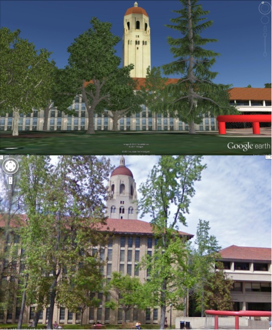
Google has spotlighted a few other universities in a recent blog post and you can view the full list of Street View-enabled campuses on their site.
You can also view some extra goodies at a few schools (like the virtual campus at Northeastern University) and utilities such as Campus Bird help provide more geo context for hundreds of schools.
As good continues to add Street View at more schools, and schools continue to work on their 3D buildings, this kind of exploration will only get better!
The Bing Maps Windows Presentation Foundation Control v1
Back in August, was announced the Beta for our Bing Maps WPF control. The uptake in the Microsoft Developer Community has been stellar and the feedback – immensely helpful. As a result and as promised to those across the Microsoft Developer Network, we’re officially releasing The Bing Maps Windows Presentation Foundation Control, Version 1.
The control was built atop of the beta, so we still have all of the touch enabled greatness for Surface v 2’s Pixel Sense, inertia and full rotation. We’ve kept most of the classes, methods and properties in place from the beta – requiring little work to install and register v1. And, per community feedback on the Bing Maps MSDN Forums we added the following features (and fixed a few bugs):
- Support for tile layers – you can now overlay your own tile layers atop the map control.
- Turning off the base tile layer – this is useful for when you don’t need/want to use our base map tiles and instead would prefer to use your own without overlaying them atop of ours. The control won’t request the tiles which reduces downloads and improves rendering performance.
- SSL Support – since many of you are using the WPF control in secure applications, you can now make tile and service request over SSL without issue.
- Hiding the scale bar – if you don’t want a scale bar (perhaps your map is small and the scale bar clutters the map) you can turn it off. In fact, the only elements you can’t turn off are the Bing logo and the copyrights.
- New copyright service – provides accurate copyright for our data vendors.
- Additional inertia – inertia is now enabled for the mouse and is on by default for touch.
- Miscellaneous bug fixes – thanks for the feedback on the MSDN Forums, the Bing Maps Blog, e-mail and Twitter. Good finds people.
I have to give it up for my (small) crack team of people involved in the making of the WPF Control. This was one of those 10% projects that we all really had a passion to get done because it was the right thing to do for the Microsoft Developer Community. So, we found the time, slipped the release a month (for quality) and, as the guys over in Surface said, “just got it done.” Our internal motto kept stoking the fire to push this bad boy out the door…”WPF, FTW!”
Now, download the Bing Maps WPF Control, build a killer app and make us proud.
