Google Earth: Protecting Canada’s Coast

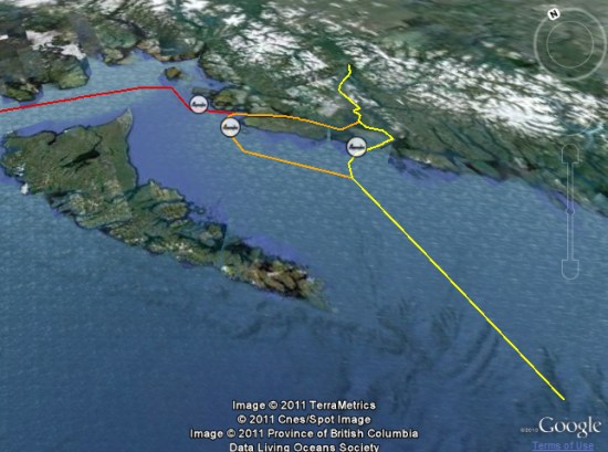
The Living Oceans Society is focused on protecting Canada’s Pacific coast from risks such as oil spills, salmon aquaculture and other industrial activity. As part of that, they’ve recently created an interactive map using the Google Earth Plug-in that focus on the oil risk for the coast.
 

living-oceans.jpg 

Enbridge, operator of the world’s longest crude oil and liquids pipeline, is planning the “Northern Gateway Pipelines Project”, which would create two pipelines between Alberta’s tar sands and a marine terminal in Kitimat, B.C. Once complete, roughly 220 supertankers would sail the area waters each year.

The Living Oceans map is an attempt to show a massive amount of data expressing the risk to the North Coast if the project goes through.

Visitors can view photos and facts about ecological features like salmon streams and eelgrass beds, critical orca habitat and sea lion haulouts. Other layers show the human presence on the coast, such as areas important for sport fishing and log harvesting and the locations of past marine accidents. Also available are layers showing local opposition to the proposed tankers, including the proposed tanker ban area. Through it all run Enbridge’s proposed tanker routes.

Regardless which side you support in a fight like this, Living Oceans Society has done a great job of using Google Earth to support their side.
New high-resolution underwater terrain in World Oceans Day

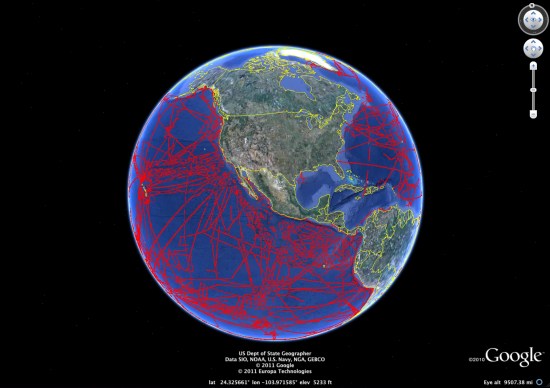
In celebration of World Oceans Day, Google has released a significant amount of brand new high-resolution ocean floor imagery, amounting to an area larger than North America!

Captured from nearly 500 ship cruises and 12 different institutions, the data was curated by the Lamont-Dohery Earth Observatory. The image below shows the areas that have been udpated:


world-oceans.jpg

To explore more of the new features, Google has created a “Seafloor Updates layer” to show off the highlights, seen here:

The deepest volcanic eruption ever recorded was at the West Mata volcano near Fiji, photos of which can be seen in the Deep Sea Vents Ridge 2000 tour. Coincidentally, Frank is celebrating World Oceans Day by spending a full day diving in the ocean in Fiji. You can read about that experience on the Tahina Expedition blog.

All of this data is fun to look at, but there are some important scientific benefits as well. In particular, a more detailed ocean map can help us understand how tsunamis will spread around the globe. At this point, we know more about the surface of Mars and the Moon than we do about the ocean floor, so advances like these are becoming more critical.

Sarawak: The damaged rainforest

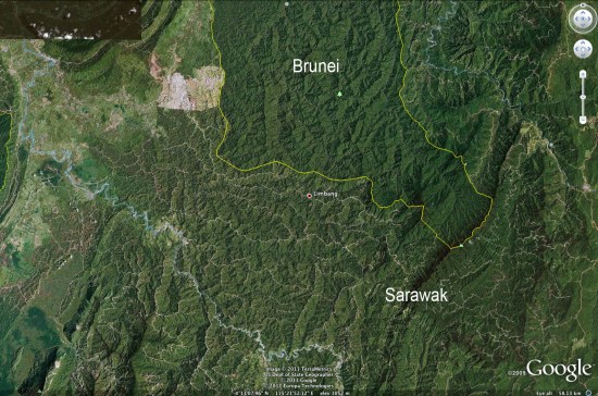
The state of Sarawak, in Malaysian Borneo, is the site of an interesting political battle recently. Their Chief Minister claims that 70 of Sarawak’s forest cover is intact, but imagery from Google Earth seems to indicate that it’s far worse than that. In fact, some environmentalist groups estimate that logging has cost Sarawak 90 of it’s primary forest cover.

Mongabay has written a very detailed article about this situation, including quite a few photos. For example, the image below clearly shows logging roads all throughout Sarawak, while virtually none are visible in Brunei to the north.


sarawak.jpg 

Google Earth is making it increasing difficult for governments to lie about this kind of behavior. As the pace and quality of imagery updates continue to improve, things will only get better for those that wish to expose this type of thing.

Be sure to read the entire article on Mongabay for more information and many more photos.