More Armchair Archaelogy using Google Earth

Back in 2006, Scott Madry made news by with some archeological discoveries in France, and was first given the name of an “armchair archeologist” to describe a person that uses Google Earth (or related software) to make significant archeological discoveries in other areas of the world.

More recent examples include the discovery of a buried Peruvian pyramid and meteor craters in Australia and the Saharan Desert.

However, today’s story takes those to a whole new level, with David Kennedy of Perth, Australia discovering nearly 2,000 archaeological sites in Saudi Arabia!

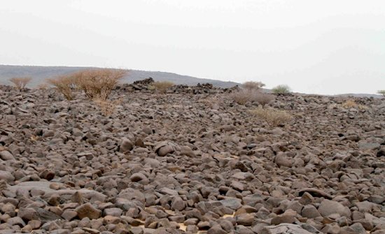
To be sure of what he was looking at, Kennedy had a friend in Saudi Arabia visit a few of the sites to make sure they weren’t just shadows or other natural formations. His friend was able to confirm his discoveries, as seem in the image below:

ground-level.jpg

Details of these finds and the methods used to uncover them have been posted in the Journal of Archaeological Sciences

As Curt Hopkins at ReadWriteWeb points out, tools such as Google Earth won’t allow archaeologists to do all of their work from a computer. However, we’ve already seen many examples of how data discovered in Google Earth can be used to pinpoint locations to dig, potentially saving many hours.

Hunting for the Megalithic Stone Circle in Morocco

Over the past few years, we’ve seen some great discoveries in Google Earth, including some quite remarkable finds that were only made possible thanks to the widespread high-resolution imagery that is available in Google Earth.

Some examples include a geologist that “accidentally” discovered a meteor crater, another crater in the Saharan Desert, and a buried Peruvian pyramid.

Today we bring you the story of Graham Salisbury, and how he was able to track down the megalithic stone circle of Mzora using a black and white photograph and Google Earth.

mzoura01.jpg

Salisbury quotes several sources as saying it’s “extraordinarily difficult to find” and “one would have to have access to a military satellite to find it“, but he felt that it could be found in Google Earth with enough research and patience.

You can read all of the details on his blog, but he did an excellent job of figuring out which area to search and then tracking down. If you compare the screenshot from Google Earth below with the black and white image above, I think it’s pretty clear that he succeeded.

mzora-ge.jpg

If you’d like to see it for yourself, you can fly there using this KML file.