Create a search engine for any purpose. This search engine can be implemented anywhere to search your website content, or to search pages on the web.
Google Earth continues to reveal strange sights from above
Over the years, we’ve seen a variety of interesting items revealed as result of Google Earth.
One of the most popular was the Swastika-shaped Navy Barracks that Frank first told you about in 2007. For years it was a simple building, but it gained fame once viewed from above, as it was clearly (though certainly unintentionally) shaped like a Nazi swastika.
Another great example was the huge scale model of China that was discovered. It represented an area that was occupied by China but claimed by India and was in dispute, and the model itself was nearly a square kilometer in size.
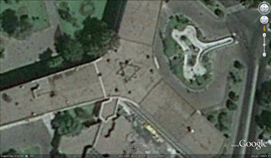
The latest example is the Star of David being discovered on the roof of the Iran Air headquarters. The building was constructed in 1979, and it seems that no one noticed the symbol until now. Unlike the Navy swastika building, this symbol was clearly intentional, though it’s unclear who placed it there.
Iranian government officials are quite upset by this, and plan to have it removed quickly. However, it may stay in Google Earth for a few years, or at least until the imagery in that area is updated again. If you’d like to see it for yourself, you can fly there using this KML file .
.
If you enjoy seeing strange items like this, there are a few categories full of fun items like this over at Google Earth Hacks: Crop Circles, Huge Man-Made Structures and Huge Symbols. You can also check out the great “20 Awesome Images Found in Google Maps” post by Search Engine Land,
For some Street View fun, try the Giant Items/Oddities category at GEH, or the Strange Things category at StreetViewFun.
Of all of the strange things you’ve seen in Google Earth, which is your favorite?
Geoportal Extension to Become Open Source
Despite code documentation and samples as included on the Geoportal Resource Center, implementers of the Geoportal Extension have continued asking for source code access to support integration with content management systems, map viewers, desktop etc.
Esri listened to these requests and I am happy to be able to announce that:
the Geoportal Extension will enter a next phase in its evolution and become a Free and Open Source solution from Esri.
Seven years ago we created what was then called the GIS Portal Toolkit as a software and services solution, based on code from a number of earlier projects and prototypes for data discovery and map viewing.