New panoramic photos in Google Earth


Viewing photos in Google Earth has long been a popular activity for avid virtual globe-trotters. It’s one of the best ways to “visit” places all over the world without paying for a plane ticket or getting jet lag. Today, the Google Earth photo viewing experience just got better with the addition of panoramic images.

People using Google Earth will find a new “Photos” layer that includes not only the existing 2D photos from the Panoramio community, but also panoramic photos from around the world contributed by users of 360cities.net. These high-resolution panoramic photos are marked in Google Earth as red square icons. When you click on one of these icons, an info bubble containing an image appears, and clicking on the image again will take you into our photo viewing mode. You can then look around in 360-degree views and experience the place as if you’re standing right at the center of it.

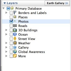
new “Photos” layer on Google Earth
info bubble on Google Earth

These panoramic photos are shot by average people just like you and me. To contribute your panoramic photos, visit 360cities.net. We invite all users to become part of the community and mark your photo journey in Google Earth.

Check out some of the beautiful images now available right in Google Earth.

Golden Gate Bridge on Google Earth and on 360cities.net
Gapang Beach, Pulau Weh, Indonesia on Google Earth and on 360cities.net

Lion’s Head, South Africa on Google Earth and on 360cities.net

Diving New Caledonia Amedee Island on Google Earth and on 360cities.net

Umag Asanas, Istria at sunset on Google Earth and on 360cities.net

Panthéon and Foucault pendulum, Paris on Google Earth and on 360cities.net

Posted by Wei Luo, Senior Geo Data Strategist

Costa Rican-Nicaraguan Country Border Updated on Google Earth

Last week, we were informed of a data error regarding the border between Costa Rica and Nicaragua in Google Maps. We said we would update our data for this region. We have now updated the border data on Google Earth, and we are working on updating this border on Google Maps as well.


As always, you can report errors about Google Earth through our Data Reporting Page or about Maps through the Report a Problem tool, where available.

Posted by Wei Luo, Senior Geo Data Strategist

Imagery Update – Week of November 1st

The Google Earth and Maps Imagery team has just released another extensive batch of aeriel and satellite images for your enjoyment! In honor of the upcoming U.S. holiday Veterans Day (November 11th), we’ll take a look at a few military-themed museums.

Let’s start with a wide-view of the naval ships on display at the Baltimore Maritime Museum in Baltimore, Maryland. Historic ships that you can zoom in on and see close up in Google Earth or Maps include the last sail-only warship USS Constellation (lower left); the submarine USS Torsk (upper left) which sunk the last enemy ship in World War II; and the cutter USCGC Taney (upper right), the last ship still floating that fought during the Pearl Harbor attack.

Baltimore Maritime Museum in Baltimore, MD

Now that we’ve got our sea legs, let move sub-orbital and beyond at the U.S. Space and Rocket Center in Huntsville, Alabama. Here we can see a restored Saturn V-1 “moon shot” test vehicle and the A-12 Oxcart “Blackbird” spy plane.

U.S. Space and Rocket Center in Huntsville, AL

These are just a few examples of the many museums around the globe that are included in our latest imagery batch.

High Resolution Aerial Updates:
USA: Baltimore, Cedar Rapids, Huntsville, Long Island, Redding, Springfield (IL), St. Joseph (MO)
Austria: Schladming
Finland: Pori
Ireland: Athlone, Drogheda, Dundalk, Enniscorthy, Galway, Limerick, Monaghan, Tralee, Waterford,
Spain: Vasco

Countries receiving High Resolution Satellite Updates:
Albania, Algeria, American Samoa, Angola, Argentina, Armenia, Australia, Austria, Azerbaijan, Bangladesh, Belarus, Benin, Bolivia, Botswana, Brazil, Bulgaria, Burkina Faso, Burundi, Cameroon, Canada, Central African Republic, Chad, Chile, China, Colombia, Costa Rica, Cuba, Côte d’Ivoire, Democratic People’s Republic of Korea, Democratic Republic of the Congo, Ecuador, Egypt, El Salvador, Equatorial Guinea, Eritrea, Ethiopia, Finland, Former Yugoslav Republic of Macedonia, France, Georgia, Germany, Ghana, Greece, Guatemala, Guinea, Guinea-Bissau, Guyana, Honduras, Hungary, India, Indonesia, Iran, Ireland, Kazakhstan, Kenya, Kyrgyzstan, Lesotho, Liberia, Libya, Madagascar, Malawi, Malaysia, Mali, Mauritania, Mauritius, Mexico, Moldova, Mongolia, Montenegro, Morocco, Mozambique, Myanmar, Namibia, Nepal, New Zealand, Nicaragua, Niger, Nigeria, Norway, Oman, Pakistan, Panama, Paraguay, People’s Republic of the Congo, Peru, Philippines, Poland, Portugal, Romania, Russia, Rwanda, Saudi Arabia, Senegal, Sierra Leone, Somalia, South Africa, Spain, Sudan, Suriname, Swaziland, Taiwan, Tajikistan, Tanzania, Thailand, The Bahamas, Togo, Tonga, Tunisia, Turkey, Turkmenistan, Uganda, Ukraine, United Arab Emirates, United Kingdom, United States, Uruguay, Uzbekistan, Venezuela, Vietnam, Yemen, Zambia, Zimbabwe

These updates are currently only available in Google Earth, but they’ll also be in Google Maps soon. To get a complete picture of where we updated imagery, download this KML for viewing in Google Earth.