Protecting the world’s coral reefs through mapping

Editors Note: Today’s guest author is Katie Reytar, a Research Associate for the World Resources Institute. WRI was the recipient of a Google Earth Outreach Developer Grant, funded through the Google Inc. Charitable Giving Fund at the Tides Foundation. We’re excited to help them share and visualize the results of years of research about the state of the world’s reefs.

Since 1998, the World Resources Institute (WRI) has been using GIS (Geographic Information System) models to develop map-based assessments of threats to the world’s coral reefs. Reefs at Risk Revisited, released in February 2011, is the latest assessment in the series and is based on a nearly three-year study that produced the most highly-detailed global maps of coral reef threats to date. The study analyzed and mapped threats to coral reefs from local human activities such as coastal development, unsustainable fishing, and marine and land-based pollution, as well as climate-related threats caused by increasing levels of greenhouse gases in the atmosphere.

While the Reefs at Risk Revisited report, maps and data sets are the core components of our work, we found ourselves still searching for a compelling way to convey our findings on these dynamic yet fragile reef ecosystems. We also wanted to generate greater awareness of the unique characteristics of reef habitats across different geographies and the irreplaceable cultural and life-sustaining services that reefs provide to people all over the world. All of these elements are best communicated when you can see them for yourself, which is why we created a virtual tour of these reefs around the world with our Google Earth Outreach Developer Grant.


Watch a virtual tour of the most at-risk reefs in the world courtesy of the World Resources Institute.


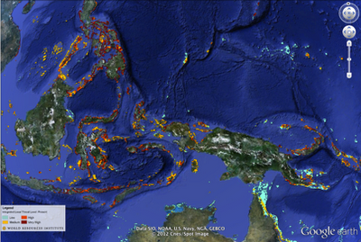
In the tour, the Reefs at Risk Revisited maps come alive on Google Earth with photos and underwater video from each of the major coral reef regions of the world: the Caribbean, Middle East, Indian Ocean, Southeast Asia, Australia, and Pacific, as well as a global-level introduction and conclusion. The journey to each region provides a brief overview of the biodiversity of reef ecosystems, their importance to people and local economies, and the types and magnitudes of threats that reefs face, illustrated with footage of both healthy and damaged reefs.

You’ll also experience first hand these fantastically dynamic and productive ecosystems that extend across about 250,000 sq km (96,500 sq miles) of the tropical ocean. Even though this area represents less than 0.1% of the global ocean, reefs are home to as many as 25% of all known marine species. In the tropics, coral reefs are not only a critical habitat for marine species, but they also play an essential role in the lives of millions of people who live near them: they provide food and income from fisheries, revenue from tourism, and protection for coastal communities from storm surges.

Among the other products of the Reefs at Risk Revisited project are global maps of coral reefs rated according to level of threat in the present, 2030, and 2050. These maps are available as downloadable KML files on the WRI website for viewing on Google Earth, and also as part of an online map developed using Google Fusion Tables. With these interactive maps you can zoom in to your favorite reef to explore it more closely in your own self-guided tour.

Explore Reefs at Risk Revisited in Google Earth.

We hope that you enjoy our tour and maps, and that you are able to visit a coral reef to learn more about these important and unique ecosystems. With improved understanding, we can manage and protect these resources so that we can all enjoy them and benefit from them for generations to come.
Four New Bing Maps V7 Modules

In September of 2011 Bing started the Bing Maps v7 Module CodePlex Project. The purpose of this project is to create a single place where developers can find and share useful modules that expand the functionality of the Bing Maps V7 API. Currently, there have been 10 modules submitted to the project. With a number of new modules in development, it’s safe to say that this project is definitely worth looking into. Today I would like to highlight the four newest modules added to this project.

Point Based Clustering Module

Download here

Bing created this module based on feedback received around the Client Side Clustering Module that  created some time ago. The older client side clustering module uses a grid based algorithm which is fast, but requires re-clustering the data every time the map moved. This allows for 5000+ pushpins to be clustered in a fraction of a second but often results in pushpins jumping around the map as you pan. The point based algorithm prevents pushpins from overlapping and jumping around by only clustering the data when the zoom level changes. Additionally this module keeps track of clustered information for each zoom level, making the algorithm faster the more you use it. This improved UI experience does affect performance and as such this algorithm is recommended for 2000 or less pushpins. Interested in reading more about how this algorithm was created? Check out this blog post.

GPX Parser

Download here

Bing created this module due to a number of requests that had received for such a module. This module allows you to easily pass in a URL to a GPX file and have it parsed into an EntityCollection which you can then render on Bing Maps. GPX is a type of XML file that is commonly used by GPS devices. It can be used to describe waypoints, tracks, and routes. Majority of the XML tags for V1 and V1.1 of the GPX schema are supported and all data is stored in a Metadata property, which is added to each entity.

Route Optimization – RouteSavvy Module

Download here

This module was created by OnTerra Systems, a Bing Maps Partner.

In today’s economy, it is more important than ever that companies optimize and manage their supply chains more efficiently. Given today’s fuel costs, product delivery with high quality of service and short delay times is paramount. Distribution accounts for a large proportion of the overall operational costs of a producer. Hence, effective and efficient management of transportation and distribution of goods are becoming increasingly important.

One of the key problems in this process is the optimization of delivery routes to customers. This problem is known as the “Travelling Salesman Problem” (TSP). RouteSavvy is a web service that helps solve this problem.

RouteSavvy is a simple but powerful tool that can take anywhere from 3 or 4 locations to hundreds of locations. It reorders them based on whether you’d like to visit them in a “round-trip” OR as a one-way trip, with the last stop chosen either by you or by the software (whichever is preferred).

Web developers can now easily integrate the RouteSavvy API into their web application by adding the RouteSavvy Map Module. The map module uses Ajax to call the RouteSavvy web service to optimize a given set of locations.

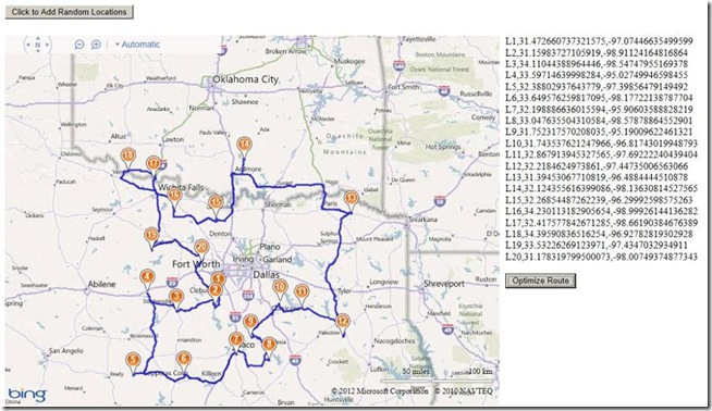
Here is a screen shot of a set random location optimized for a round trip:

Mini-Map Module

Download here

This module was created by OnTerra Systems, a Bing Maps Partner.

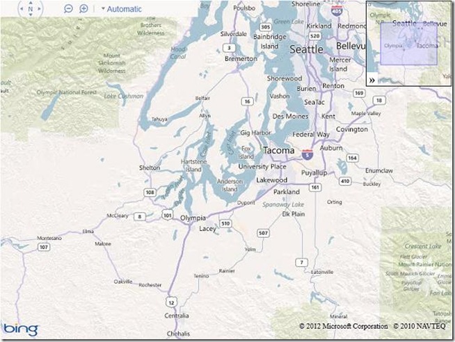
The Bing Maps Ajax v7 control doesn’t include support for adding a Mini-Map. The Mini-Map module adds a small map at the right corner of the parent map that’s collapsible and shows the extents covered by the current map. This module adds a mini map at the top right corner of the screen. Mini-map view helps to give a zoomed out overview of your location. Here is a screen shot of the implemented Mini-Map module:

I hope you find these new modules useful!

The Microsoft 311 Service Center with Bing Maps


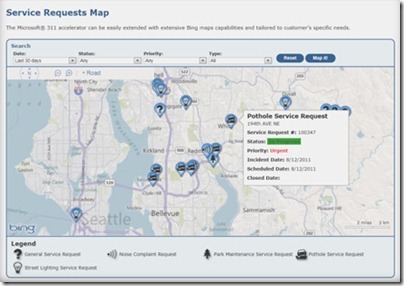
Microsoft now has an all-in-one fully integrated solution for city governments with the 311 Citizen Services Center. It combines the power of several Microsoft technologies and has both a citizen-facing portal and a back-end management module, including interactive Bing Maps for both components. When cities use the 311 service center, citizens can easily report outages, potholes, etc. by locating them on a map. City workers and contractors can use Bing Maps for service request information and updates. 311 Service Center is another great example of how Bing Maps integrates with

Microsoft Dynamics® CRM to show the data the customer is managing, and to speed up the decision process.

To learn more about how your city can benefit from the Citizen Services Center (311), visithttp://www.microsoft.com/gov311 and watch this video.


Citizen-facing portal with self-service and multi-access channels