SightSpace 3D

Have you ever wanted to take your SketchUp models on the go? Our friends at the Boulder-based start-up, Limitless Computing, have a solution for you: their recently released SightSpace 3D app allows you to view SketchUp models on the iPad, iPhone, or iPod (Android support coming soon).
I gave it a whirl and the viewer is quite good. Orbiting a SketchUp model with single finger, panning with two, and pinching to zoom in and out is very satisfying. Loading models onto your mobile device is easy too; the Google 3D Warehouse is integrated in the app and you can also load models through Dropbox and email.

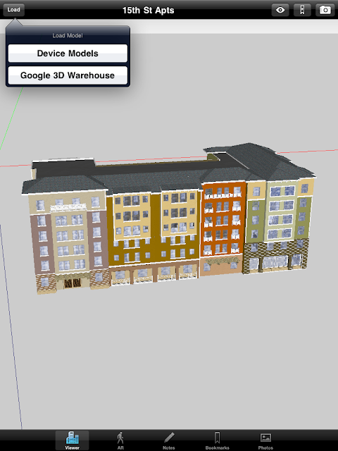
The 3D Warehouse is integrated into the app making it easy to load models

The mobile viewer would be neat enough, but SightSpace 3D’s killer feature is the Augmented Reality (AR) viewer, which gives you the ability to overlay 3D models onto the physical world. Any geo-located Google SketchUp model can be exported to a KMZ file, placed on an iPad 2 or iPhone 4, and viewed in real-time, in a real place letting you actually walk through the space. As you can imagine, this is useful for previewing construction projects, displaying kitchen designs, urban planning and much more.

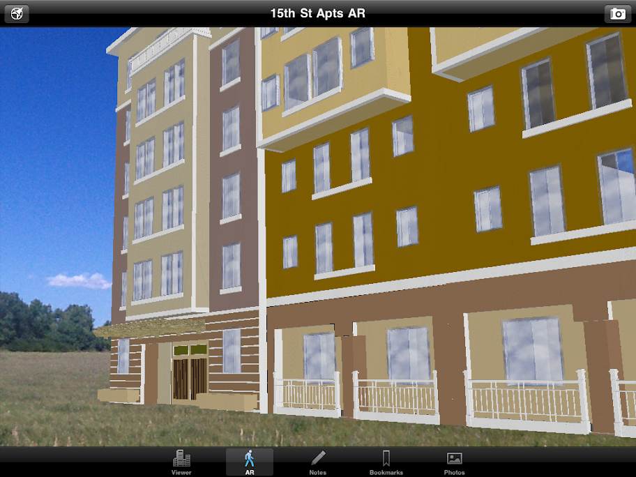
An apartment complex is superimposed on undeveloped land, to scale. (Model courtesy of Hilliard Architects, San Francisco, CA)

Additional features include bookmarking views, taking snapshots in both Viewer and AR mode, and the ability to annotate and email notes directly from the app.

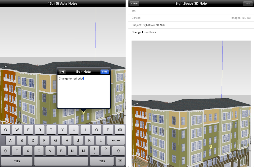
Annotations and photos of a model get added directly to an email

SightSpace 3D is available now in the iTunes store now for $15 US, so go download it today.

Data.gov Adds Geoviewer

Today, Data.gov added a new capability to its growing arsenal of tools that allow for using the data the website makes accessible. The so-called Data.gov GEO Viewer has some interesting capabilities:

  • Data loaded into viewer in Real-time through web URLs – the viewer downloads data directly from the authoritative source. An ArcGIS Server Geoprocessing service uncompresses data if needed (.zip, .gz, .tar), transforms data to JSON, and streams this back to the flex viewer.
  • The GEO Viewer loads data in Web Mercator (if data or service supports it).Otherwise the GEO Viewer changes its basemap projection to Geographic Coordinate System and loads the data.
  • The viewer supports the following data types:
    • Map Services: OGC WMS, ArcGIS
    • Feeds: GeoRSS
    • Files: KML/KMZ, Shapefile
  • The GEO Viewer allows for mashing up multiple datasets, map services, and feeds in one view. It supports basic navigation using the keyboard (without the need to use the “shift+alt+F7+drag the mouse+release alt and mouse button at the same time”-like features…).
  • Set a basic color for the added data layer, set transparency for the layers, and use a swipe/see-through feature.
  • Basic identify operation on the added data.
  • Switching the basemap.

There are some limitations with this viewer, most of which are due to the fact that it downloads data from the source every time someone wants to see it:

  • File size limit of 10MB – Shapefiles and KML files can have large compression ratios. While the registered file in Data.gov may be an under 10MB KMZ file, this can easily expand into a 100MB KML that then is streamed as JSON features to the client. This simply takes time.
  • The information about the files is not enough to make an upfront assessment of whether the file is viewable or not. Almost every file in Data.gov is a .zip file. The GEO Viewer has to determine if it’s dealing with an Esri Shapefile, OGC KML, Arc/Info Export (e00, remember these?), Microsoft Excel, CSV, or whatever format(s) until after it downloads the file. The metadata in neither raw data catalog nor geodata catalog includes this information. A result is that sometimes users will only be notified that the file type is not supported until after the viewer is launched.
  • Registration of content is not readily usable by an application (James Fee found one of these…). There are several registrations of content that link to web pages or web applications, rather than the actual data. In this case, the content is however also available as an ArcGIS Server Map Service (although that’s not in the registration in Data.gov).

Няма актуализации за Windows и IE през този месец

Както знаете, от Microsoft пускат актуализации на продуктите си през всеки месец. Обикновено обновленията се отнасят за операционните системи Windows и офис пакетите на редмъндската компания. Тези актуализации се появяват във втория вторник на всеки месец. Както сами се досещате, на 9 ноември ще пристигне нова „доза“ от ъпдейти.

Този месец има три бюлетина, които поправят 11 уязвимости в Microsoft Office и Microsoft Forefront Unified Access Gateway. Един от тях е класифициран като критичен. Няма актуализации за Windows.

Ъпдейтите ще поправят уязвимости в следните продукти:
• Microsoft Office XP SP3;
• Microsoft Office 2003 SP3;
• Microsoft Office 2007 SP2;
• Microsoft Office 2010 (32-bit & 64-bit);
• Microsoft Office for Mac 2011;
• Microsoft PowerPoint Viewer;
• Microsoft Forefront Unified Access Gateway 2011 (включително Update 1 & 2).

Microsoft Office for Mac 2011 се появи пазара едва през миналата седмица, а вече има обновление за пакета. Същият ъпдейт, обаче, е пуснат и за Windows-базираните версии на Office.

Интересното тук е, че това е първият месец от цяла година, в който няма да има актуализации за Windows. Освен това, стана ясно, че наскоро съобщената уязвимост в Internet Explorer няма да получи поправка.