Google Earth: New Imagery – August 14


Thanks to sharp-eyed GEB reader ‘Andreas’, it seems that Google has just pushed out a fresh imagery update. The full extent of the update is still unknown, but it appears to be quite sizable.


omaha.jpg 

As is usually the case, you can use Google Maps to determine for sure whether or not a specific area is fresh. This new imagery isn’t in Google Maps yet, so you can compare Earth vs. Maps to see what’s new; the fresh imagery is already in Google Earth, but the old imagery is still in Google Maps. If you compare the two side-by-side and they’re not identical, that means that you’ve found a freshly updated area in Google Earth!

[UPDATED – 13-August, 1:52pm EST]

  • China: Beijing, Shenzhen — thanks ‘drone’ and ‘hongxz’
  • Ethiopia: Gode — thanks ‘Snakeye’
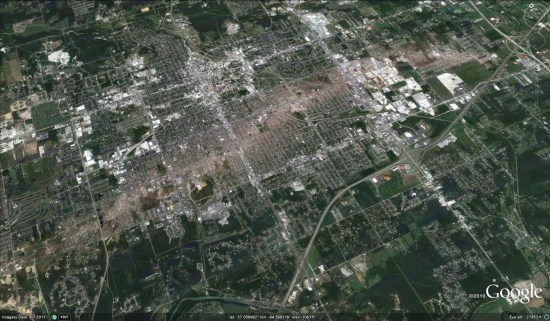
  • United States: Arizona (Buckeye, Camp Verde, Casa Grande), California (Bakersfield, Coalinga, Huron, Sacramento, Visalia), Illinois (Harrisburg), Iowa (Des Moines, Sioux City), Missouri (Columbia, Jefferson City, Joplin), Nebraska (Lincoln, Omaha), New Mexico (Carlsbad, Farmington), New York (Rochester), Ohio (Dayton), Oklahoma (Tulsa), Texas (Abilene, Big Spring, Dalhart, Junction, Monahams) — thanks ‘Alex’, ‘Andreas’, ‘Munden’ and ‘Steven’

As ‘Munden’ points out in the comments, the imagery from the tornado that struck Joplin, MO is stunning:

joplin.jpg 

Google Earth: New Imagery – May 31

Google has just dropped some more fresh imagery on us! Thanks to GEB reader ‘Munden’ for being the first to spot it!

huntington.jpg


As is usually the case, you can use Google Maps to determine for sure whether or not a specific area is fresh. This new imagery isn’t in Google Maps yet, so you can compare Earth vs. Maps to see what’s new; the fresh imagery is already in Google Earth, but the old imagery is still in Google Maps. If you compare the two side-by-side and they’re not identical, that means that you’ve found a freshly updated area in Google Earth!

[UPDATED – 1-June, 7:39am EST]

  • Chile: Temuco — thanks ‘Rodrigo Pastor’
  • France: Vannes — thanks ‘yves’
  • Japan: Hachioji — thanks ‘Munden’
  • Norway: Preikestolen — thanks ‘Andreas’
  • Romania: Timisoara — thanks ‘cristi’
  • United States: California (various areas), Indiana (South Bend), New Hampshire (Manchester), West Virginia (Huntington) — thanks ‘cristi’, ‘Jonahrf’ and ‘Munden’

Sound Transit: Riding the Bing Maps Wave

SoundTransit_0Sound Transit has launched their new public transit system featuring Bing Maps and leveraging their repository of public transit information to create a trip planner for Seattleites to get around town. The application allows users to put in origin and destination addresses, set the date and time (defaulting to the current date/time) and start planning their trip. So, let’s say I wanted to travel from the Bellevue Art Museum (510 Bellevue Way NE, Bellevue, WA) to the Seattle Art Museum (1300 1ST AVE, Seattle) – working on that Warhol foursquare badge. So, I input the respective locations, click “Plan Trip” and out pops a map with the full route charted right across the 520 bridge. They’ll soon need to account for the tolls…anyway. Grrr.

SoundTransit_1

The results also include several options with travel time, start and end times, the cost of the trip, the route numbers you’ll need to take, plus any transfers required to get from one museum to the other. Upon drilling down into the trips, you’ll see that there are actually different prices per rider type (adult, youth and senior/disabled) and whether or not you can use your ORCA card (One Region Card for All – basically, one card for all public transportation around Seattle). One of the many perks of being a Microsoft employee is a free ORCA card, so come work for us (!!) or ask more Microsoft people why they aren’t using public transportation since it’s free and there’s a kick ass Microsoft system powering the Sound Transit Trip Planner…just sayin’.

I digress.

Finally, in the trip planner, you’ll also see the distance you may have to walk in the rain (eek!) and then step-by-step driving directions with times included and the transit system which powers the mode of transport.

You’ll also notice some markers on the map. In addition to the route line and stops, there are buttons to enable Fare Outlets (for buying passes) and Park and Rides pinned to the map. These will be quite useful in our attempts to stop the insanity of $4 per gallon gas and global warming. A great addition to the Bing Maps Customer Showcase and a win for Sound Transit riders around Puget Sound.

Don’t live in Seattle? Build your own transit app. Sign up at the Bing Maps Portal.