Mapping History with Google Maps

Maps & Motion


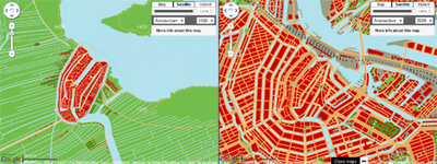
Maps+Motion is a great way to visualise the growth of Dutch cities and Manhattan in New York with Google Maps.

Essentially the application allows you to view side-by-side the modern maps of cities with maps of how the cities looked at different times in history. The screenshot above, for example, shows a map of 1450 Amsterdam with a modern map of the city.

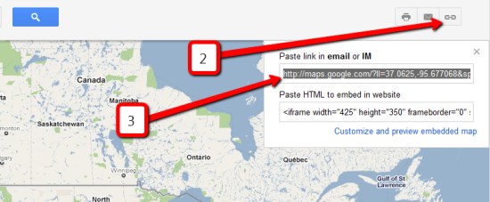
The application currently allows you to view the historical growth of Den Haag, Harrlingen, Amsterdam, Leiden, Rotterdam and Zuiderzee in the Netherlands and Manhattan in the USA.

How to export to KML from the new Google Maps?


As part of the recent Google Maps redesign, the ability to export your map to KML was mistakenly removed. According to a post in the Google Maps support forum, the feature will be added back in to Google Maps as soon as possible. In the meantime, here’s a workaround for you:

1 — Set the map the way you’d like it.

2 — Click the “link” icon in the top right corner.

3 — Copy the link below the “Paste link in email or IM”.

4 — Paste the address into your address bar and then add &output=kml to the end of it.

The image below helps explain how steps #2 and #3 work:

export-map.jpg 

No timeframe was given for the return of the KML link, but I expect they’ll fix it fairly soon. Let us know if you have any trouble getting this workaround to work for you.

Create Indoor Shopping Mall Maps

Google I/O App for Android


For the Google I/O conference this year Google created a pretty cool Android App that included a number of features, including a schedule, details about the sessions, buzz about I/O via a real-time search stream and a conference map.

Google has now open-sourced the code for the app. If you want to create a similar app for a conference you can download the code and adapt it to suit your needs.

One of my favourite presentations from Google I/O this year was Map Your Business Inside Out by Brendan Kenny and Chris Broadfoot of Google. Essentially in the presentation Brendan and Chris demonstrated how the Google Maps API can be used to create indoor maps for large conference centers or shopping malls.

You can view the presentation in full in this video:

In the presentation Brendan and Chris explain how you can attach floor-plan overlays to a Google Map, how you can label the floor-plan and how you can develop custom Street Views for your map.

If you are interested in creating your own indoor map then you might find these resources useful: