The Art of maps:Matthias Quad – Map of North America 1593

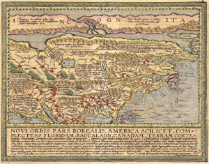
Matthias Quad - Novi Orbis Pars Borealis

Title: Novi Orbis Pars Borealis, America Scilicet, Complectens Floridam, Baccalaon, Canadam, Terram Corte…1585…


Map Maker: Matthias Quad

Place / Date: Cologne / 1600

Coloring: Hand Colored

Size: 12 x 9 inches

Condition: VG+

Price: $3,500.00

Description:

Striking example of Quad’s map of North America, based upon De Jode’s landmark map of 1593.

Jode’s map is one of the earliest maps to concentrate on North America alone. For his map, De Jode condensed information for the map from Dutch wall maps of the late 16th Century De Jode was the first to make use of both John White and Jacques le Moyne’s east coast cartography, although he inaccurately placed it. Quad here continues the mistake of placing the nomenclature of Virginia too far north. A long narrow waterway to the north represents the North West Passage; Lago de Conibas is also indicated. Some names have been surprisingly left out, notably Bermuda, St. Augustine, Roanoke and Chesapeake. A curious ‘second’ peninsula is shown to the west of Florida which could be an early depiction of the Mississippi delta.

The descriptive text below provides a brief overview of the history of North America to date. The projection of California and the West is packed full of annotations and place names. The headwaters of the St. Lawrence extend to Cibola in the mythical Southwest.
Free map service preview

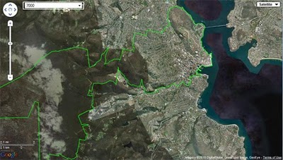
I am rushing the release of my latest free service offering from aus-emaps.com due to high level of interest in accessing postcode and other administrative boundaries data on a reference map that can be dynamically called from external sites. At this stage the free map service is more like a preview release rather than the real thing but it is good enough for a “show and tell”. The full concept behind this service is rather a long story so I will leave it for a more appropriate occasion. For now I will just limit the description to a short statement that it is intended as a free reference map, for embedding into website or linking to, to share location specific information.

Currently it works only with kmz files that can be referenced from anywhere on the world wide web and postcode boundaries from aus-emaps.com. It accepts single and multiple kmz files, as per examples below.

Here are a couple of examples of kmz files with complex information: in this case, Victorian bushfires aftermath (public file extracted from Google MyMaps): http://www.aus-emaps.com/svs/ref/map.php?
kmzl=http://www.aus-emaps.com/data/VictorianBushfiresFeb2009.kmz

And here is an example of kmz file showing the latest world earthquakes from USGS: http://www.aus-emaps.com/svs/ref/map.php?
kmzl=http://earthquake.usgs.gov/earthquakes/catalogs/eqs7day-age.kmz

Finally, a simple example of referencing Australian postal boundaries map from aus-emaps.com:
http://www.aus-emaps.com/svs/ref/map.php?
kmzl=2601,2220,7000,3122,5000&svs=2,2,2,2,2

Width and height of the map can be easily controlled by adding the following parameter to the URL: &wh=500,400 (size in pixels). Map type selection is with &mt=0 parameter (valid numbers are 0 for street map, 1 for satellite overlay, 2 for hybrid map and 3 for terrain map). This is just a quick demo of basic capabilities to give you a taste of what is possible with a very basic deployment of Google Map API (this one is still running only on version 2). More on this service soon.