about a small and beautiful island
NSW traffic conditions map
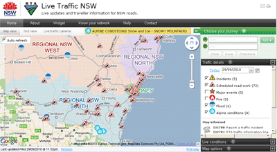 Road Traffic Authority (RTA) in NSW has stared publishing up to the minute information about traffic conditions in Sydney as well as in NSW regional areas. The coverage and extent of information is quite comprehensive and it is served in two formats to suit individual preferences: as an interactive map with continuously updated information, and as a text list (with sort function to enable arranging information according to update time, type of incident or its location). A separate window lists 67 live traffic cameras strategically located across Sydney’s road network, with images refreshed every few minutes.
I find map option the most informative as it displays all the data in geographic context. Information on the map is refreshed automatically with update time clearly marked. Auto update can be turned off if required and users can customise the list of information items for display on the map.
Live updates include information on accidents, scheduled road works, major events, fires, floods and Alpine conditions. There is an option to add traffic flow overlay for Sydney provided by Google as well as locations of live traffic cameras and temporary message signs.
Journey planner, utilising Google driving directions script, is part of the application. The map comes with a comprehensive list of points of interests that are very handy for planning a trip. These include: bike parking areas, heavy vehicles checking stations and rest areas, locations of Safe-T-Cams, general rest areas and RTA Motor Registries. Travel routes can be filtered to avoid incidents or road works on specific dates and can be saved for future reference.
RTA provides RSS feeds of the information on region by region basis. However, despite the push by Federal and State governments to liberate access to data generated by their agencies under creative commons licence, RTA is not letting developers to use its information for value added services and derived products. It is strictly for personal use although, embedding of the entire application in third party websites is allowed. A comprehensive widget customisation tool is provided as a part of the application, with easy to follow instructions.
Overall, this is quite a comprehensive information source, with attractive multi tab design and extensive range of features. The mapping functionality of the application is built with Google Map v2. Mobile version would be a great extension.
Free postcodes with Reference Map
Following on from my yesterday’s announcement about free reference map service – just a quick post on how to take advantage of free postal boundaries data that come pre-packaged with it.
To view on a map any of 2,507 postal area boundaries at full resolution (as defined by the Australian Bureau of Statistics for Census 2006 population and housing data) just follow this simple URL pattern:
http://www.aus-emaps.com/svs/ref/map.php?kmzl=2000&svs=2
Multiple postcodes can be added to the map as follows (at this stage one at a time only):
?kmzl=2000,3000&svs=2,2
A set of simple instructions on how to configure other map parameters can be found on aus-emaps.com web widgets page.
Since this reference map can be embedded in a website page, a simple javascript code can add additional functionality to render the content dynamically. It means you can now start serving postal boundaries and/or any other data in kmz or geoRSS format directly on your web site! Here is a link to a simple example showing you exactly how to do it.
And this file will also be handy to script the functionality: list of postal areas (Census 2006 version in csv format). Please note, Northern Territory postal area boundary data are named with leading “0” (ie. 0800).