Paine on Watching Yourself

Character is much easier
kept than recovered.”

–Thomas Paine (1737–1809)
American political theorist & writer

Email this quote

Sales character…

When you and your team are working with your prospects and customers (which should be about 85% of your time), remember that gray areas of communication can present serious challenges to the mutual trust level of your long-term relationships. Work to eliminate any omissions in your communication and be sure that all possible gray areas of understanding are minimized (it’s the truth piece of loving your people).

When you have a moment, invest some time (outside the money hours, as always) in a “gray and omissions check” of your standard sales statements, presentations, and other regular sales communications.

Think long-term as you develop your customer relationships and you’ll always be one of the best in the business… long-term.

_____

A couple other thoughts for the holiday season…

How to better remember the names of people you meet at parties and events and how to keep your edge (and avoid becoming Monday morning’s water cooler talk).

Supermodeler Story: Zeljko Zdravkovic

Here’s a testimonial from Zeljko Zdravkovic (a.k.a Zex), who told us about his experience geo-modeling his hometown of Belgrade, Serbia.

I started modeling Belgrade because I wanted to create a 3D identity for my city. I first learned that it was possible to add a 3D building to Google Earth several years ago. I was very surprised and curious about this. I had also noticed a number of untextured models in Belgrade, and decided that I wanted to change that.

As is often the case when learning something new, I experienced many false starts. I didn’t know how to use SketchUp, or, publish a model to Google Earth. I tried and tried, in failure. It wasn’t until I noticed a little checkbox labeled “Google Earth Ready” that I realized why my models where not appearing! I laugh about it now, but it was very frustrating then!

I started to make 3D models in the summer of 2009. Today you can see over 500 models that I’ve made. When combined with the work of other geo-modelers, there are over 800 models in Belgrade, and almost 1200 models in all of Serbia (including Belgrade).

With the exception of some buildings and monuments, I’ve finishing nearly 90% of the city area. I’m hoping to complete the entire city by the end of 2011 or beginning of 2012.

Unfortunately, Belgrade area is not available in Building Maker today. If it were, it would certainly have been far faster and easier. But when I finish the entire city, Belgrade is going to be one of the most quality-built 3D cities in Google Earth, and that’s something that I take a lot of pride in—for me, model quality is number one!

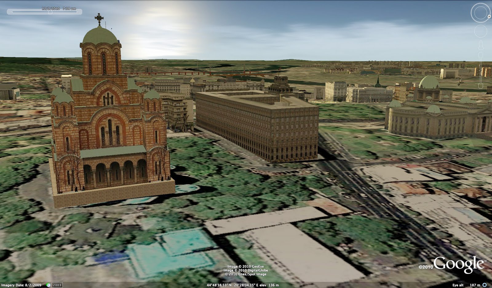
Црква Светог Марка (St. Mark’s Church)

Google Earth is an excellent opportunity to promote your city to other people all over the globe. 3D models can benefit a city a lot. People all over the planet can see, learn from and enjoy the architecture of every building we make.

City TV Studio B now uses 3D “New Belgrade” area in Google Earth for traffic service information on their web site. They use a 3D map in their television broadcast. It’s such a fantastic feeling when you see your 3D models on TV, or used by others for very useful purposes.

It is so amazing how Google Earth has enabled the world to become so personal to us. Now anyone can visit every corner of the globe. It’s really amazing to me!

Google Earth Engine, an amazing tool for scientists and researchers, released at COP 16

Yesterday at the International Climate Change Conference, Google released a mountain of data for scientists around the world to analyze and use. Known as “Google Earth Engine“, it gives researchers access to this huge pile of data, along with computing power to deal with all of it.

The data includes Landsat satellite data and “trillions of scientific measurements” covering the past 25 years.

So what can be done with all of this data? Thanks to some launch partners, there are already a handful of projects underway. For example, below is a map showing the loss of forest cover in the Congo for the past 10 years, taken from the Earth Engine Map Gallery.

congo.jpg

To go along with this, Google is also donating 10 million CPU-hours for each of the next two years, to help developing nations track the state of their forests. This is in anticipation for REDD (Reducing Emissions from Deforestation and Forest Degradation in Developing Countries), which offers financial incentives for tropical nations that protect their forests.

Do you plan to use Google Earth Engine? If not, what would you use it for if you had the chance?