Google Summer of Code & OpenIntents


This year was the first year OpenIntents participated in the Google Summer of Code. We are an open source organization which creates software for Android mobile phones and tablets, with special emphasis on interoperability with other software components.

As an organization we’ve found involvement in the Google Summer of Code extremely rewarding. The students have been able to improve their skills and gain practical experience in the stages of a software project, our organization has benefited from the interest generated from the students’ work, and the wider community will continue to benefit from the code the students have delivered.

We particularly enjoyed the international aspect of the program. All students, mentors, and co-mentors lived in different countries which did not prevent us from having a great time discussing the projects through Skype and live chat sessions. We received a great number of excellent proposals, from which two very different projects were chosen for the program.

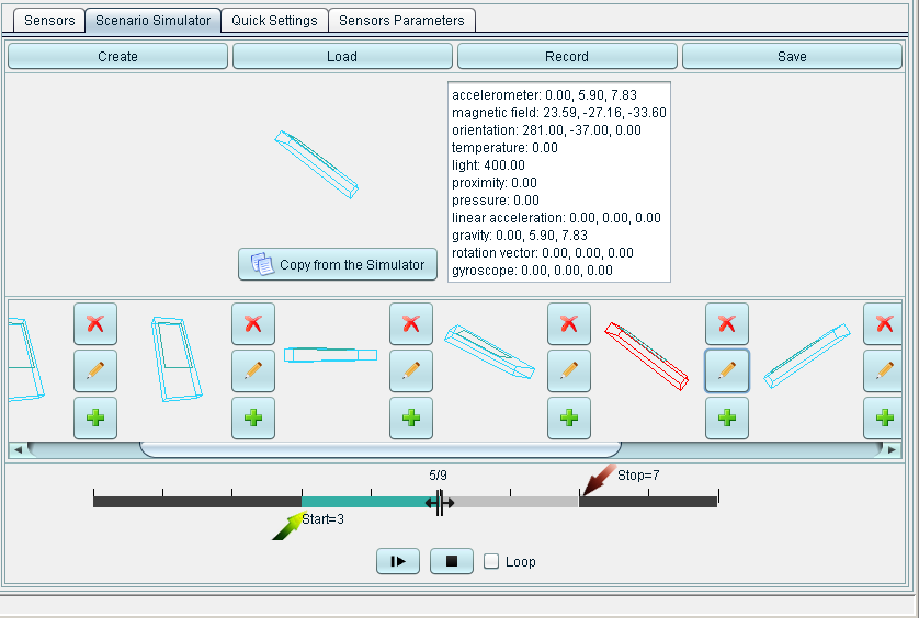
Elena Burceanu’s project aimed to enhance the Sensor Simulator. During the first weeks, the GUI was polished, both in appearance and through clever code restructuring. After enhancing the GUI the number of supported sensors was increased and now includes Android sensors for gyroscope and general rotation vector. Finally, a scenario simulator was added, which creates sensor output from a set of initial states and the ability to change the time intervals between them. The sensor’s values are smoothly interpolated between the key frames. The final product was released as version 2.0. The source code and documentation for Elena’s project are now available to view.

Andras Berke’s project consists of a new application called Historify which displays the user’s activities with others over a variety of communication methods (Voice, SMS, Facebook, etc.), and provides a method for third party applications to supply other activity events showing the interoperability of Android applications. During the summer Andras went through the whole application design process from the UI wireframes to a first beta release including documentation along the way. In addition, he provided demo applications to show how third party developers can interact with Historify. You can now view the source code and documentation from Andras’ summer project.

Sea Turtle Nesting Map


SWOT: Worldwide Green Turtle Nesting Sites 2011 (thumbnail)

Earlier this month, GIS and Science reported that a map of green turtle nesting sites by Andrew DiMatteo, cartographer for the State of the World’s Sea Turtles (SWOT) Project, won this year’s International Conservation Mapping Competition. The map was published in Volume VI of the SWOT Report and is available separately here (PDF). The SWOT project has published a number of maps showing sea turtle nesting sites and biogeography; there’s also an interactive map. If you know me at all, you know how big a fan I am of reptiles in general, so I’m happy to see so much mapping activity dedicated to their conservation.

Bing Maps with a new user interface


Over the past few months, we’ve been testing some enhancements to the Bing Maps interface that we’re excited to now make available for everyone. The most apparent changes are to our task and navigation controls, where—based on your feedback—we’ve made it easier to find the most common actions to complete your task at hand.

For reference, here’s the previous design (pay particular attention to the top and bottom of the page):


Here’s the refreshed version:


We’ve consolidated actions that were previously scattered throughout the page, and concentrated them along the top, where you expect to find them. We’ve included text labels for most of the buttons. And, most importantly, we’ve focused on making the controls accessible while still allowing the map to be the focus of the page.

These improvements are being rolled out to all of our international sites with appropriate market-specific functionality. For example, Bing Maps users in the UK will still have access to the London Street Map and Ordnance Survey styles, along with our standard Road map, via the vector style drop-down. The public transport overlay, showing tube, DLR, and tram networks, is also readily available from the navigation bar when the map is centered over the greater London area.]


You’ve told us you love our unique Bird’s eye 45-degree perspective, viewable from all four compass directions, as well as our high resolution Aerial imagery (see the recent blog post on the Global Ortho Project for more details). As a result, we’ve improved access to these imagery types by making them directly accessible from the top of the navigation bar. At the same time, you can now more easily switch between various road and imagery styles with a single click. You also have the option to view either of the imagery styles with or without labels, depending on your preference.


TIP: Automatically center the map on your current location

If you’re visiting Bing Maps with a browser that supports the W3C Geolocation API, you’ll find a new button (calledlocate me) available to the left of the breadcrumb that, when clicked, will center the map on your current location as reported by your browser.


You’ll receive the highest accuracy results—including a pin and approximate radius—when using a computer with WiFi enabled. You can turn off the pin by clicking the button again. (Note: all browsers will prompt you to share your location after you click the locate me button; if you choose not to allow access, Bing Maps will be unable to center the map on your location.)


We hope you find these changes make Bing Maps simpler and more efficient to use as you focus on completing your map-focused tasks!