The Google AJAX APIs Mark Lucovsky The Google AJAX APIs let you implement rich, dynamic features on your existing web sites entirely in JavaScript and HTML. Using this family of APIs you can add a map to your site, include dynamic search controls, or download and mashup feeds with just a few lines of JavaScript
Deep sea exploration with the joint Indonesia-USA Ocean Expedition
Come on a tour to never-before explored Indonesian waters. The INDEX-SATAL 2010 Expedition is the first-ever joint ocean research voyage by the Republic of Indonesian and the United States. To experience it yourself, watch a Google Earth YouTube video tour here or explore the area more interactively with the Google Earth plug-in on our Ocean Showcase.
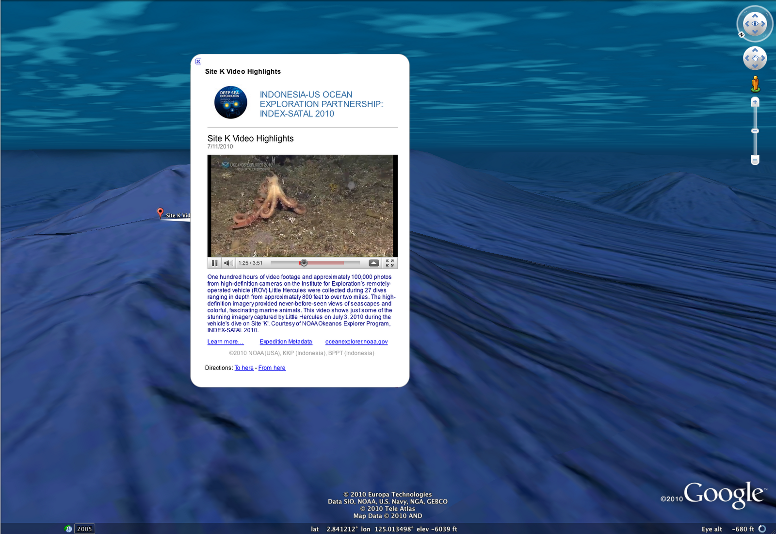
The colored surface areas seen in the video represent underwater terrain data collected during the expedition. The data, highlight photos and videos have been incorporated into Google Earth so you can now explore them on your own by diving under the surface.
Much of the Coral Triangle remains unexplored, and this partnership aims to help reverse the decline of coral reefs in the area and to protect natural resources. The expedition began in the SATAL region around two island chains stretching north of Sulawesi. It was undertaken by scientists from the USA National Oceanic and Atmospheric Administration, Indonesia’s Ministry of Marine Affairs and Fisheries, and the Indonesian Agency for the Assessment and Application of Technology.
“Telepresence” was used to send data in real time to scientists who stood watch at Exploration Command Centers in Jakarta and Seattle. This same technology brought the excitement of the expedition to visitors at the Exploratorium in San Francisco as well.
Little Hercules, a remotely operated exploration vehicle, descended 6000 feet under the sea to capture images and videos of exciting sights like hydrothermal vents and creatures like the deep sea octopus seen below:
Mapping and discovery data from expeditions like this will help all organizations involved better understand ocean resources and how to protect them. More information about the still mysterious ocean will ultimately further economic and environmental initiatives such as the management of sustainable fisheries, the conservation of the marine environment and the preservation of fragile corals.
Dive deeper at Oceanexplorer.noaa.gov.
By Jenifer Austin Foulkes, Product Manager, Ocean in Google Earth and Maps
Geodatabase API
File Geodatabase API BETA – January 2011
Image source: ESRI – File Geodatabase API announced.

The File Geodatabase API provides a non-ArcObjects based means by which advanced developers can work with File Geodatabases. The File Geodatabase API will be C++ based and will provide the ability to perform the following tasks:
- Create, Open and Delete file geodatabases
- Read the schema of the geodatabase
All content within a geodatabase can be opened for read access
- Create schema for objects within the simple feature model
- Tables
- Point, Line, and Polygon feature classes
- Feature datasets
- Domains
- Subtypes
- Read the contents of datasets in a geodatabase
- All dataset content within a geodatabase can be read
- Insert, Delete and Edit the contents of simple datasets:
Tables
- Point, Line, Polygon, Multipoint, and Multipatch feature classes
- Perform attribute and (limited) spatial queries on datasets
- Spatial queries will be limited to the envelope-intersects operator
- Navigate relationships and work with Attachments
This API is targeted for advanced developers who require access to the File Geodatabase without an ArcObjects license for purposes of interoperability. A commonly requested user scenario is to open File Geodatabase tables outside of an ArcObjects based application to view or modify data. This API does not replace ArcObjects as the recommended approach to interacting with the geodatabase.
The File Geodatabase API leverages the work done in ArcGIS 10 to simplify the Geodatabase system tables. Therefore, the File Geodatabase API only supports file geodatabases from release 10 or later. We are planning to deliver the API as a single downloadable ZIP containing:
C++ library (single dll, lib, .h)
API documentation in html format
(Supported on Windows only for the initial release)
Limitations of the File Geodatabase API
While the File Geodatabase API will support reading the schema and data of complex geodatabase types, the API will not honor geodatabase behavior on inserts, deletes or updates to the following dataset types:
- Annotation and Dimension feature classes
- Relationship Classes
- Networks (GN and ND)
- Topologies
- Terrains
- Representations
- Parcel Fabrics
The API will not prevent users from attempting to edit objects with complex behavior, the onus will be on the developer to understand what they should and should not edit through the API and avoid editing datasets that have geodatabase behavior. There will be a method called Table::IsEditable which will provide developers with the ability to determine whether a dataset can be safely edited.
Other limitations of the File Geodatabase API at its initial release:
- Rasters (Raster Dataset, Raster Catalog, Mosaic Datasets and Raster Attributes) are not supported with the initial release of the File Geodatabase API.
- Spatial queries with the File Geodatabase API will be limited to the envelope-intersects operator.
http://blogs.esri.com/Dev/blogs/geodatabase/archive/2010/12/13/File-Geodatabase-API-details.aspx