If you manage data sources in Bing Maps then you know we’ve made several updates to the Bing Maps Account Center and the REST Web Services in the last few weeks. We released more changes to the Bing Maps Account Center including bug-fixes, improved usability and some new features for the management of your own points of interest (POI) in the cloud. The top 3 improvements are:
1. Direct Publishing of Data Sources
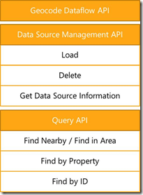
Management of your own data sources in the cloud is generally possible through the Bing Spatial Data Service API as well as through the Bing Maps Account Center. The Bing Spatial Data Service provides a comprehensive set of REST APIs for batch geocoding and reverse geocoding your own POI data sets, uploading them into the Bing Maps data centers, and querying them.
In the past one of the major advantages of the Bing Spatial Data Service over the user interface in the Bing Maps Account Center has been that you were in full control of the data flow. You could decide if you wanted to geocode a data set first or if you just wanted to upload an already geocoded data set. The user interface in the Bing Maps Account Center did not give you that flexibility and would have always geocoded or reverse geocoded your data sets. This could have been particularly unpleasant if you moved your already geocoded data set, for example, from the MapPoint Web Service Customer Data Store or the Multimap Client Zone to Bing Maps. In that case the process behind the user interface would have taken the latitudes and longitudes in your data set, reverse geocoded them, and then would overwrite the address information. With the latest update to the Bing Maps Account Center this limitation has been removed and you are now in full control whether you use the API or the user interface.
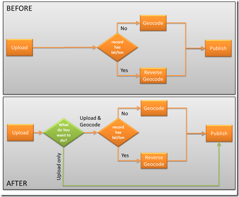
To just upload a data set, check the box Publish without geocoding.

2. Map Navigation for Data Editing
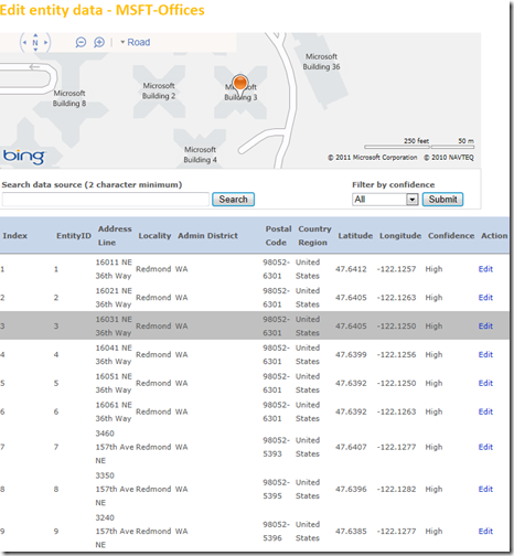
Editing records in a data set has been possible before. However, in order to view the location of a record in the map you always had to click the Edit link. With the latest release you can just mouse over a record and it will show on the map, thus allowing you to have a quick look to decide if editing is necessary at all.
3. Enhanced POI Data Search
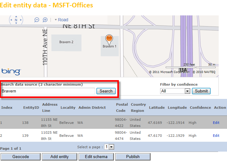
You can now search for any field in the data set even if it is part of the address or a custom field. This feature has been available in the API before, but is now also available in the user interface.
We hope these updates improve your experience with Bing Maps and spatial data services. We are continuing to enhance these services and expand all they can do. Stay tuned for more information coming soon.

![]() and see all of his great works of art. One great feature of the tour is that it is designed to automatically switch to historical imagery when it provides a better view of the art work, showing each piece off in the best possible imagery.
and see all of his great works of art. One great feature of the tour is that it is designed to automatically switch to historical imagery when it provides a better view of the art work, showing each piece off in the best possible imagery.


