Google Earth: 3D trees added to Boulder, Denver and Los Angeles

The addition of trees to Google Earth 6 was an awesome enhancement that made some big cities in Google Earth look remarkably more realistic. While they’re rolling out at a fairly slow pace, it’s nice to see Google continue to push it out to a few more cities.

The newest cities to get the trees are Boulder and Denver, Colorado and Los Angeles, California.

The new trees in Denver are of particular interest to me. I wrote a post on Digital Earth Blog more than three years ago comparing Denver in Google Earth and Microsoft’s (then-titled) Virtual Earth. At the time, Virtual Earth looked far better than Google Earth thanks to the trees. However, Google Earth has blown way past the look of Virtual Earth thanks to the improvements in satellite imagery and 3D buildings in the past few years.

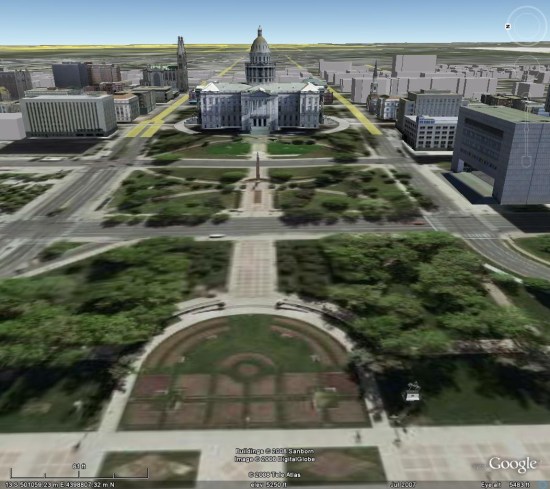
First, here’s a look at the Colorado State Captiol building in Google Earth circa 2007. There are a few modeled buildings, a handful of gray buildings, and certainly no 3D trees:
ge-denver-2007.jpg

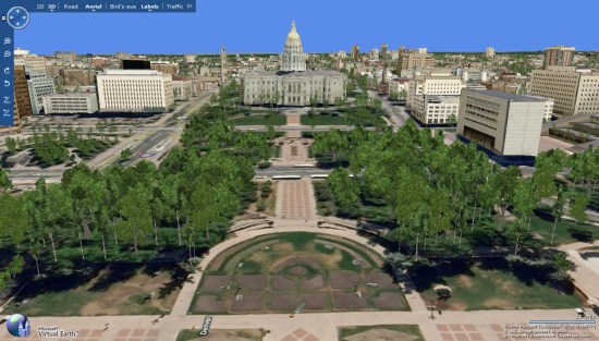
Next, here’s a shot from Virtual Earth, also in 2007. There are quite a few more 3D rendered buildings, but the textures on them aren’t very sharp. The trees are a nice touch, though:
ve-denver-2007.jpg

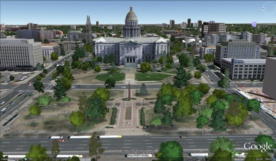
Finally, here’s a look at the same view in Google Earth, as seen today. The buildings are amazingly sharp, and the trees look far more realistic than what we saw in Virtual Earth in the past:
ge-denver-2011.jpg

This comparison helps to show why Google is taking so long between cities with the addition of 3D trees — they’re doing it right. Rather than clumps of virtually identical trees like you saw in Virtual Earth, they’re taking the time to get the right species and height of each tree. The results speak for themselves.

To see these new trees, simply search for Boulder, Denver or Los Angeles in your Google Earth search window and make sure you have [Trees] enabled in the [3D Buildings] layer.

Google Lat Long Blog

Bing Maps: Module for v7 Adds Support for Long Routes

In the Bing Maps v7 control there is the Directions module which allows you to calculate a route with up to 15 waypoints and also generate a nice UI of the resulting directions. Before this module we would have to access the Bing Maps Routing REST service directly to calculate routes. For some this may be still may be the preferred method of requesting routes. The REST services allow you to calculate routes with up to 25 waypoints. In some situations support for routing between a larger number of waypoints may be required. This is where this module comes in. It wraps the Bing Maps Routing REST service and allows you to calculate a route with an unlimited number of waypoints. It accomplishes this by breaking the waypoints into batches and matching multiple routing requests. The results are then merged together into one route response.

This module is easy to use and has two public methods; GetRoute and IsProcessing. The GetRoute method takes in an array of waypoints, a Bing Maps key, a set of route options and a callback method. The IsProcessing method simply checks to see if the RouteServiceHelper class is processing a calculating a route.

This module, along with complete source code and an example implementation can be downloaded here. This module is part of the Bing Maps v7 Module community project on CodePlex, check this project out for other cool and useful Bing Maps v7 modules..

Below is an example of a route with 32 waypoints that was generated using this module.

Currently this module is limited to driving and walking directions, transit directions are not supported. User context information and route tolerances are also not supported. If this functionality is required outside of the Bing Maps V7 control the code in this module can easily be adopted to work on its own in other programming languages. This may be useful in cases where this functionality is needed in backend systems.

rbrundritt.wordpress.com