Google Earth Imagery – September


A Google Earth imagery update is underway! Thanks to sharp-eyed GEB reader ‘Falko P.’ for letting us know about it.


thuringia.jpg 

As is usually the case, you can use Google Maps to determine for sure whether or not a specific area is fresh. This new imagery isn’t in Google Maps yet, so you can compare Earth vs. Maps to see what’s new; the fresh imagery is already in Google Earth, but the old imagery is still in Google Maps. If you compare the two side-by-side and they’re not identical, that means that you’ve found a freshly updated area in Google Earth!

[UPDATED – 7-September, 2:50pm EST]

  • Germany: Ehningen, Flensburg, Hattingen and Thuringia — thanks ‘Armin’, ‘Falko’, ‘marek’ and ‘Michael’
  • Serbia: Lebane — thanks ‘Edi’
  • United States: Iowa (Cedar Falls, Waterloo), Minnesota (Rochester), Wisconsin (La Crosse) — thanks ‘Munden’, 2011 EAA Airventure at Oshkosh

Garmin Chicago gives away a Nüvi

It seems like each day more and more of our social lives become location-based. You  can check in here, tag your friends there, or even sign-up for location-based deals. As a company whose products are location-centric, we totally get where you’re coming from (and we like helping you get where you’re going to). So when we heard about theReady to Move You nüvi 2012 line-up, we thought, let’s reward ourFacebook and Twitter friends who love Garmin just as much as they love checking in.

We’re giving away a nüvi in our 2012 advanced series to whichever of you is the foursquare mayor of the Garmin Chicago Store the moment those models hit our shelves! All you have to do is stop by the store on Michigan Avenue, check in – often – and follow @Garmin_Chicago on Twitter for updates.

We can’t say exactly when we’ll get these new models – which feature Guidance 2.0 with 3D Traffic and photoReal Junction View – but we’re pretty sure it’ll be mid-September. So you’ll want to be sure you’re checking in as often as possible. Remember, only one person can be mayor at the time, and whoever that is when the official “in-stock” update goes out over Twitter will win!

Google Earth: Remember 9/11

With the 10 year anniversary of the World Trade Center attacks coming up in a few days, we thought we’d look at some ways to use Google Earth to remember those lost in the attacks along with ways to look toward the future.

While Google Earth wasn’t released until nearly four years after the towers fell, a handful of models were built to show the towers as they stood prior to 9/11/01. By loading this KML file 
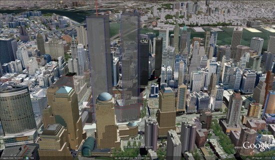
, you can see all of the towers that made up the original set of buildings, including the famous WTC 1 and WTC 2 buildings.
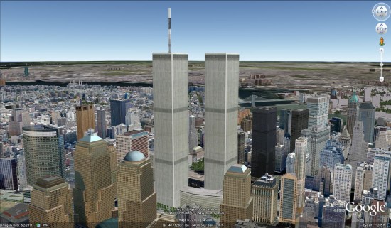
wtc.jpg

You’ll notice that some of the new WTC buildings, still under construction, are already visible in Google Earth. For the purposes of showing the area in a pre-9/11 state, you can right-click those buildings and Hide them. They’ll automatically re-appear next time you start Google Earth.

A more realistic-looking model was created by Patrick Griffin and can be found in the Google 3D Warehouse. His model, seen below, can be viewed by downloading this KML file.

wtc2.jpg

You can also use Google Earth’s Historical Imagery to view images of the twin towers by going back to 1997. The imagery isn’t in color and isn’t very sharp, but clearly shows the towers. You can also view imagery from 9/11/01, and see the smoke and dust as it floats out across the water.

smoke.jpg

There are also a variety of models that somewhat show how the attack unfolded, but none were particularly compelling. If you search the 3D Warehouse for something like “world trade center attack” you can find a few.