The Bing Maps Webcasts Now Open for Registration

The Bing Maps Platform from Microsoft enables organizations to easily and cost-effectively deliver geospatial content to the customers and businesses they serve. Not only does this optimize existing investments in GIS and imagery services, it allows organizations to save money using Bing Maps by making strong connections with customers and exposing relevant content easily on a map from Bing.

Register today to attend a webcast and learn more. Topics include:


What’s New in the Bing Maps Platform?  | February 16, 2012, 2pm Eastern time, 60-minutes

Attend this session for an overview of the latest capabilities in the Bing Maps Platform. You’ll learn the latest on the Bing Maps Imagery program, how to view the meta data and other features in the platform including the best portal to see the latest new imagery sets.


Using the BingMapsPortal.com and keys with Bing Maps Platform | March 15, 2012, 2pm Eastern time, 60-minutes

Attend this session and learn how to use the bingmapsportal.com, tips for using/hiding your Bing Maps key and other helpful development hints.


Bing Maps Spatial Data Services | April 19, 2012, 2pm Eastern time, 60-minutes

Attend this session and learn how to take advantage of the Bing Maps Spatial Data Services included with the Bing Maps Platform for data hosting and findnearby/bound box queries.


Captain James Cook’s circumnavigation of New Zealand

Back in the mid-1700’s, Captain James Cook made a variety of discoveries around the world including the first European contact with the eastern coastline of Australia and the Hawaiian Islands. In addition, he recorded the first circumnavigation of New Zealand.

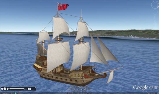
Colin Hazlehurst has put together an amazing tour of Cook’s circumnavigation, featuring an excellent 3D model of his ship, constructed by Phillip Müller.
ship.jpg

To see it for yourself, you can download this KML file.

Here’s a brief overview of Cook’s journey, taken from the KML file:

His Majesty’s Bark Endeavour sailed from Plymouth on Friday, 26Aug1768 with Lieutenant James Cook as Commander. The mission of the Endeavour was to boldly go…oh no that’s Kirk not Cook.

The first objective of Cook’s voyage was to observe the transit of Venus from the island of Tahiti in June, 1769, and after that to explore the Pacific with a view to determining whether or not there was a large southern continent.

At 2 p.m. on Saturday, 7th October, 1769, land was seen from the masthead of Endeavour bearing west by north; this was the North Island of New Zealand and James Cook gave the order to stand in for it.

The ship anchored in Poverty Bay in the afternoon of 8th October, yet it took another four months to complete the circumnavigation of the island.

From Poverty Bay, Cook first took the Endeavour southwards along the coast as far as Cape Turnagain, where he decided it would be more fruitful to explore to the northwards. By meticulous observation of the sun, moon, and stars, Cook charted the coastline, noting the hazards to shipping and the places where there was safe anchorage and plentiful wood and water.

Always along the way, he tried to befriend and trade with the people he met, though not every encounter was successful. There were well-armed, warlike people who lived in strategically placed strongholds, but also friendly and curious people who were happy to trade fish and other seafoods for cloth and nails. Cook always regretted the taking of life, but sometimes it was necessary in self-defence.

He rounded East Cape on 31Oct1769 and made his way along the coast in a broadly north-westerly direction. He made extended visits to the Bay of Islands and Mercury Bay, this last so named because they observed the transit of Mercury, and so were able to fix the latitude and longitude of the bay to a high degree of accuracy.

It took more than 3 weeks to round North Cape, in the face of westerly gales, strong currents, and a broad swell. Cook found it impossible to land on the ‘dangerous’ west coast of North Island, finding no safe harbour or anchorage. He rounded Cape Egmont and made his way to Queen Charlotte Sound where the ship was careened and scrubbed.

After narrowly avoiding the small islands called The Brothers, Cook took Endeavour through Cook Strait and started to explore the east coast of South Island. However, to prove to his officers that North Island was indeed an island and not part of a larger continent, he took advantage of a favourable wind to complete the circumnavigation of North Island on 09Feb1770.
ship2.jpg

In Colin’s words, here’s how the file itself works:

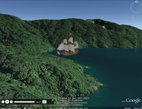
This Google Earth presentation animates the 3D model of a ship as it follows the track of the Endeavour, and is accompanied by a reading of Cook’s journal. The circumnavigation of North Island is divided into sections which have significant start and end points. In Google Earth terminology, each section is known as a ‘tour’.

To play a given tour, first find it in the Table of Contents folder. You will see the name of each tour displayed as a hyperlink against a Folder icon, e.g. Poverty Bay to Cape Kidnapper. A single click on the hyperlink will display an information balloon which shows, for that tour:

• The start and end dates of the journey.
• The duration of the tour in minutes and seconds, being the length of time it will take to play the tour in Google Earth.
• Start a tour by expanding the Folder to show the Tour icon and the title ‘Play’ and double-clicking the icon.

via: Google Earth Blog

The Place Based Bubble Ads

Should every place & business that exists in our everyday life be used to sell against? Should that specific, very real entity with its history of sentiment and purpose be leveraged to shill for something without their knowledge? And if so what is appropriate to sell against that place? I asked myself those questions as I explored some of the “bubble ads” that Google was showing in the info bubble for these Places.

When Google Adwords are shown against a full page of search results based on relevancy and various matching type, some of the quirks of the system are not obvious. However when an algo tries to position one ad against a single Place that exists in reality the limits of an algo based placement become more obvious. The lack of upfront human curation creates unpredictiable and oftimes odd outcomes. The results can easily pass from the mundane into tasteless very quickly.

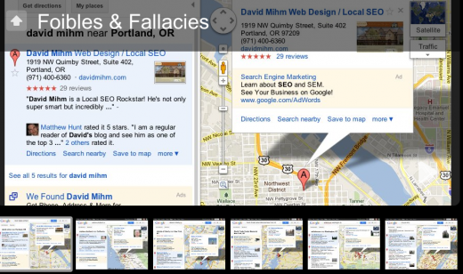
The issue certainly affects small business as they find their competitors  both local and national advertising against their good name. In this slide show you will see Google leveraging David Mihm and Andrew Shotland‘s reputation to highlight their own Adwords product as an alternative to either’s service (yea right).

But that annoyance felt by an SMB at Google’s ham handed selling pales when you see Google let someone selling against icons of American culture. A private, for profit tour positioned against the Statue of Liberty seems odd but one positioned against the 9/11 memorial seems downright macabre.

There is humor as well as you see the Obama campaign selling against the Whitehouse with a desire to live there another 4 years. The Yellowpages selling against a church certainly strikes an odd note. But that same humor turns black when you see abortion ads positioned against a Women’s Homeless Shelter or Health Clinic.

Obviously when the level of granularity gets down to the local business or place the foibles of this sort of advertising becomes painfully obvious. It reminds us all that we now live in a culture where every thing is for sale and every white space is ripe for an ad placement. Google’s info bubble ads that are now cluttering Google Maps give Maps the feel of those “park benches” that sit at smogged covered street corners with ads on their backs and facing into traffic. These effectively become the grafiti of our virtual world only they  are not painted by rebel outsiders and they are paid for with real dollars. The ads manage to remind us that all too often that the value of humanity has been reduced to the value of the individuals’ “eyeballs” and their willingness to read the message.

Google has taken a technology that not that long ago reminded us of the wonder of online possibilities and defaced it in a way that has smacks of the billboards and signs that all too often covers the walls of public spaces and bombard our senses with commercial messaging at every turn. The only thing missing from Maps to complete its drive to mirror reality are the whiffs of the urine that all too often cover these same walls. Although I don’t doubt that Google would ad scents if there was a way to monetize them.

Obviously not all of you agree with my disdain for Google’s new efforts. But all of you can find the humor and spot the tasteless gaffs of this advertising method. If you find a particularly ironic, distasteful or inappropriate “Bubble Ad” kindly send along a screenshot for my “Rogues Gallery of Bad Bubble Ads”.

Click to view the slide show: