Google Maps: Feel the Heat

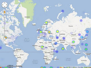
We’ve been talking a lot recently around the Maps Developer Relations Team about heat maps. Heat maps use colors to represent the intensity of occurrence or certain values. Heat maps are a popular way to represent data. People often ask me how to create them themselves. So the other day when I ran across heatmap.js, with it’s nifty Google Maps API Heatmap Overlay, I thought it would be perfect to share with you. Heatmap.js uses HTML5 Canvas to render the heatmap on top of the map. Apparently, it’s in early release, so feel free to help the developer, Patrick Wied out with some patches. Here’s what it looks like:

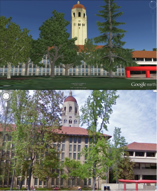
On another note, we recently announced that several college campuses are now available in Google Street View, in areas outside roads. That data is now available to you in the Google Maps API. Here’s the Quad at Stanford:

Finally, if any of you are going to be at Strata, Chris Broadfoot and I will be presenting a workshop there March 1st called Beautiful Vectors. Check it out or just find us and say hi.

via: GoogleGeoDevelopers

The New War Horse Interactive Map on MSN

Many of you have heard of Steven Spielberg’s latest hit movie War Horse, which came out in USA theatres on December 25 and is launching in Europe in January. What you may not have heard of is the War Horse Journeyon MSN. It’s a tool that allows you to explore the journey of Joey (the war horse). For more on the Journey tool, check out this MSN Blog Post. We at Bing Maps just wanted to call out our partner in the UK, Shoothill, who worked with the movie to create a true one-of-a-kind mapping experience!
Here’s a quick overview of the Timemap in the War Horse Journey, but nothing can compare with just spending time in the map itself. The Timemap combines present day maps with WWI era imagery all in one place! It has 3 components: video/photos, aerial photos and historic maps. The fade slider functionality lets you compare maps from WWI with today. Take a look…
Villers Bretonneux, France
December, 1917
Villers Bretonneux, France
Present Day
Historic trench map of Kemmel, Belgium
April, 1917
Belgium landscape today
Go spend some time playing around with the Timemap and the War Horse Journey. The Timemap is an incredible way to explore history and shows the lasting mark WWI has made on our world.
Note that the War Horse Journey is available for a limited time only, so get out there and experience history today!

Explore university campuses in 3D and StreetView


As part of the continual additions to Street View, Google has just added more university campuses around the world to the product, bringing the total number of Street View-able campuses to nearly 100.

Combine that with the fact that thousands of new 3D buildings are added to Google Earth each week, along with 3D trees in a growing number of cities, and you have some excellent tools at your disposal to help browse around your favorite college.

For example, below is Stanford University shown in Google Earth and Street View so you can compare the views:


stanford-comp.jpg 

Google has spotlighted a few other universities in a recent blog post and you can view the full list of Street View-enabled campuses on their site.

You can also view some extra goodies at a few schools (like the virtual campus at Northeastern University) and utilities such as Campus Bird help provide more geo context for hundreds of schools.

As good continues to add Street View at more schools, and schools continue to work on their 3D buildings, this kind of exploration will only get better!