It’s Tax Time but Don’t Search for the IRS in Sturgis MI

It’s tax time so folks all across the US are calling the IRS with questions. Where are many of them getting the number? Well Google of course.

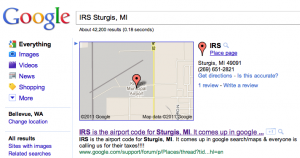
If you live in Sturgis, MI (population 10,696) though you need to be careful. If you search for the IRS in Sturgis, you will be given the local airport instead whose 3 letter airport code is… IRS. If you call the number you might just can earful rather than helpful tax advise. Ah the power (and the pain) of Local Search.

From the forum (bold is mine):

IRS is the airport code for Sturgis, MI. It comes up in google search/maps & everyone is calling us for their taxes!!!!

About 2 months ago we started receiving phone calls from individuals wanting to contact the Internal Revenue Service. We are the Kirsch Municipal Airport located in Sturgis, MI and our FAA Airport code is IRS. Somehow, when people google search/map IRS – our information comes up – not the Internal Revenue Service. We get 20-50 calls a day for the Internal Revenue Service – even after hours and on weekends.

2 weeks ago, I sent several report a problem issues to google maps – with no response from them. I have sent them several every day since – with no response from them. I rated it a bad rating with information why also.

Last week I figured out how to request a change to the information on google maps. I submitted the change and received a response that said they’d look at it an let me know. Still – no answer.

I am sooo fed up with this issue and please help me fix it asap! Thanks!

The problem points out not just the power of having a popular search term ranked highly in local but the frustration felt by those on the wrong end of the accuracy issue and the struggle that novice users find with Google’s interface. The user discovered the report a problem link, then went on to the community edit. She has yet to find the claim link but hopefully that will occur shortly.
Rediscover Historical Imagery in Google Earth 6

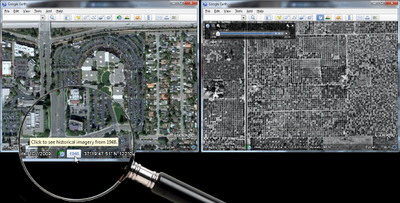
Historical imagery is one of the most powerful features of Google Earth, enabling you to go back in time and browse the visual historical record of our planet – from the evolution and rise of developing communities to the destruction caused by hurricanes, earthquakes and fires. With Google Earth 6, we’ve made it easier than ever to discover historical imagery. In addition to streamlining the timeline interface, we’ve added a date button to the status bar to notify you of past imagery that you might be interested in exploring. So now, when you zoom in on a location in our latest version of Google Earth, the button will appear highlighting specific years. Clicking it enables historical imagery and takes you back to the year you selected. For instance, when I zoom in on the headquarters of a certain company with a fruit namesake nestled in the heart of Silicon Valley, Google Earth suggests imagery from 1948. Clicking the date button reveals the fruit tree orchards that used to inhabit that very location. I wonder if they were apple trees.
Google Earth 6 suggests historical imagery to explore, e.g. of Silicon Valley in 1948
In the almost two years that historical imagery has been available, we have captured several moments of cultural significance, such as the inauguration of the first African American President of the United States, the devastation of Hurricane Katrina, and the transformation of South Africa in preparation for the 2010 FIFA World Cup.
Washington D.C., January 20, 2009. Can you spot where the jumbotrons were installed?
But the feature is more than just what historians deem significant. We built the historical imagery database to enable anyone to see and tell their own personal history. A great example comes from fellow historical imagery engineer Reuel Nash:

The construction of Terminal D at Dallas/Fort Worth International Airport
We have a vast amount of data in our historical imagery archive, so you’ll be able to tell your own personal stories by browsing those places that are special to you. In fact, we have more square miles of high resolution imagery in our historical imagery archive than in our default view. In the coming years, we look forward to expanding this imagery collection even further. Visit the Historical Imagery Showcase to watch video tours of cities with imagery dating as far back as 1940.
Posted by Chris Co, Google Earth Software Engineer

In 1979, my wife and I spent the first night of our marriage in a hotel at Dallas/Fort Worth International Airport. It was still there in 1995, which you can see in Google Earth. The hotel and the surrounding area has since been replaced by Terminal D. You can see the terminal construction (and destruction of the hotel) literally from the ground up using historical imagery.

Getting from A to B just got a little easier

Over the past year, the Google Maps Directions team has been hard at work developing a variety of design improvements to make getting and following directions much easier.

It’s now simpler than ever to switch transport modes, change the time/date of your trip, get a high-level overview comparing different routes, and view details of a single trip at-a-glance.


To explore these improvements in more depth, let’s imagine that you’re planning a trip to visit the beautiful city of Zürich, and would like to take public transportation from the airport to your destination in town.

We’ve made it super quick and easy for you to see all the available modes of transportation when you’re planning a route – you can see that driving, public transit, and walking are all available in this area. The options for setting a time and date for your trip are also now open by default for public transit
Having selected your start location and end destination, you are presented with a series of suggested routes to take you from A to B. Each description is now much richer, making it easier to differentiate between similar routes:


Once you select a route, the individual steps for the trip are dramatically simplified and cleaner in the new design. The stations at which you’ll need to transfer, and the number of stops in between are now much more apparent. The sections of the route that involve walking are also much easier to spot since they’re indicated by a dotted line on the left:


Clicking on any step will also display more information. For example, we now show the stop preceding the one where you’ll need to get off, so that you can get your bags ready and prepare to disembark. And we’ve introduced turn-by-turn direction indicators for walking, driving and cycling:


Stay tuned for further changes as we continue to refine and improve your experience using directions from Google Maps. Enjoy your travels!