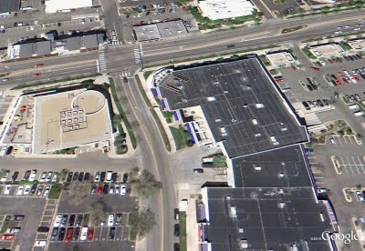
Google Earth: Imagery Update Week of July 18th

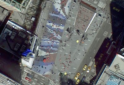
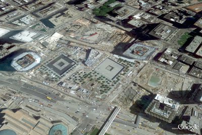
The Commissioners’ Plan of 1811 proposed a highly regular grid pattern as the layout for an island that was mostly farmland and wilderness in a still-young country. Two hundred years after the streets and avenues were dreamed up, the landscape of New York City has changed dramatically as skyscrapers have been built, parks have been planted and the population has increased by millions. Today’s latest batch of updated imagery reveals new, high resolution imagery of Manhattan. It’s now live in Google Earth and will appear in Google Maps soon.

Times Square has become much more pedestrian-friendly.

Construction at the World Trade Center site is making clear progress.
Google NYC is located in the Chelsea neighborhood of Manhattan. I’m one of more than 2,000 Googlers here (split between Sales, Engineering, and other functions), making us the second-largest Google location. (Care to join us?) The sales team sits in Chelsea Market, a former Nabisco factory where Oreos were invented and which envelops the elevated High Line, which was recently converted into a park.

This new batch of imagery also covers another Google hometown: Boulder, Colorado, home to the 3D team that brings you Google SketchUp and the Google 3D Warehouse. That team expanded two months ago across the street. 

Want to check out how these places used to look? Use the Historical Imagery feature of Google Earth to slide back the clock around the world. And as always, we encourage you to check out more of the areas that can be seen in our latest imagery update. Enjoy!

High resolution aerial updates:

Boise, ID; Denver, CO; Topeka, KS; St Cloud, MN; Ashland, WI; Ironwood, MI; Flint, MI; Ft Wayne, IN; Cape Girardeau, MO; Bowling Green, KY; Glasgow, KY; Greenville, NC; Atlantic City, NJ; Syracuse, NY; Manhattan, NY

Countries/regions receiving high resolution satellite updates:

Canada, United States, Mexico, Cuba, The Bahamas, The Dominican Republic, Belize, Guatemala, El Salvador, Honduras, Nicaragua, Costa Rica, Panama, Colombia, Venezuela, Ecuador, Brazil, Peru, Paraguay, Bolivia, Argentina, Chile, Madagascar, South Africa, Lesotho, Swaziland, Namibia, Botswana, Mozambique, Zambia, Angola, Tanzania, Democratic Republic of the Congo, Uganda, Kenya, Somalia, Ethiopia, Sudan, Eritrea, Egypt, Niger, Burkina Faso, Ghana, Sierra Leone, Mali, Senegal, The Gambia, Mauritania, Morocco, Algeria, Yemen, Saudi Arabia, United Arab Emirates, Qatar, Kuwait, Jordan, Israel, Syria, Lebanon, Iran, Turkey, Russia, Finland, Sweden, Norway, Estonia, Latvia, Belarus, Ukraine, Poland, Hungary, Romania, Bulgaria, Greece, Albania, Serbia, Croatia, Austria, Germany, Italy, Switzerland, France, Spain, Portugal, England, Azerbaijan, Kazakhstan, Uzbekistan, Kyrgyzstan, Pakistan, India, Sri Lanka, Bangladesh, Nepal, China, Myanmar, Laos, Thailand, Vietnam, Cambodia, Malaysia, Taiwan, The Philippines, Japan, Korea, Indonesia, Australia, New Zealand

These updates are now available in Google Earth and coming soon to Google Maps. To get a complete picture of where we updated imagery, download this KML for viewing in Google Earth.
Free data a GFC casualty

The US government has been a proponent of free data for quite a while now and over the years it established a number of national programs to allow easy access to wast resources of public information. However, the annual budgets for e-government initiatives were slashed by 75% last month, putting in question the survival of such programs like data.gov (it is the repository for publicly available data that was promised as a platform to power software and analysis created by and for the public). Comments from federal CIO Vivek Kundra indicate that data.gov will not be shut down but “…there will be no enhancements or other development to address needs for improvement”. So, although the policy of free data remains unchanged, significant cost of delivering that policy may be its ultimate “undoing”.

Meantime, in Australia, the progress towards opening up government data vaults has taken another step forward. Earlier this week Australia’s Information Commissioner, John McMillan, unveiled eight new rules for Federal agencies to adhere to when considering the publication of government data. These rules are:

  • Open access to information – a default position,
  • Engaging the community,
  • Effective information governance,
  • Robust information asset management,
  • Discoverable and useable information,
  • Clear reuse rights,
  • Appropriate charging for access, [So, not entirely free access!]
  • Transparent enquiry and complaints processes

The Principles are not binding on agencies, and operate alongside legal requirements about information management that are spelt out in the FOI Act, Privacy Act 1988, Archives Act 1983 and other legislation and the general law.

Despite the launch of data.gov.au portal, there is no federal program in Australia to facilitate access to public data on a large scale (ie. the US style) and the onus so far is on individual agencies to manage the dissemination of public information in their possession. State and Territory governments are pursuing their own initiatives. This “piecemeal approach”, although slower in implementation, may prove to be a more sustainable model for enabling access to public data, considering the vulnerability of large scale initiatives to budgetary pressures of the government of the day in these uncertain times.

Watching the Lunar Eclipse

We’re always fascinated by the unique wonders of space and the world—what can we say, it’s the geek in us! Naturally, when we learned that part of the world will be treated to a rare 100-minute long total lunar eclipse starting at 11:20am PDT today, we were both excited and disappointed that this rare occasion wouldn’t be visible from our Mountain View campus like last year’s eclipse. We suspect we aren’t alone, so you’ll be glad to know that we’ve worked with Slooh Space Camera to let you experience the spectacle wherever you are in the world, in real time.


Slooh will host a live mission interface using Google App Engine that lets anyone not lucky enough to live in certain areas (South America, Europe, Africa, Asia and Australia) take part in this rare astronomical event. It’s equipped with audio narrations from real-life astronomers so you can hear a firsthand, expert account of the event. You can also watch the live stream on the Google YouTube Channel or from the Sky layer in Google Earth (download this kml), while exploring the fascinating world that exists in our galaxy. Finally, those of you on the go can download the Slooh Space Camera Android app to view the images right on your phone.

If you’re fortunate enough to be able to view this event in the sky, we hope you’ll get the chance to step outside and indulge in the spectacle. For everyone else, we hope our moon madness helps brighten your day.