The Bing Maps Windows Presentation Foundation Control v1

Back in August, was announced the Beta for our Bing Maps WPF control. The uptake in the Microsoft Developer Community has been stellar and the feedback – immensely helpful. As a result and as promised to those across the Microsoft Developer Network, we’re officially releasing The Bing Maps Windows Presentation Foundation Control, Version 1.

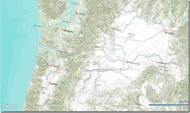
Bing Maps WPF Control with an ESRI Topographic Map Tile Overlay

The control was built atop of the beta, so we still have all of the touch enabled greatness for Surface v 2’s Pixel Sense, inertia and full rotation. We’ve kept most of the classes, methods and properties in place from the beta – requiring little work to install and register v1. And, per community feedback on the Bing Maps MSDN Forums we added the following features (and fixed a few bugs):

  1. Support for tile layers – you can now overlay your own tile layers atop the map control.
  2. Turning off the base tile layer – this is useful for when you don’t need/want to use our base map tiles and instead would prefer to use your own without overlaying them atop of ours. The control won’t request the tiles which reduces downloads and improves rendering performance.
  3. SSL Support – since many of you are using the WPF control in secure applications, you can now make tile and service request over SSL without issue.
  4. Hiding the scale bar – if you don’t want a scale bar (perhaps your map is small and the scale bar clutters the map) you can turn it off. In fact, the only elements you can’t turn off are the Bing logo and the copyrights.
  5. New copyright service – provides accurate copyright for our data vendors.
  6. Additional inertia – inertia is now enabled for the mouse and is on by default for touch.
  7. Miscellaneous bug fixes – thanks for the feedback on the MSDN Forums, the Bing Maps Blog, e-mail and Twitter. Good finds people.

I have to give it up for my (small) crack team of people involved in the making of the WPF Control. This was one of those 10% projects that we all really had a passion to get done because it was the right thing to do for the Microsoft Developer Community. So, we found the time, slipped the release a month (for quality) and, as the guys over in Surface said, “just got it done.” Our internal motto kept stoking the fire to push this bad boy out the door…”WPF, FTW!”

Now, download the Bing Maps WPF Control, build a killer app and make us proud.
NAVIGON 2.0 Navigation App for iPhone

A couple of months ago, Garmin acquired Germany-based navigation provider NAVIGON to extend ther footprint in Europe and in the mobile applications space. Just like Garmin, these guys develop great products and we’re excited to work with their team.
Now, NAVIGON announced a broad overhaul of its popular iPhone navigation app that includes a couple of major improvements, so we wanted to make sure you’ll be able to check out the details.

Like Garmin’s StreetPilot OnBoard app, NAVIGON for iPhone is an onboard navigation app that saves the maps on the device to stay independent of cell phone coverage. This is really helpful when you lose your data connection, since you’ll still be able to navigate and calculate new routes. But it also means that you have to save large amounts of map data on your phone. NAVIGON 2.0 is the first onboard navigation app that solves this issue by allowing users to download maps by state. You can simply pick the maps you need and download additional ones at a later point (WIFI connection required).

Navigation systems have become more complex over the last years, so NAVIGON has also rethought the way the app interface is structured. As a result, the new version is more intuitive and easier to use than ever before. In addition, NAVIGON 2.0 also includes an in-app purchase option for quarterly map updates.

Watch the video below to see the new features in action.

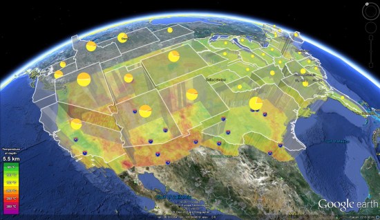
The Geothermal Systems in Google Earth


Google.org was using Google Earth to visualize Geothermal Data in the United States.

Google has continued to increase the amount of data behind the map, making it a more and more powerful tool as times goes on.


geothermal.jpg 

If you’re unclear on what Enhanced Geothermal Systems (EGS) are about, read this snipped from the Google.org EGS page:

Enhanced Geothermal Systems, or EGS, attempts to do just that. EGS produces heat and electricity by harnessing the energy from hot rock deep below the earth’s surface, expanding the potential of traditional geothermal energy by orders of magnitude. EGS is a big challenge, but with the potential to power the world many times over, it demands our immediate attention. At Google we support efforts to advance EGS through R&D, investment, policy and information.

To see this data for yourself in Google Earth, simply load this KMZ file (which was last updated just a few days ago). Also worth your time is this short article in Forbes that talks a bit more about how EGS could benefit all of us.