The Bing Maps Windows Presentation Foundation Control v1

Back in August, was announced the Beta for our Bing Maps WPF control. The uptake in the Microsoft Developer Community has been stellar and the feedback – immensely helpful. As a result and as promised to those across the Microsoft Developer Network, we’re officially releasing The Bing Maps Windows Presentation Foundation Control, Version 1.

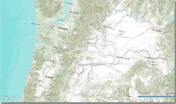
Bing Maps WPF Control with an ESRI Topographic Map Tile Overlay

The control was built atop of the beta, so we still have all of the touch enabled greatness for Surface v 2’s Pixel Sense, inertia and full rotation. We’ve kept most of the classes, methods and properties in place from the beta – requiring little work to install and register v1. And, per community feedback on the Bing Maps MSDN Forums we added the following features (and fixed a few bugs):

  1. Support for tile layers – you can now overlay your own tile layers atop the map control.
  2. Turning off the base tile layer – this is useful for when you don’t need/want to use our base map tiles and instead would prefer to use your own without overlaying them atop of ours. The control won’t request the tiles which reduces downloads and improves rendering performance.
  3. SSL Support – since many of you are using the WPF control in secure applications, you can now make tile and service request over SSL without issue.
  4. Hiding the scale bar – if you don’t want a scale bar (perhaps your map is small and the scale bar clutters the map) you can turn it off. In fact, the only elements you can’t turn off are the Bing logo and the copyrights.
  5. New copyright service – provides accurate copyright for our data vendors.
  6. Additional inertia – inertia is now enabled for the mouse and is on by default for touch.
  7. Miscellaneous bug fixes – thanks for the feedback on the MSDN Forums, the Bing Maps Blog, e-mail and Twitter. Good finds people.

I have to give it up for my (small) crack team of people involved in the making of the WPF Control. This was one of those 10% projects that we all really had a passion to get done because it was the right thing to do for the Microsoft Developer Community. So, we found the time, slipped the release a month (for quality) and, as the guys over in Surface said, “just got it done.” Our internal motto kept stoking the fire to push this bad boy out the door…”WPF, FTW!”

Now, download the Bing Maps WPF Control, build a killer app and make us proud.
Springsteen on Fire and Worry


“You can’t start a fire worrying about your little world falling apart.”

–Bruce Springsteen (1949 – )

American music artist

What you expect to happen – what you believe in your mind – can have a tremendous impact on what actually does happen.

If you’re going to try to accomplish something – if you make the decision to make the attempt – the best thing you can do for yourself (and your colleagues) is to expect a positive outcome. Anything else can only inhibit your efforts.

Worst-case: If you fail, you get an education for your future efforts.


Remember…

We earn more challenges by dealing with and overcoming more challenges.

Embrace your experience. Enjoy the weather.

___________________________

Seattle.gov ‘My Neighborhood’ – Bing Maps

Seattle.gov ‘My Neighborhood’ – Bing Maps

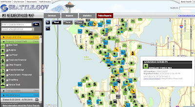
Seattle.gov have launched this ‘My Neighborhood’ include Crime reports Map.
The crime icons are based on initial police reports taken by officers when responding to incidents around the city. The information enters Seattle Police Records Management System and is then transmitted out to the Bing map.

Note: This data and their corresponding map icons will populated on the ‘My Neighborhood’ map within 6 to 12 hours after the report is filed into the system.

Seattle Police 'My Neighborhood' Crime Map
Use the left-hand side bar in choosing date (by calendar), types of crime (Crimes Against Persons, Drugs and Vice, Property Crime/Theft, Transportation & Miscellaneous sub- catergories). Advice is not to switch everything on at once.

About the data:
The mapped icons are based on police reports taken by officers when responding to incidents around the city. The time for an incident to show on the map is 12 hours after the report has been processed. However, the time for a report related to the event to be made available online can take 2-3 business days.

Important Note:
This map provides a good overview of reported activity going on in the Seattle neighborhood. The icons for these incidents are based on initial reports, however, and are subject to change as the investigation proceeds. For this reason, the mapped incidents will not match monthly crime statistics and will not provide a true measure of safety or crime in an area.

View the Seattle Police “My Neighborhood” Bing Map
http://web5.seattle.gov/mnm/policereports.aspx

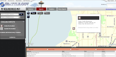
On the same Bing Map it is possible to view live Fire or Medical impacts
Seattle Police 'My Neighborhood' Fire and Medicial Map
Using the ‘Impacts’ tab on the map will change from crime to Fire Incidents (with covers medicial) assistance – this map is updated every 2 minutes.

View the Fire/Medicial Map
http://web5.seattle.gov/mnm/default.aspx?tabId=2